Memorandum
Date: January 23, 2014
To: Boston Region Metropolitan Planning Organization (MPO)
From: Chen-Yuan Wang, MPO Staff
Re: Route 3A Subregional Priority Roadway Study in Cohasset and Scituate
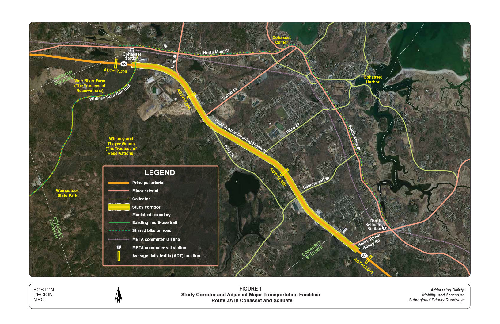
The roadway segment of Route 3A from the driveway of the Massachusetts Bay Transit Authority (MBTA) commuter rail station in Cohasset to Henry Turner Bailey Road in Scituate is one of two corridors selected for analysis as part of a larger study funded by the Boston Region MPO: Addressing Safety, Mobility, and Access on Subregional Priority Roadways.1
This memorandum summarizes the existing conditions and issues, roadway operations and safety analyses, and the proposed short-, medium-, and long-term improvements for the entire corridor and at specific locations. It contains the following sections:
This memorandum also includes technical appendices that contain relevant data and methods applied in the study.
During the MPO’s outreach for the development of the Unified Planning Work Program (UPWP) and the Long-Range Transportation Plan (LRTP), Metropolitan Area Planning Council (MAPC) subregional groups and other entities submit comments and identify transportation problems and issues that concern them. Often these issues are related to bicycle, pedestrian, and freight accommodation, bottlenecks, safety, or lack of safe or convenient access for abutters along roadway corridors. Such issues can affect not only mobility and safety along a roadway and its side streets, but also livability and quality of life, including economic development and air quality.
To address these kinds of concerns, this study was included in the federal fiscal year (FFY) 2013 UPWP.2 The purpose of this study is to identify roadway segments in the MPO region that are of concern to subregional groups but that have not been identified in the LRTP regional needs assessment.
This study focusses on issues identified by relevant subregional groups and the recommendations developed to address these issues. In addition to mobility, safety, and access, the study will consider transit feasibility, truck issues, bicycle and pedestrian transportation, preservation, and other topics.
The study area, Route 3A in Cohasset and Scituate, was selected through a comprehensive process. First, MPO staff identified potential study locations via various sources: soliciting suggestions during the outreach process for the FFY 2014 UPWP; reviewing meeting records from the UPWP outreach process for the past-five years; and appraising potential locations in the MPO’s LRTP Priority Corridors study and monitored roadways in the MPO’s Congestion Management Process (CMP) program.
MPO staff identified 20 roadway sections in the MPO region as potential study locations. Staff assembled detailed data on the identified roadways and evaluated them according to five selection criteria:
Two roadway sections were selected and approved by the Boston Region MPO for study:4
The Route 3A corridor is located in an area currently being developed. It serves residents, commuters, and local businesses, and connects two major MBTA commuter rail stations. The South Shore Coalition and the Towns of Cohasset and Scituate strongly support this corridor for study.
The objectives of this study are to:
This study focuses on a three-mile section of Route 3A from the driveway of the MBTA commuter rail station in Cohasset to Henry Turner Bailey Road in Scituate. The entire section is under the jurisdiction of Massachusetts Department of Transportation (MassDOT), Highway Division District 5.
With the assistance of MassDOT and Cohasset and Scituate, MPO staff collected intensive roadway traffic and speed data; intersection turning movement counts (including pedestrian and bike movements and heavy vehicle percentages); information about current and future adjacent developments; and multiple-year crash reports (from police departments) for the study corridor.
In addition, to support the analyses in this study, staff collected relevant transportation and land use data in the South Shore region adjacent to the study corridor.
During the course of the study, MPO staff conducted two meetings with representatives from the Towns of Cohasset and Scituate, MassDOT, and MAPC. The purpose of the first meeting, held on March 14, 2013, was to introduce and coordinate the study and to discuss the concerns of the two Towns and MassDOT about the study corridor. The second and final meeting, on September 5, 2013, was held to present the analyses and findings and review the proposed improvements with the Towns and MassDOT. Meeting participants included board members, planners, engineers, and police and fire officers from the Towns, and officials from MassDOT District 5. Appendix A contains a list of participants in the two meetings.
This section describes the corridor’s location; adjacent major transportation facilities’ roadway configuration and facilities; and observed operational and safety conditions. It inventories current and future developments, and summarizes issues and concerns raised in the study advisory meetings.
Route 3A is a major state roadway in eastern Massachusetts, which runs north from Plymouth to Tyngsborough, at the northern New Hampshire state line. Its southern portion, mostly parallel to Route 3 and located near the coast, connects Route 3 in Plymouth and Interstate 93 (I-93) in Boston’s Dorchester neighborhood. Route 3A traverses a number of communities including Plymouth, Kingston, Duxbury, Marshfield, Scituate, Cohasset, Hingham, Weymouth, and Quincy. Along with Route 3, Route 3A is regarded as a significant travel corridor on the South Shore.
Figure 1 shows the location of the study corridor and major transportation facilities in the area. Most of the three-mile corridor selected for this study is located in Cohasset, with a short section in Scituate. The entire section is classified as a principal urban arterial. It is mainly a two-lane roadway (one travel lane in each direction), except for a four-lane section (two travel lanes in each direction) about a quarter mile long in a Cohasset business district south of Beechwood Street. The roadway’s travel lanes are about 12 feet wide, with a shoulder of about two feet or less. There are no sidewalks on either side of the roadway and no exclusive bike lanes.
The corridor serves both local and regional traffic from residents and businesses and is located in an area that currently is being developed. It is also a major commuting route for people working in Boston, Quincy, and other South Shore communities. Based on the traffic counts collected for this study (April-May 2013), the corridor carries about 15,500 to nearly 22,000 vehicles per day.
In the study area, Route 3A intersects three minor arterials: King Street (northern segment) and Sohier Street in Cohasset and Henry Turner Bailey Road in Scituate, and three collector streets: King Street (southern segment), Pond street, and Beechwood Street in Cohasset, all of which are two-lane roadways.
There are not many alternative commuting routes to Route 3A in the study area. The major parallel route is North/South Main Street in Cohasset, which is classified as a minor arterial. However, it is located in a relatively dense residential area and mostly is used by Cohasset and Scituate residents. King Street contains a relatively short section parallel to Route 3A. It connects to Beechwood Street, which links Summer Street further south in Norwell, and mostly is used by local and regional residents.
The MBTA Green Bush commuter rail line is the major transit service in the area. The commuter rail runs along the coast parallel to Route 3A and serves two stations in the study area: North Scituate Station and Cohasset Station. North Situate Station has 279 parking spaces, with an average weekday utilization rate of about 50 percent. Cohasset Station has 410 parking spaces, with an average weekday utilization rate of about 30 percent. A few MBTA buses reach Hingham Center or Hingham Shipyard (from Quincy Center), but no MBTA bus services exist in Cohasset and Scituate.
To provide added access to the two commuter rail stations, the Towns have designated North/South Main Street between the two stations as a bike route, with roadside signs indicating that the street is a shared roadway. The bike route also provides access to the coastal areas for local residents.
In addition to residential and commercial areas, the study corridor is adjacent to some conservation areas, including Wompatuck State Park, Weir River Farm, and Whitney and Thayer Woods, which are popular with local and regional residents. Access to these conservation areas is limited to motorized travel modes, as there are no sidewalks or bike accommodations in the corridor.
Route 3A is primarily woodland, with single-family houses scattered in between. Relatively more developed, the study corridor segment includes various kinds of business and multi-unit residential developments, in addition to the existing individual houses abutting Route 3A.
The three-mile corridor is mainly a two-lane roadway with four signalized intersections and three major unsignalized intersections. The four signalized intersections are:
The three major unsignalized intersections (with cross streets under stop controls) are:
In addition to these major intersections, business districts in the corridor have many driveways directly connected to Route 3A, which are potential traffic conflict points.
Three of the four signalized intersections and one of the three unsignalized intersections have crash rates higher than the MassDOT District 5 average (detailed analyses in Section 4: Crash Data Analysis). The corridor also has a relatively high crash rate in the business districts.
Because of the variety of land use, the posted speed limits in the corridor range from 35, to 45, to 50 miles per hour (mph). Most sections of the corridor are designated as 45- or 50-mph zones, except at the business district between Beechwood Street and the Cohasset/Scituate town line, which is a 35-mph zone. Recent MassDOT speed counts performed for this study indicate that some speed limits in the corridor potentially could be adjusted to maintain a more consistent speed range, making for a smoother transition between speed-limit zones (detailed analyses in Section 3.1: Speed Regulations and Travel Speeds).
For the purpose of analysis, based on its land-use characteristics, the corridor can be divided into three sections:
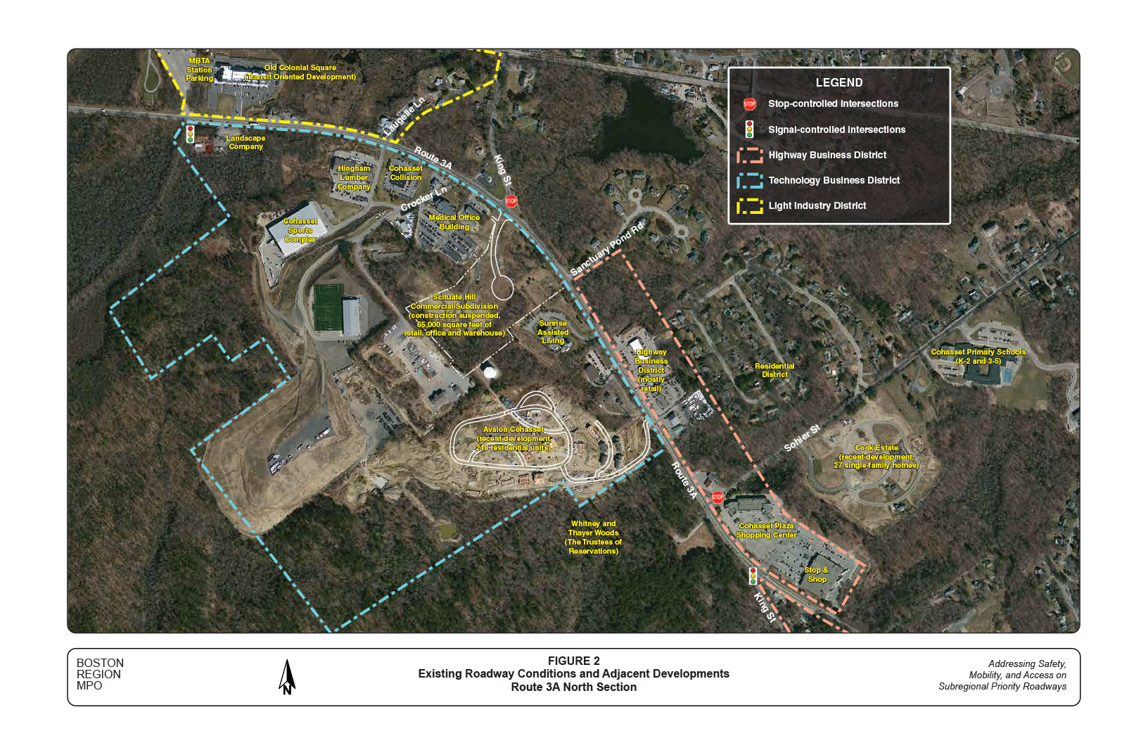
Figure 2 shows the existing roadway conditions and adjacent developments in the north section of the study corridor. The section contains two signalized intersections and two major unsignalized intersections.
The signalized intersection at Route 3A at the driveway of the MBTA Cohasset Station operates adequately because of light traffic to and from the driveway. The signalized intersection at Route 3A at King Street/Cohasset Plaza operates acceptably in general, although drivers on King Street and the peak direction of Route 3A experience some delays in the morning (AM) peak hour (detailed analyses in Section 3.3: Intersection Capacity Analyses).
Under a stop control, the side streets of the two unsignalized intersections, i.e., King Street and Sohier Street, operate unacceptably during the peak traffic hours. At times, drivers on Sohier Street experience extensive delays as a result of the surge of traffic from the adjacent primary schools and commuting traffic on Route 3A northbound.
Most adjacent areas of this section are designated as different types of business districts in the Cohasset zoning plan (Appendix B: Zoning District Map, Town of Cohasset).
The large area west of Route 3A from the intersection at the MBTA Cohasset Station to the north of Sohier Street is zoned as a Technology Business District. Major developments in the district include:
The area east of Route 3A, from the parking lot of the MBTA Cohasset Station to south of Laugelle Lane, is designated as a Light Industrial District. The major development in the district is a recently completed transit-oriented center called Old Colonial Square. The development contains 32,400 square feet of retail space and 16 residential apartments. There are also a few individual businesses located on Route 3A and Laugelle Lane in the district.
The area east of Route 3A from Sanctuary Pond Road to the existing Stop & Shop supermarket is zoned as a Highway Business District. The major development in the district is the Cohasset Plaza Shopping Center, which contains the Stop & Shop supermarket and a number of retail stores. The supermarket and the stores are only accessible via a driveway connected to the signalized intersection at Route 3A and King Street.
North of Sohier Street, the same district is segmented into a number of business subdivisions along Route 3A, which include a gas station, several retail stores (including a Dunkin’ Donuts and a few restaurants), and several business offices. The various businesses create at least eight driveways along Route 3A, in addition to three driveways from the developments on the other side of Route 3A. Route 3A in this section has a high number of crashes, most of which involve vehicles turning in and out of the adjacent developments.
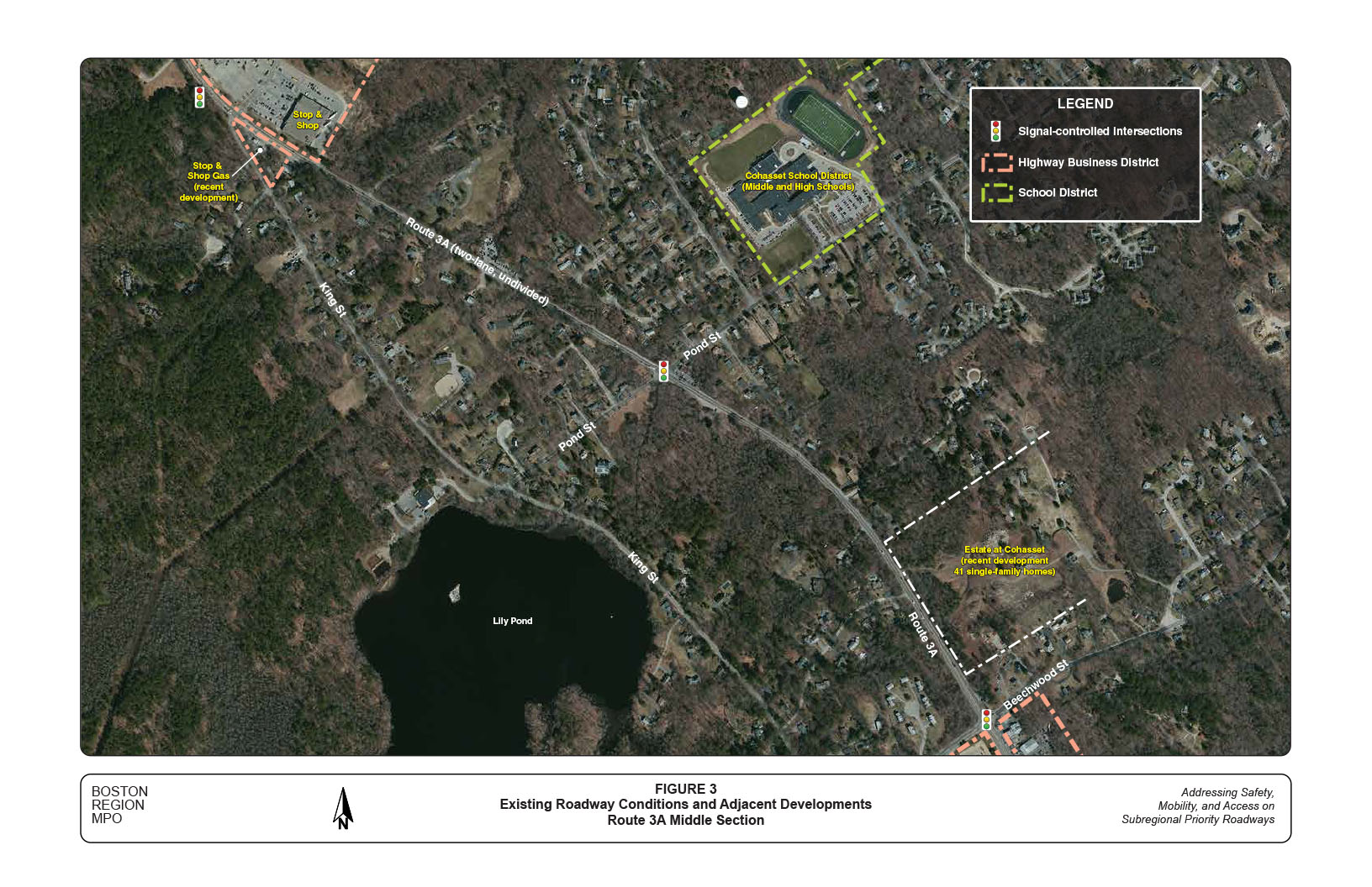
Figure 3 shows the existing roadway conditions and adjacent developments in the middle section of the study corridor. Route 3A in this section contains one signalized intersection (Route 3A at Pond Street), a few unsignalized intersections connecting to local streets, and a number of driveways (mostly from individual homes and some from businesses abutting Route 3A).
In general, the section is wooded with scattered single-family houses and a few businesses in between. Cohasset School District—located on Pond Street about 1,000 feet from Route 3A—is the major development in this section. The district contains the Town’s public middle and high schools and attracts substantial traffic during school opening and closing periods. Although the district itself is not located on Route 3A, traffic at the intersection of Route 3A at Pond Street is affected by some of the school traffic from around 7:00 to 7:30 AM.
Currently, a subdivision containing 41 upscale new homes, called Estate at Cohasset, is under construction on the east side of Route 3A between Mendel Road and Beechwood Street. The development will be accessible mainly from Beechwood Street, with emergency access that connects to Route 3A.
Because this section is less developed, vehicles tend to travel faster here than in other sections of the corridor. While they are speeding up, vehicles encounter the traffic light in the middle of the section. At the signalized intersection, Route 3A has only one lane shared by all movements in both directions. During the green lights, either approach of Route 3A can be blocked by one or two left-turning vehicles, especially in the southbound direction. This happens frequently when school opens in the morning and evening (PM) peak hours. The intersection is a high crash location. The recent five-year crash data for Route 3A indicate that the majority of reported crashes were rear-end collisions, and more than 25 percent of the crashes caused personal injuries.
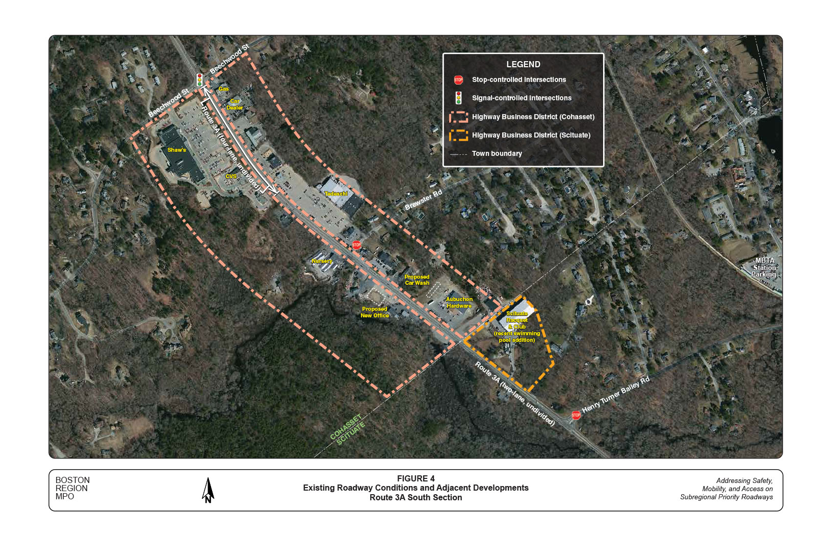
Figure 4 shows the existing roadway conditions and adjacent developments in the south section of the study corridor. This section contains mostly business districts and some vacant land.
Route 3A in this section contains a signalized intersection (Route 3A at Beechwood Street), a major unsignalized intersection (Route 3A at Henry Turner Bailey), and a large number of driveways from adjacent businesses. It also contains the only four-lane stretch (about a quarter mile south of Beechwood Street) in the entire study corridor.
In general, the signalized intersection of Route 3A at Beechwood Street operates acceptably during the day. However, according to Cohasset’s residents and businesses, it is a dangerous intersection. Crash reports for the past few years show that the intersection had a high number of crashes, with more than a quarter of them causing personal injuries. Many of them are left-turn crashes occurring at the middle of the intersection. This indicates that traffic operations at the intersection may create potential conflicts between left-turning and through traffic on Route 3A.
Under a stop control, drivers on Henry Bailey Turner Road usually have to wait a long time to enter Route 3A during peak traffic hours. According to Scituate residents, this intersection—located in an open wooded area and running downhill from either direction—also is dangerous; and vehicles on Route 3A usually travel fast when approaching the intersection.
The adjacent areas on both sides of Route 3A in this section from Beechwood Street in Cohasset to the Scituate town line are designated as Highway Business Districts in Cohasset. Across the town line, only a portion of the east side of Route 3A is zoned as a Highway Business District in Scituate (see Appendix C: Zoning District Map, Town of Scituate).
Major developments in this section include:
There are nearly 30 driveways directly connected to Route 3A from the adjacent developments. Except for the driveway from Cushing Plaza Shopping Center, most of them serve an individual or just a few neighboring developments. MassDOT 2006–10 crash data show a high number of crashes in these business districts and a crash rate higher than the MassDOT District 5 average for urban principal arterials.
In the scope meeting on March 14, 2013, representatives from the Towns, MassDOT, and MAPC shared their views of the study corridor. Below is a summary of issues and concerns:
The study advisory members discussed issues and concerns at other specific locations in the corridor, where analyses identified safety and operational problems. These issues and concerns, along with the proposed improvements, are summarized by location in Section 5 of this memorandum.
Crash data are an essential source for identifying safety and operational problems in a study area. Analyses of crash locations, collision types, time-of-day, roadway conditions, and other factors also can assist in developing improvement strategies. To obtain sufficient data for analysis, staff collected two sets of data from available resources. The two datasets are:
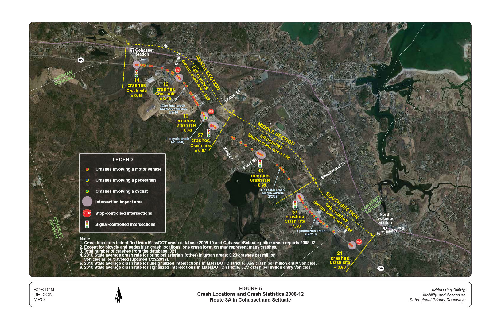
Figure 5 shows the crash locations and the crash rates at major intersections and in different sections of the corridor during the five-year period 2008–12.
The two datasets identified a total of 321 crashes. As shown in Figure 5, crashes in the study corridor mainly concentrate at intersections and in business districts.
During the five-year period 2008–12, more than 30 crashes occurred in the business district between Sanctuary Pond Road and Sohier Street in the north; and more than 50 crashes occurred in the business district between Beechwood Street and the Cohasset/Scituate town line in the south. In both districts, about 70 percent of the crashes involved a vehicle turning into or out of an adjacent business development.
The concentration of crashes in the business districts is primarily a result of 1) the lack of convenient and safe facilities for vehicles on Route 3A to access the adjacent developments, such as a left-turn-only lane or a two-way left-turn lane (TWLTL), and 2) frequent curb cuts in the business districts, which create multiple potential conflict points on the roadway with short distances in between.
Among the major intersections, those at 1) Route 3A at King Street/Cohasset Plaza Shopping Center, 2) Pond Street, and 3) Beechwood Street had a noticeably greater number of crashes than other locations. Crashes at intersections are complicated; staff further analyzed them using collision diagrams (see Section 3.4).
Figure 5 also shows the locations of a pedestrian crash and a bicycle crash. The pedestrian crash, which occurred in 2010 in the middle section of the south business district, involved a pedestrian crossing Route 3A and a vehicle traveling straight northbound. The bicycle crash occurred in 2009 near the intersection of Route 3A at Sohier Street, and involved a bicycle and a vehicle both traveling straight northbound.
Two fatal crashes occurred in the study corridor during the five-year period. One accident happened in 2010 in the north section of Route 3A near Sanctuary Pond Road; a southbound vehicle crossed the center line (reason unknown) and collided head on with a northbound vehicle. The other crash took place in 2008 in a curved area of the middle section just north of Beechwood Street; a single out-of-control vehicle crashed into a roadside embankment around midnight.
Analyses also showed that during the five-year period nearly 20 crashes at various locations in the corridor involved a deer crossing Route 3A and a vehicle traveling straight. Most noticeably, there were eight such crashes in 2012.
Crash rates are an effective metric for examining the relative safety of a particular location. The crash rate of a roadway segment is measured in terms of crashes per million miles traveled. Based on the crash datasets and the recently collected traffic volume data, staff estimated crash rates for the study area according to its three sections and their various land use characteristics, as well as for the corridor as a whole.
Based on a MassDOT official estimate (updated January 23, 2013), the 2010 State average crash rate for principal arterials in urban areas is 3.23 crashes per million vehicles miles traveled. The crash rate for the north section is slightly higher than the state average, and the crash rate for the south section is much higher than the state average. Detailed calculations of the crash rates for the three sections and for the corridor are included in Appendix D.
Crashes at intersections are measured in terms of crashes per million entering vehicles. The crash rates for four signalized intersections in the study corridor are estimated as follows:
Based on a MassDOT official estimate, the 2010 average crash rate for signalized intersections in MassDOT District 5 is 0.77 crashes per million entering vehicles. Except for the MBTA driveway intersection, the crash rates of the other three signalized intersections are all higher than the District 5 average. The crash rate of the intersection of Route 3A at Beechwood Street is about double the District 5 average.
Crash rates for the three major unsignalized intersections in the study corridor are estimated as follows:
The 2010 average crash rate for unsignalized intersections in MassDOT District 5 is estimated as 0.58 crashes per million entering vehicles. The crash rate for the intersection of Route 3A at Henry Turner Bailey Road is higher than the District 5 average. The crash rate calculations for the study intersections, in order of north to south, are included in Appendix E.
To further investigate safety and operational problems, staff summarized the crash data at the study intersections according to crash severity (property damage only, non-fatal injury, fatality, unknown), collision type (single-vehicle, rear-end, angle, sideswipe, head-on, rear-to-rear, unknown), pedestrian or bicycle involvement, time of day, pavement conditions, and light conditions. Crash statistics for the intersections, in order of north to south, are included in Appendix F. Data in both datasets (2008–10 MassDOT crash data and 2008–12 Cohasset/Scituate Police Department crash reports) were used in this analysis.
Staff also constructed collision diagrams for the study intersections based on the recent five-year crash reports provided by Cohasset and Scituate Police Departments. The collision diagrams for the intersections, in order of north to south, are included in Appendix G. Note that the number of crashes shown in the collision diagrams generally differs from the number cited in the crash statistics. This is because staff used only the police crash reports dataset—which contains detailed information about how and where the crashes occurred—to create the collision diagrams.
Major findings from the crash statistics and the collision diagrams for each of the study intersections are summarized below:
To address the major issues and concerns related to roadway operations, this section examines the existing speed controls and prevailing travel speeds, traffic volumes and flow patterns, delays at major intersections, roadway cross-sections’ accommodation of pedestrians and bicycles, and the potential for improving access to and from adjacent developments in the corridor.
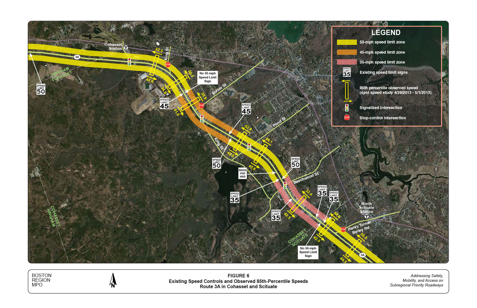
Figure 6 shows the existing speed controls and observed 85th percentile travel speeds in the study corridor. Speed limits in the corridor are regulated in three ranges: 35-, 45-, and 50-mph. Most sections of the corridor are designated as 45- or 50-mph zones, except for the business district between Beechwood Street and the Cohasset/Scituate town line, which is a 35-mph zone.
The 85th percentile speed of vehicles passing a given point is the speed at or below which 85 percent of the vehicles passing the point are traveling. It is the principle value used for establishing speed controls. The 85th percentile speeds at eight selected locations in the corridor were derived from spot speed studies performed by MassDOT for this study in spring 2013.
MassDOT procedures for speed zoning require that at speed observation locations, the established safe speed shall not be more than 7 mph below the 85th percentile speed, and not higher than the 95th percentile speed.10
As shown in Figure 6, the observed 85th percentile speeds generally conform to the safe speed requirement. The only location clearly outside the 85 percentile speed safe range is Route 3A southbound just past King Street, where the estimated 85th percentile speed is about 15 mph lower than the posted speed limit.11 The approach is slightly uphill and in a horizontal curve formation. Traffic in the section also includes some vehicles just turning onto Route 3A from King Street and thus at a lower speed.
The observed 95th percentile speeds are all within the safe speed range, as they are generally higher than 50 mph in the 45- and 50-mph zones, and at nearly 40 mph northbound and nearly 50 mph southbound in the 35 mph zone.
Overall, the 85th and 95th percentile speeds are within the required safe speed range. However, speed zone transitions in the southern half of the corridor are somewhat abrupt. There are transitions from 50 to 35 mph on Route 3A southbound just before Beechwood Street and on Route 3 northbound just past the Cohasset/Scituate town line.
The transition of 35 to 50 mph just north of Beechwood Street appears to be undesirable because of a horizontal curve and a signalized intersection located about 1,000 and 1,500 feet, respectively, ahead of the transition point.12
It appears that the 50-mph zone in the middle of the corridor could be modified to a 45-mph zone. This modification not only would smooth the speed transition but also would improve safety at the intersection of Route 3A and Pond Street (a high-crash location).
For similar reasons, MassDOT may consider further study to reduce the speed limit from 50 to 45 mph from the Cohasset/Scituate town line to Henry Turner Bailey Road.13
In addition, the speed limit around the intersection of Route 3A at King Street could be reduced from 50 to 45 mph. This modification would stipulate a travel speed that is within the safe speed range of the observed 85th percentile speed in both directions.14
Together, these modifications would bring most sections of the corridor to within a consistent 45-mph speed control, and maintain a smoother transition to or from 35 mph in the south business districts.
Note that speed regulations are complicated and require careful consideration supported by thorough engineering analyses. The proposed speed modifications should be further examined and validated according to the procedures required by MassDOT.
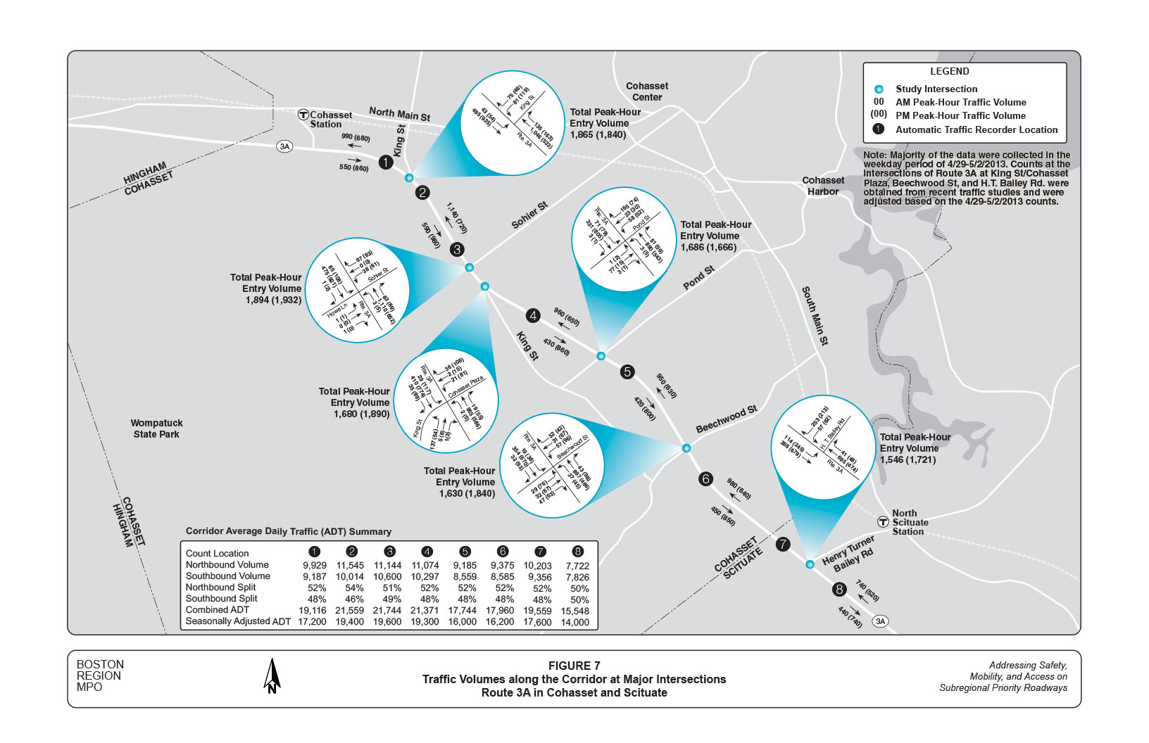
Figure 7 shows traffic volumes along Route 3A and at major intersections in the study corridor. The volumes represent recently observed traffic flows in the morning and evening peak hours of a typical weekday. As a reference, average daily traffic (ADT) volumes at eight locations in the corridor also are cited in Figure 7.
Based on traffic counts collected by MassDOT for this study, the corridor carried about 15,500 to nearly 21,500 vehicles per average weekday in spring 2013. Traffic volumes increase gradually from the south to the north section of the corridor. The variation in traffic volumes indicates that in the morning, traffic gradually feeds into the corridor from mainly Henry Turner Bailey Road, Pond Street, and King Street (the southern segment); most traffic continues on Route 3A, and some leaves the corridor at King Street (the northern leg). In the evening, the corridor has a reverse traffic pattern of a somewhat smaller magnitude.
Turning movements at major intersections in the corridor also were collected for the study; in 15-minute intervals between 7:00 to 9:00 AM and 4:00 to 6:00 PM. Traffic movements in the morning or evening peak hours were then identified and summarized for operational analyses. In general, these intersections carry a total entry traffic volume ranging from 1,550 to 1,950 vehicles per peak hour.15
It is essential to examine the proportion of heavy-vehicle traffic in a corridor, as an unusually high share of heavy vehicles (trucks and buses) may seriously affect roadway and intersection operations. Overall, the study corridor carries a normal percentage of heavy-vehicle traffic, and no concerns were expressed at meetings related to this use of the corridor.
According to the recent turning movement counts at three intersections in the corridor, heavy vehicles accounted for about 2.5-to-4.0 percent of total Route 3A traffic in the AM peak period, and 1.5-to-2.0 percent of total Route 3A traffic in the PM peak period. These heavy-vehicle percentages are considered normal, or even slightly less than average, for urban arterials in the region and would not seriously affect roadway operations.
The intersection turning movement counts also include bicycle counts and pedestrian crossings. Recent turning movement counts indicate that about two-to-five bicycles traveled on Route 3A in each of the morning and evening two-hour periods. Bicycles also were observed on Route 3A on weekends, as the roadway is adjacent to coastal and nature areas. Cohasset has designated North/South Main Street as a bike route. Depending upon their origins and destinations, some bicyclists still use Route 3A in this area.
The turning movement counts do not show large numbers of pedestrian crossings at the major intersections in the corridor. In general, about zero- to one-or-two pedestrians were observed during the morning or evening peak period. The scarce pedestrian activity may be a result of the lack of sidewalks and safe crossing facilities in the study corridor.16 According to the Cohasset town officers, pedestrian crossings on Route 3A, especially in business districts, were observed from time to time.
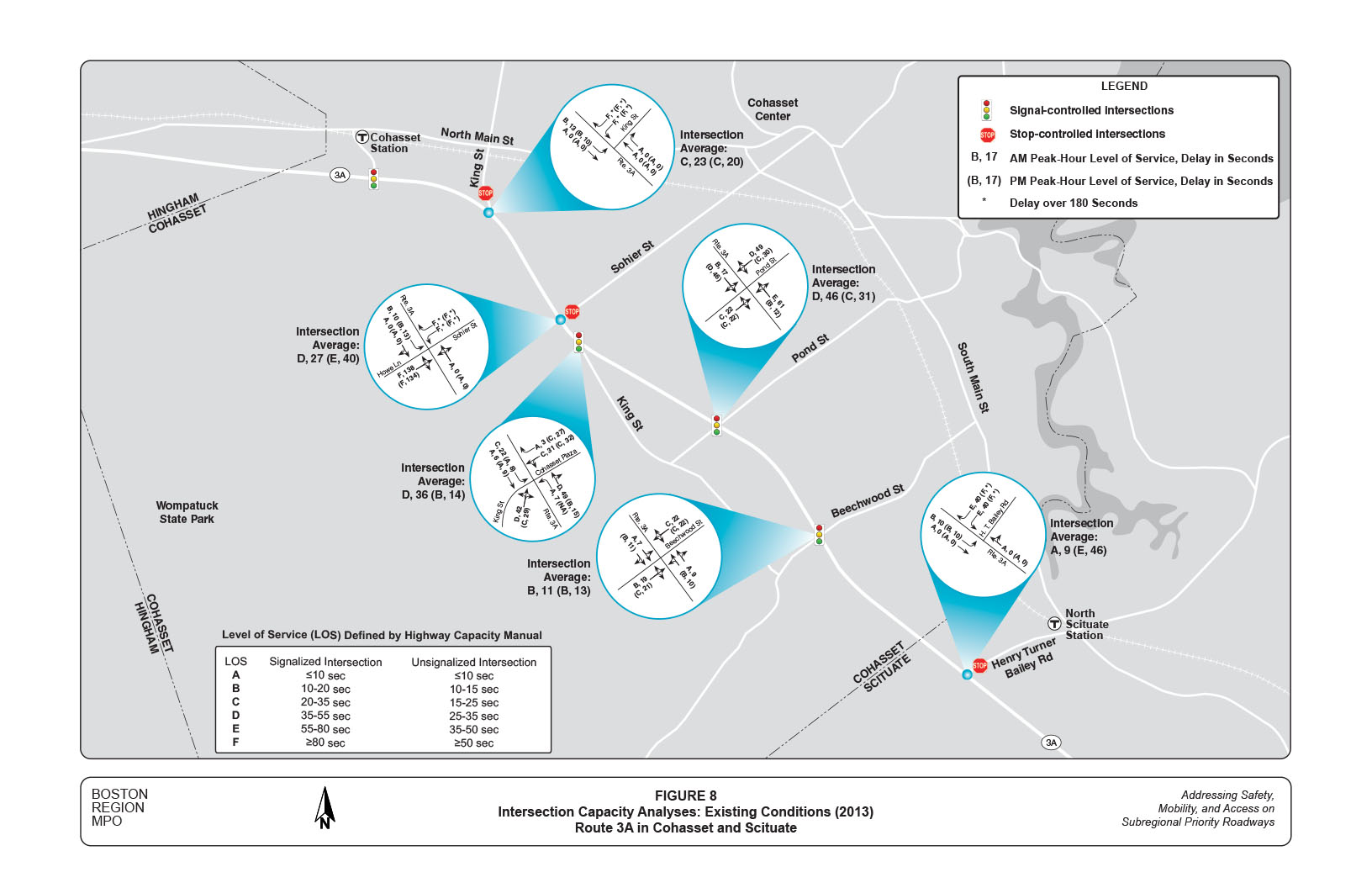
Figure 8 shows the estimated levels of service (LOS) and delays at major intersections in the corridor based on recent turning movement counts. These were analyzed for all approaches, and for the average of a study intersection in the AM and PM peak hours. Staff performed the analyses using Synchro computer software.17 Figure 8 also cites definitions of the different LOS, based on estimated average delays per vehicle, for signalized and unsignalized intersections.
In general, the signalized intersections in the study area operate at desirable or acceptable LOS. In the off-peak direction, i.e., southbound in the morning and northbound in the evening peak hour, Route 3A approaches generally operate at desirable LOS ranges (LOS A or LOS B). In the peak direction, i.e., northbound in the morning or southbound in the evening peak hours, Route 3A approaches generally operate acceptably (LOS C or LOS D), except for the northbound approach at Pond Street. This approach, which contains a single travel lane for all movements, operates at LOS E in the morning peak hour.
In general, the side streets of the signalized intersections operate acceptably. The analyses indicate that two locations endure slightly more delays than other locations in the AM peak hour: the northbound approach of King Street at the Cohasset Plaza Shopping Center and the southbound approach of Pond Street at Route 3A. The northbound movement on King Street carries heavy commuter traffic in the morning, and the southbound on Pond Street is especially congested between 7:00-to-7:30 AM when school opens.
The capacity analyses for the unsignalized intersections indicate that the side streets of these intersections generally operate at undesirable LOS E or LOS F with extensive delays. These analyses confirm residents’ concern about delays at the three major unsignalized intersections in the corridor.
In addition, staff performed a preliminary traffic signal warrant analysis for each of the three unsignalized intersections, which is a basic requirement to justify installing a traffic signal at an unsignalized intersection.
The warrant analyses indicate that all three unsignalized intersections are suitable for installation of a traffic signal. Summaries of the analyses of applicable warrants are shown in Appendix H. Note that these are preliminary analyses based on the available traffic counts and crash data, and further engineering studies based on more detailed and updated data are needed in order to justify the signal installation.
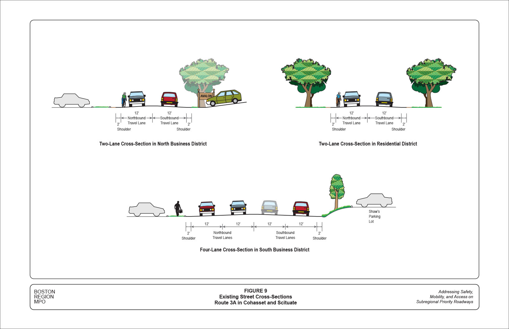
Figure 9 shows typical roadway cross-sections in different segments of the study corridor, presenting street views looking south by a southbound driver. The two-lane roadway sections generally contain a 12-foot travel lane in each direction with a 2-foot shoulder.18 The four-lane section, referring to the section of about a quarter mile south of Beechwood Street, contains two 12-foot travel lanes in each direction with a 2-foot shoulder.
The fact that there are no sidewalks in the entire study corridor also can be seen in Figure 9. Even in the business districts, pedestrians need to walk on the edge of parking lots adjacent to Route 3A; and customers usually need to drive in order to move from one shopping plaza to another. Crossing Route 3A is challenging to pedestrians as well. In the corridor, crosswalks exit at three locations only: Route 3A at Sohier Street, Pond Street, and Beechwood Street.
The corridor does not contain a separate lane or sufficient shoulder for bicycle travel. Although no pavement markings or traffic signs clearly indicate the corridor as a shared roadway, it is regarded as one since bicycles are not prohibited in of any sections in the corridor.19 However, such a shared roadway usually is perceived as unsafe because the prevailing traffic speed is greater than 45 mph.
In the business districts under either the two- or four-lane configuration, there is no exclusive space, such as a left-turn-only lane or a two-way left-turn lane, for vehicles traveling on Route 3A to access adjacent developments. In the two-lane sections, left-turning vehicles usually block the entire roadway if the opposite traffic is heavy. In the four-lane sections, left-turning vehicles need to cross two lanes of traffic that often obstruct the other’s view.
In addition, frequent curb cuts in the business districts create multiple conflict points on the roadway with short distances in between. Some of the driveways in the business districts have the potential for consolidation, which to be effected would require collaborative efforts from adjacent businesses, the Towns, and MassDOT.
The crash data analyses in Section 3 indicate that the business sections of the corridor have a high number of crashes and a higher-than-State-average crash rate, especially in the four-lane business section. Improvements to the access to adjacent business from Route 3A would make the roadway safer for all users.
A directive of MassDOT is that urban arterials should be designed to serve all individual roadway users, including pedestrians, cyclists, and transit riders, under either separate or shared accommodations.20 This section explores opportunities for “complete-street” applications to address the lack of pedestrian and bicycle accommodations in the study corridor. It also examines whether access to and from adjacent businesses on Route 3A could be improved by modifying the existing roadway configuration.
The corridor has a right-of-way ranging from 40 to 70 feet. The majority (nearly 70 percent) of the corridor has a 50-foot right-of-way, consisting of the area from the MBTA Cohasset Station to King Street (northern segment) and the Cohasset Plaza Shopping Center to the Cohasset/Scituate town line. The section from King Street to the Cohasset Plaza has a right-of-way of 40 feet. The section from the town line to Henry Turner Bailey Road has a right-of-way of 70 feet. These dimensions are ample enough to potentially install sidewalks, widen shoulders, and add traffic medians or left-turn lanes at suitable locations.21
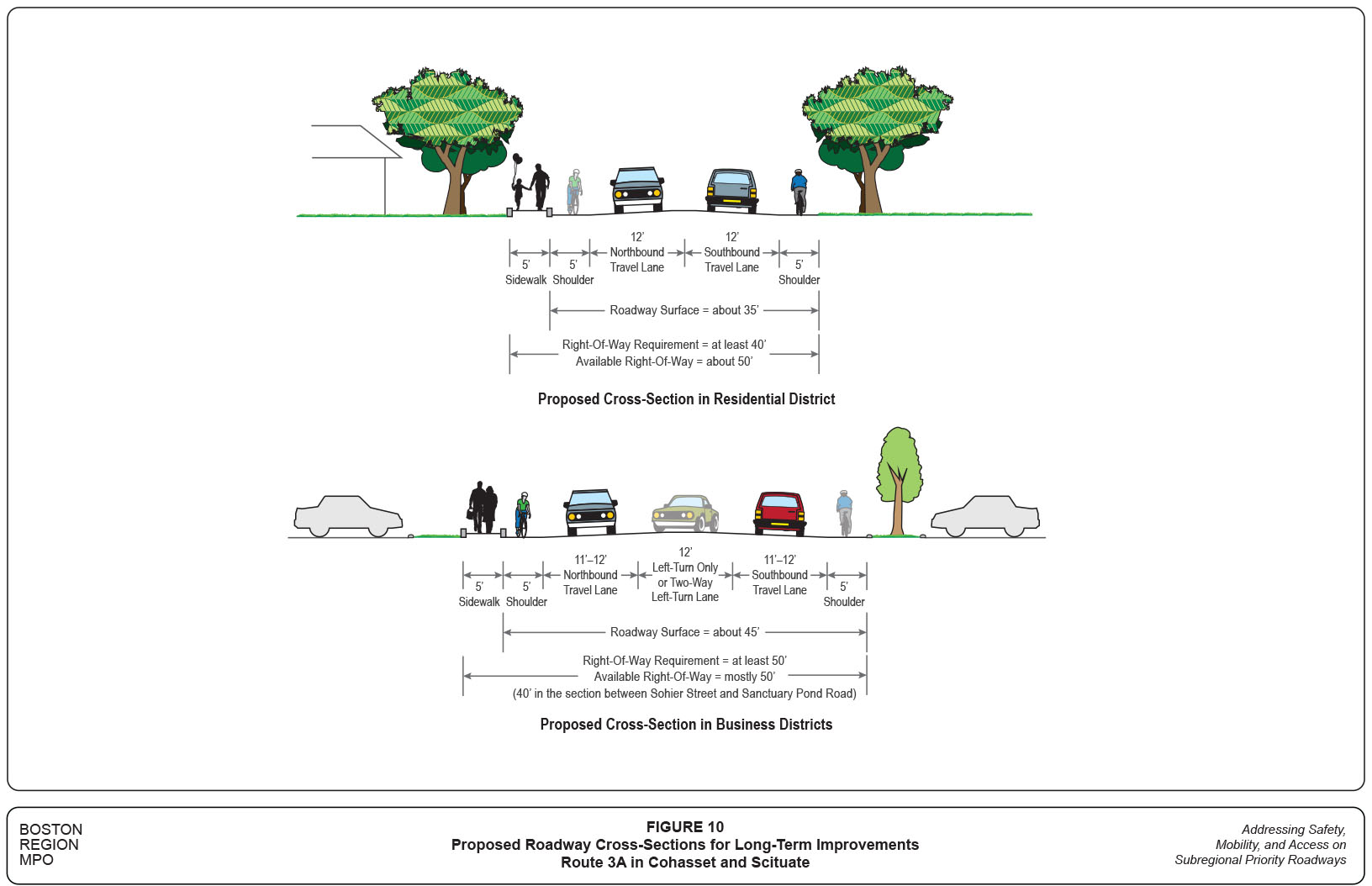
Figure 10 shows the proposed roadway cross-sections in the residential and business districts of the corridor. These contain three major components over the existing roadway configurations:
The sidewalks would provide non-motorized accesses to the businesses, conservation areas, and the MBTA Cohasset commuter rail station. In the business districts, sidewalks can be considered on both sides of the roadway.
The 5-foot shoulders would provide accommodation for bicycles and a sufficient buffer between traffic and pedestrians. On the west side of the roadway, they also could offer occasional access for pedestrians, although most houses are located on the roadway’s east side. Preferably, these 5-foot wide shoulders could be extended beyond the study corridor to connect major destinations in the area.22
The central lane on Route 3A would provide access to the adjacent developments and maintain a safe traffic flow on Route 3A. Depending on the adjacent development needs, the central lane could be a combination of left-turn only, two-way left-turn, or traffic median. This roadway design is suitable for urban arterials with various types of adjacent developments. In the study corridor, the central lane could be appropriated by adding a lane in the two-lane sections and reducing a lane in the four-lane sections.
It would require a right-of-way of about 50 feet to accommodate the three major modifications. Most sections of the corridor should be able to accommodate the modifications, except for the 40-foot right-of-way business section between Sanctuary Pond Road and the Cohasset Plaza Shopping Center. Currently, both sides of this section are composed of lawns, with no major fixed structures. The potential land takings of about 5 feet on each side of the roadway would not affect existing building and parking layouts.
Based on the preceding analyses, staff developed short-, medium-, and long-term suggested improvements for the study corridor. Their implementation horizons are defined as:
The short-term improvements may be implementable in a brief timeframe with relatively low costs. The medium-term improvements are options that require further engineering analyses and designs, and likely would involve more time and resources than the short-term improvements. The long-term improvements generally are more complicated and cover a large area, which would require intensive planning and design efforts and funding resources.
Table 1 summarizes the proposed short-, medium-, and long-term improvements for the north section of the study corridor, with issues and concerns listed for reference. They are arranged according to the roadway section in general, and by specific location, from north to south.
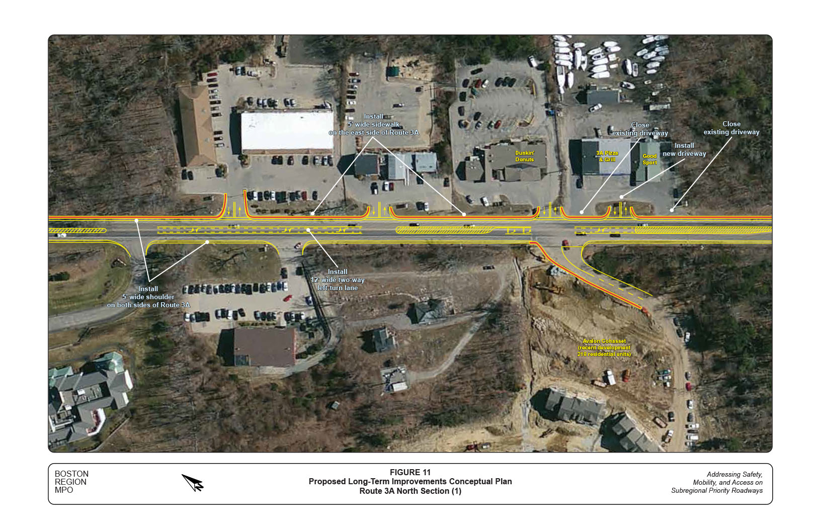
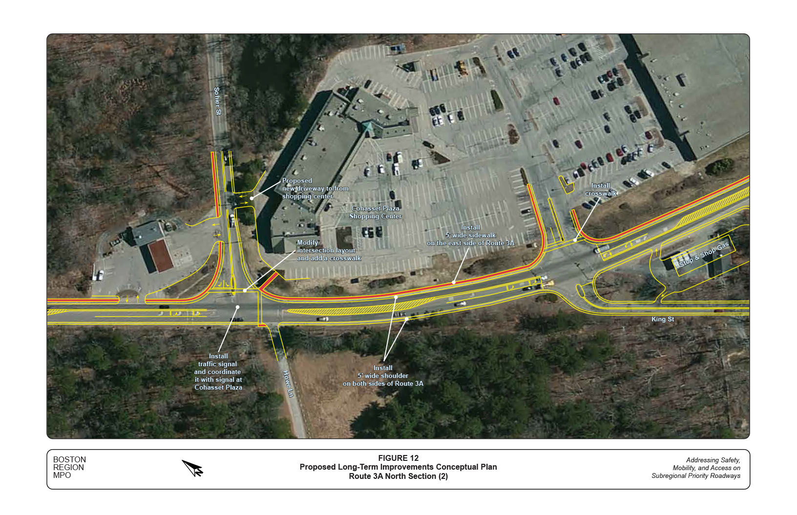
Figures 11 and 12 show the locations and layouts of the proposed long-term improvements in two parts of a conceptual plan for the north section of the study corridor. The conceptual plan was not created to scale, but in approximate proportion, in order to show how the proposed improvements would relate to their surroundings.
For the north section in general, three major long-term improvements are proposed:
The proposed three-lane Route 3A section would provide safe access to adjacent developments and maintain continuous traffic flow.
Note that the section of Route 3A between the MBTA Cohasset Station and King Street is not explicitly shown in the conceptual plan, as the adjacent areas potentially would contain future redevelopments and the layouts are unknown. The areas, currently zoned as Technology Business District and Light Industrial District, house a number of older developments and vacant lands; hence have the potential to be combined and redeveloped. However, the concepts and layouts of the proposed improvements for the section between Sanctuary Pond Road and Sohier Street (Figure 11) also could be applied to this area.
Residents at the Avalon Cohasset raised the concern that there is no crosswalk to access businesses on the other side of Route 3A. The current traffic and pedestrian crossing conditions probably do not meet the warrants for installing a traffic signal specifically for pedestrian crossings; but the location may be suitable for installing a crosswalk with pedestrian hybrid beacons. However, a detailed engineering study with more detailed and updated data should be performed to examine the feasibility of such an installation. Information and guidelines for the installation of pedestrian hybrid beacons are included in Appendix I.23
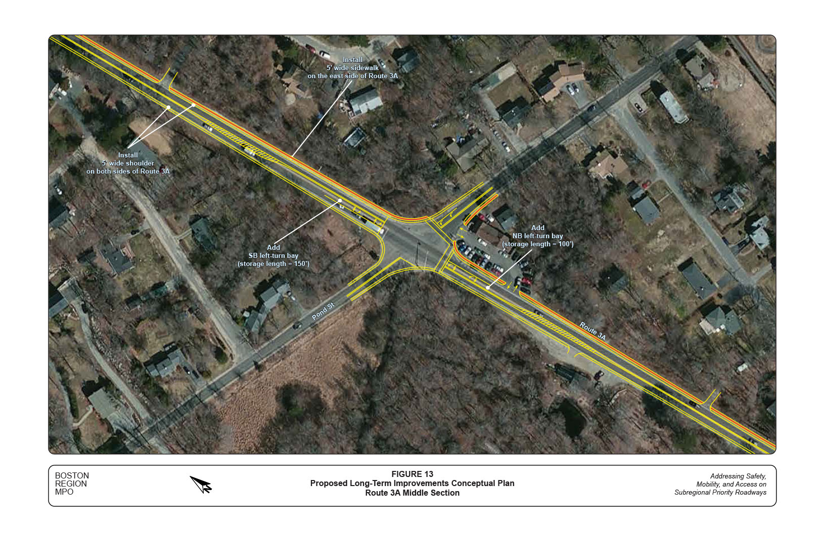
Table 2 summarizes the proposed short-, medium-, and long-term improvements for the middle section of the study corridor, with issues and concerns listed for references.
The middle section mainly consists of residential districts and vacant woodlands. For the section in general, two major long-term improvements are proposed:
In addition, a major reconstruction of the intersection of Route 3A at Pond Street is proposed in order to address safety and operational problems at the location.
Figure 13 shows the conceptual plan for the proposed long-term improvements in the vicinity of this intersection.
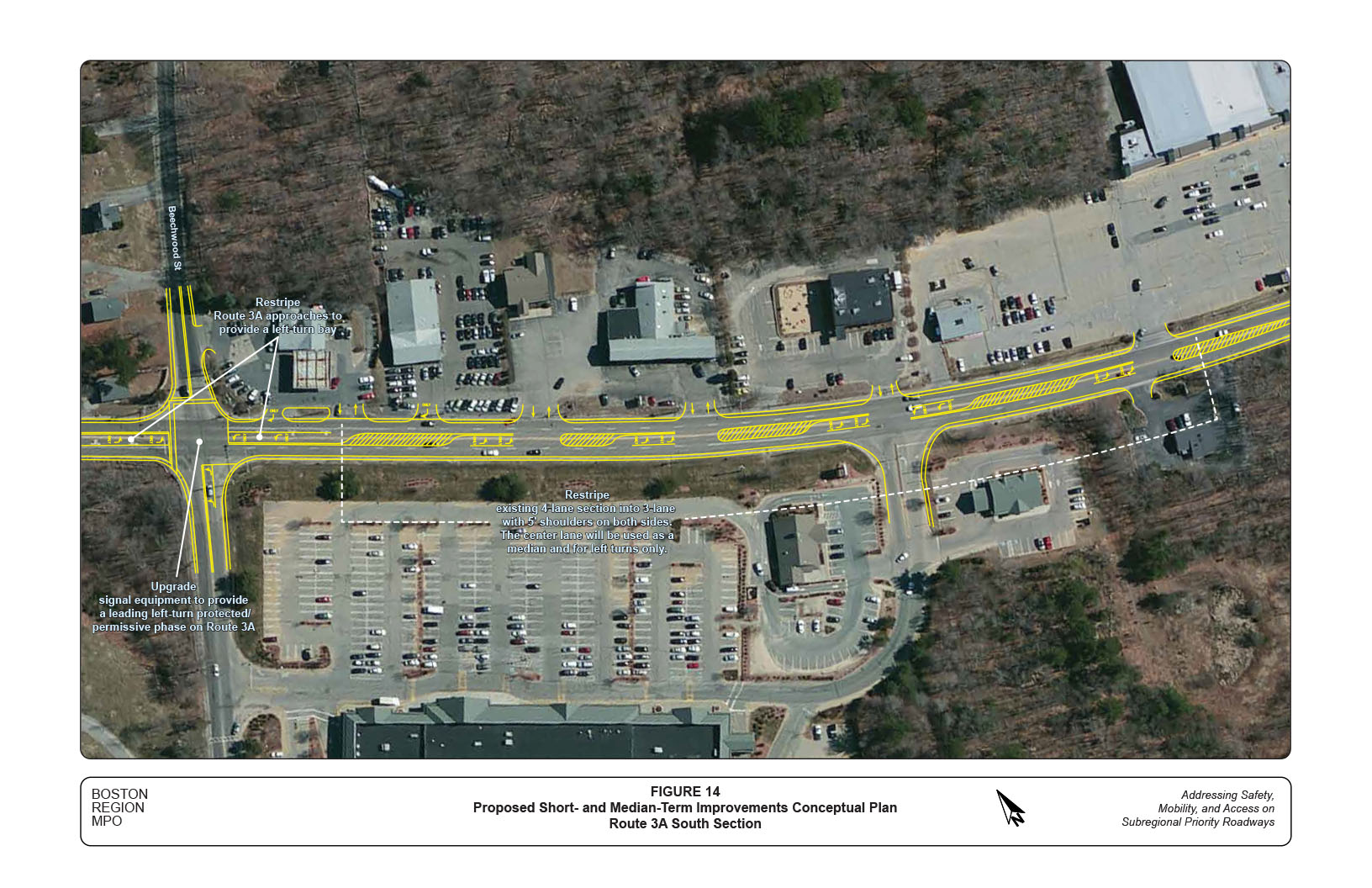
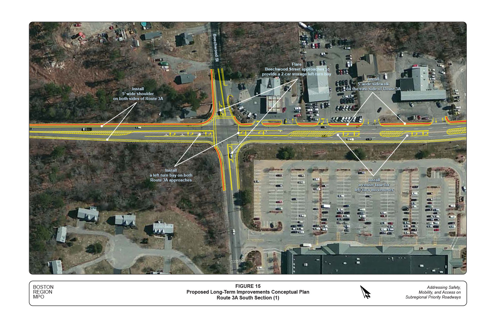
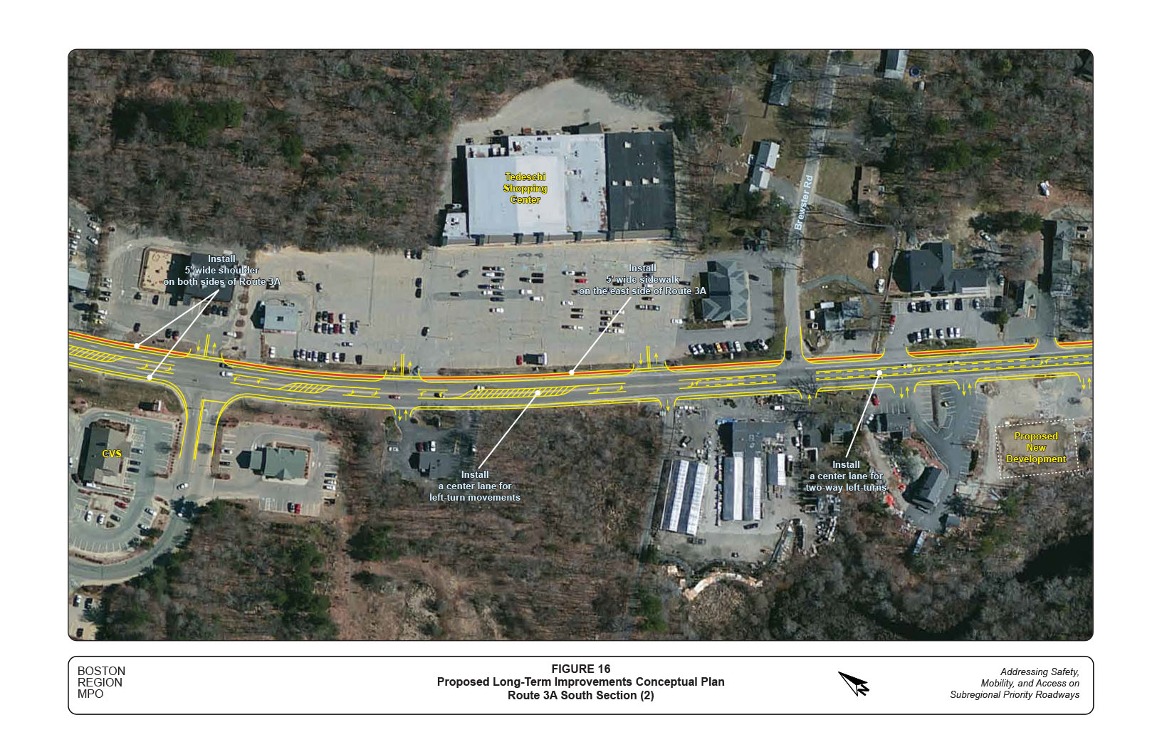
Table 3 summarizes the proposed short-, medium-, and long-term improvements for the south section in the study corridor, with issues and concerns listed for references.
For the section in general, three major long-term improvements are proposed:
The center lane of the three-lane roadway would be configured as a traffic median, a left-turn-only lane, or a two-way left-turn lane depending on the adjacent business settings. The proposed improvements would provide safe access to adjacent developments and maintain continuous traffic flow on Route 3A. However, some consolidations or modifications of adjacent driveways could be required for the center lane to function safely and efficiently.24
In addition, a major reconstruction of the intersection of Route 3A at Beechwood Street is proposed in order to address safety and operational problems at the location.
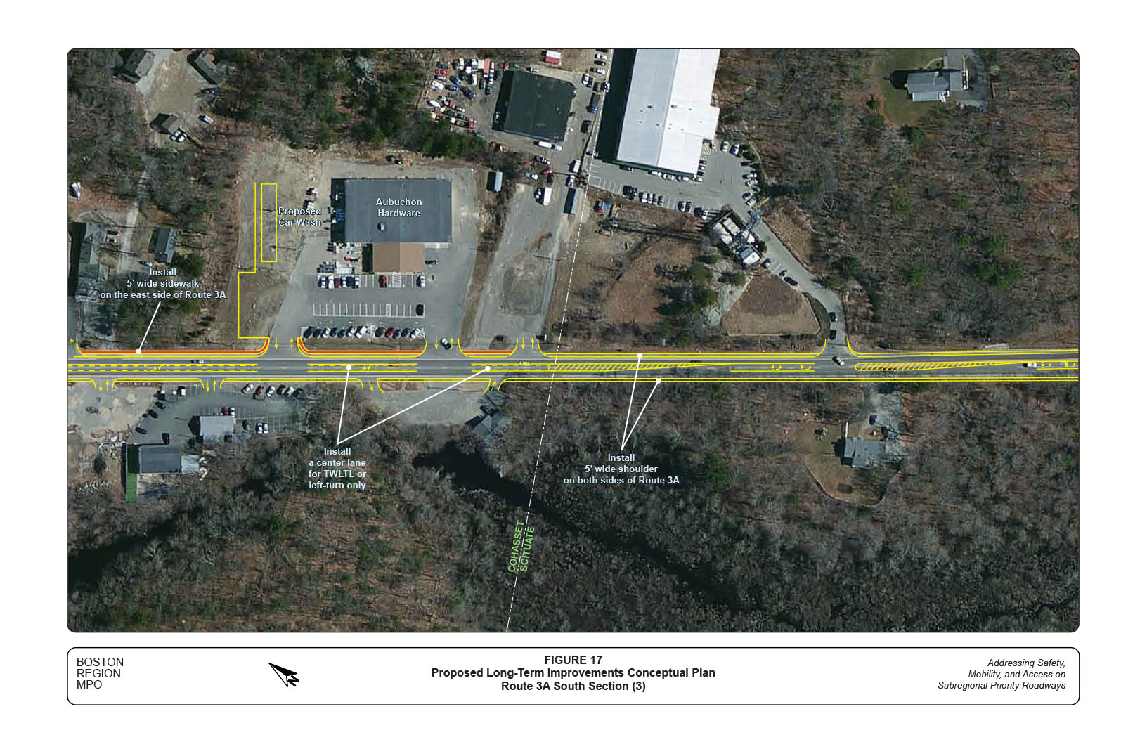
Figure 14 shows the proposed medium-term improvements for the Beechwood Street intersection and the section south of Beechwood Street. Figures 15, 16, and 17 show the proposed long-term improvements for the all the business districts in four parts of a conceptual plan for the south section.
Sidewalks also should be considered on the west side of Route 3A if the right-of-way on that side is available for the business districts south of the Cushing Plaza Shopping Center. At the roadway functional design stage, potential crosswalk locations should be examined for the purpose of connecting the businesses on both sides of Route 3A.
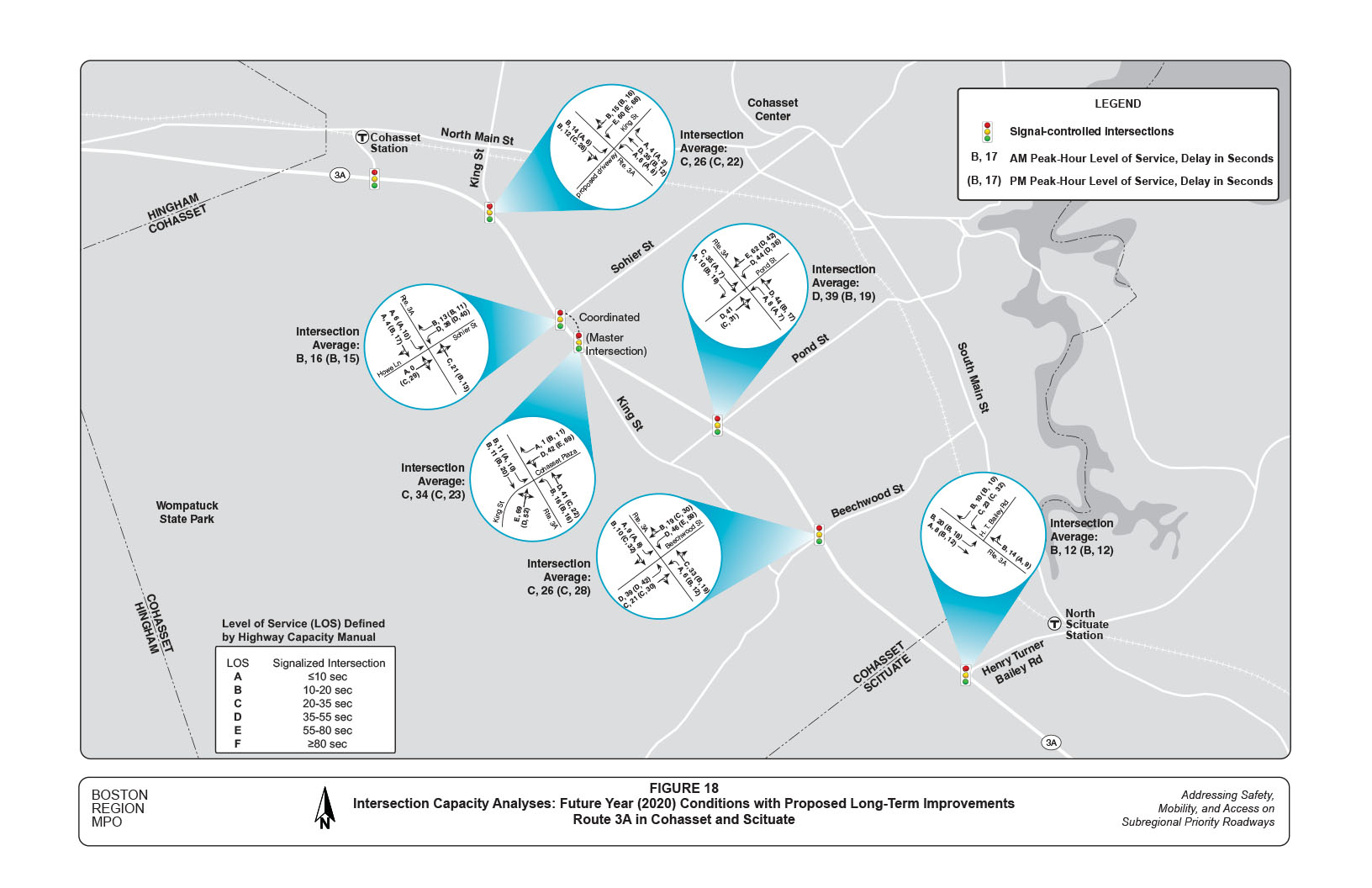
In summary, with the proposed long-term improvements in the north, middle, and south sections of the study corridor, all intersections are expected to operate at a desirable or acceptable LOS under the projected 2020 traffic conditions (Figure 18). Analysis of the Beechwood Street intersection indicates that conversion of the four-lane section into a three-lane roadway would not seriously affect traffic operations on Route 3A. 25
This study performed a series of safety and operations analyses, identified safety and operational problems, and proposed a number of short-, medium-, and long-term improvements to address the identified problems in the study corridor. Altogether, the long-term improvement conceptual plans provide a vision that would accommodate all users and significantly enhance safety, mobility, and access in the corridor.
Below is a summary of major benefits expected from the proposed improvements:
Implementing the proposed improvements would require sufficient resources and cooperation. The staff proposes the following implementation priorities for consideration:
After the second advisory meeting, the Cohasset Planning Board met with Town residents and business owners to discuss the issues and solutions for the corridor based on preliminary findings and proposed improvements. Comments from residents and business owners are included in Appendix J.
In conclusion, the corridor would benefit from a consensus vision for long-term improvements and a comprehensive access management program. This would require a collaborative effort from adjacent developments, the Towns, and MassDOT to ensure that the corridor operates safely, efficiently, and sufficiently for all users in all transportation modes.
CW/CW/cw
TABLE 1
Proposed Improvements in North Section
Route 3A from MBTA Cohasset Station to Cohasset Plaza Shopping Center
Location |
Issues/Concerns |
Short- and Medium-Term Improvements* |
Long-Term Improvements |
|---|---|---|---|
The section in general |
|
|
|
Intersection: Route 3A at MBTA Cohasset Station |
|
|
|
Intersection: Route 3A at King Street |
|
|
|
Intersection: Route 3A at Sohier Street |
|
|
|
Intersection: Route 3A at King Street/Cohasset Plaza Shopping Center |
|
NA |
|
Mph Miles per hour. N/A Not available or applicable. TWLTL two-way left-turn lane.
* Unless noted as “medium-term,” the proposed items are considered to be short-term.
TABLE 2
Proposed Improvements in Middle Section
Route 3A from South of Cohasset Plaza Shopping Center to North of Beechwood Street
Location |
Issues/Concerns |
Short- and Medium-Term Improvements* |
Long-Term Improvements |
|---|---|---|---|
The section in general |
|
|
|
Intersection: Route 3A at Pond Street |
|
|
|
Mph Miles per hour. N/A Not available or applicable. TWLTL two-way left-turn lane.
* Unless noted as “medium-term,” the proposed items are considered to be short-term.
TABLE 3
Proposed Improvements in South Section
Route 3A from Beechwood Street in Cohasset to Henry Turner Bailey Road in Scituate
Location |
Issues/Concerns |
Short- and Medium-Term Improvements* |
Long-Term Improvements |
|---|---|---|---|
The section in general |
|
|
|
Intersection: Route 3A at Beechwood Street |
|
|
|
Intersection: Route 3A at Henry Turn Bailey Road |
|
|
|
Mph Miles per hour. N/A Not available or applicable. TWLTL two-way left-turn lane.
* Unless noted as “medium-term,” the proposed items are considered to be short-term.
1 The study work program was approved on December 6, 2012. The other selected corridor is Routes 127A/127 in Gloucester and Rockport, and findings for that corridor are reported in a separate memorandum.
2 Boston Region Metropolitan Planning Organization, Unified Planning Work Program, Federal Fiscal Year 2013, Endorsed by the Boston Region Metropolitan Planning Organization on June 28, 2012.
3 Geographic equity among subregions was also considered in this criterion.
4Selection of Study Locations: Addressing Safety, Mobility, and Access on Subregional Priority Roadways, Memorandum to Boston Region MPO, Chen-Yuan Wang, February 7, 2013.
5 Twenty-nine crashes occurred in the middle of the intersection. Ten of them involved a southbound left-turning vehicle and a northbound through vehicle, and seven of them involved a northbound vehicle and a southbound through vehicle.
6 Currently the left turners are detected by a single six-by six-foot loop covering only a small area on the stop line. If a left-turning vehicle stops beyond the stop line or too far from the stop, it will not be detected by the detector loop. Especially in the southbound section, vehicles tend to move beyond the stop line when they are seeking the scarce gaps under heavy traffic conditions.
7 The “trap” can happen when the left turners use the yellow change interval but fail to pass out of the intersection before the opposite through traffic arrives or when they are confused about the green ball and fail to yield to the opposite through traffic.
8 Under the configuration, a left-turn driver’s view of the through traffic on the opposite outside lane can be obstructed by left-turning vehicles on the other approaches of Route 3A. A driver on the outside lane can be prevented from seeing the opposite left-turning traffic by vehicles stopping on the adjacent inside lane.
9 Fifteen crashes involved a through vehicle on Route 3A and a vehicle-turning vehicle in or out of the gas station.
10 Procedures for Speed Zoning on State and Municipal Roadways, MassDOT Highway Division, May 2012.
11 Note that the 85th percentile speeds for this planning study were derived from spot speed data collected from automatic traffic reorders. To establish or modify speed controls, MassDOT requires speed data collected by using radar gun or laser gun at critical locations not to exceed 0.25 miles, in addition to vehicle trial runs in the study area.
12 Although crashes in this section of 50-mph zone are not as numerous as those in business districts, they are generally more severe and likely would cause personal injuries. There was a fatal crash in this section in 2008.
13 Although officially the section is regulated as a 50-mph zone, there is no speed limit sign on Route 3A southbound at the town line to indicate the speed limit change. Without the sign, drivers on the approach may assume that they still are under a 35-mph speed control. This reflects in the observed 85th percentile speed, which is much lower than 50 mph in a relatively straight section. It is actually favorable to maintain this low speed in the section, as vehicles travel downhill toward the Henry Turner Bailey Road intersection where other vehicles may enter Route 3A unexpectedly.
14 Although officially the section is regulated as a 50-mph zone, there is no speed limit sign on Route 3A northbound before the intersection to indicate the speed limit change. Without the sign, drivers on the approach may assume that they still are under a 45-mph speed control. It is actually helpful to maintain a low speed in this section, as drivers are in a curve and slightly downhill approaching the King Street intersection where their sight distances are limited.
15 Turning movement counts at the intersection of Route 3A at the driveway of the MBTA Cohasset Station were not collected, as the location generally operates desirably without noticeable delays.
16 In the corridor, crosswalks exist only at the intersections of Route 3A at Sohier Street, Pond Street, and Beechwood Street. Pedestrian push buttons exist only at the intersections of Route 3A at Pond Street and Beechwood Street.
17 Synchro Version 8 is developed and distributed by Trafficware Ltd. The software can perform capacity analysis and traffic simulation (when combined with SimTraffic) for an individual intersection or a series of intersections.
18 Some sections in the residential districts contain shoulders less than two feet wide.
19 As bicyclists are legally able to use nearly all roadways, most of them can be technically classified as shared roadways. The exception for shared roadways are where bicycling has been expressly prohibited by an ordinance or law, such as in city streets or access-controlled freeways in some states. However, many of these shared roadways have no provisions for bicycle travel and are perceived by bicyclists to be unsafe or at least uninviting.
20 MassDOT Project Development and Design Guide, January 2006, Massachusetts Department of Transportation.
21 These approximate right-of-way data were obtained from the MassDOT Roadway Inventory File for this planning study. Further review of the assessor’s plots should be conducted at the functional stage.
22 Based on the MassDOT Project Development and Design Guide, five feet is the minimal width requirement to accommodate bicycle travel. If right-of-way is available, six feet would be preferable.
23 The pedestrian hybrid beacon is a pedestrian-activated warning device located on the roadside or on mast arms over midblock pedestrian crossings. The beacon head consists of two red lenses above a single yellow lens. The beacon head is “dark” until the pedestrian desires to cross the street. At this point, the pedestrian will push an easy-to-reach button that activates the beacon. After displaying brief flashing and steady yellow intervals, the device displays a steady red indication to drivers and a WALK indication to pedestrians, allowing them to cross a major roadway while traffic is stopped. After the pedestrian phase ends, the WALK indication changes to a flashing orange hand to notify pedestrians that their clearance time is ending. The hybrid beacon displays alternating flashing red lights to drivers while pedestrians finish crossing before going dark once again at the conclusion of the cycle.
24 The center lane is intended for turning movements only, not for continuous vehicle travel. It should be designed in concert with the adjacent parking and driveway settings by carefully applying it as a traffic median, left-turn-only, or two-way left-turn in appropriate lengths.
25One percent traffic growth per year was assumed for 2020 traffic conditions at the study intersections.
Appendices
Below is a description of the appendices that are attached to this memorandum. Because they are images, these appendices are not in accessible format. However, they can be viewed in the PDF version of the memorandum.
APPENDIX A.
Appendix A is a list of participants for the study advisory meetings from March 14, 2013 and September 5, 2013.
APPENDIX B.
Appendix B is a zoning district map Town of Cohasset.
APPENDIX C.
Appendix C is a zoning district map of the Town of Scituate.
APPENDIX D.
Appendix D consists of the following four segment crash rate worksheets from the Massachusetts Department of Transportation (MassDOT):
APPENDIX E.
Appendix E consists of the following seven intersection crash rate worksheets from the Massachusetts Department of Transportation (MassDOT):
APPENDIX F.
Appendix F consists of the following seven tables, which cite intersection crash statistics compiled from MassDOT crash data, 2008–10 and Cohasset police crash reports, 2010–12. Each table consists of 19 rows and 8 columns:
APPENDIX G.
Appendix G consists of the following seven intersection collision diagrams from the Town of Cohasset police reports during the period January 1, 2008 through March 31, 2013:
APPENDIX H.
Appendix H consists of the following three preliminary traffic signal warrants analyses, which are in the form of tables that are not formatted for accessibility:
APPENDIX I.
Appendix I consists of a reproduction of a six-page newsletter called Baystate Roads Program—Local Technical Assistance Program (LTAP) TECHnotes, which contains information and guidelines about the Pedestrian Hybrid Beacon device.
APPENDIX J.
Appendix J contains the Route 3A study comments collected by the Cohasset Project Management and Planning Department as of November 5, 2013. The 42 comments are presented in the form of a two-page text table.