Top Stories
For the most recent information on the following public meetings and others that may have been scheduled after TRANSReport went to press, go to www.bostonmpo.org or call (617) 973-7119. A photo ID is required to access most meeting sites.
A recent study, supported by the Boston Region Metropolitan Planning Organization (MPO), presents recommendations for ways to reduce congestion at bottleneck locations on Interstate 93 southbound in Woburn and Stoneham, and Interstate 95 southbound in Weston. The Low-Cost Improvements to Express Highway Bottleneck Locations study is the third in a series that identify low-cost options for mitigating recurring traffic congestion on the region’s roadways.
The Federal Highway Administration estimates that as much as forty percent of recurring congestion on the nation’s highways is attributable to bottlenecks. Bottlenecks are locations where, because of physical design constraints or operational conflicts, the roadway is unable to process high volumes of traffic that occur routinely and predictably. This results in traffic queues approaching the bottleneck with free-flowing traffic beyond that point. Bottlenecks often occur at locations where traffic merges or weaves, where there are lane reductions, and at major interchanges with large volumes of traffic passing from one highway to another.
At Interstate 93 in Woburn and Stoneham, for example, large volumes of traffic enter the highway at Exit 37 and leave at Exit 36 to Montvale Avenue, which slows traffic on the main section of the highway. In addition, the deceleration lane at Exit 36 is too short, which contributes to a significant number of crashes where traffic diverges from the mainline.
To address congestion and safety at this location, MPO staff—working with the Massachusetts Department of Transportation (MassDOT)—proposed two alternatives. The MPO staff’s recommended solutions are to 1) create an auxiliary lane between Exits 37 and 36, which would improve traffic flow by taking merging and diverging traffic out of the mainline and providing an exit-only lane for Exit 36; and 2) construct an emergency pullover area.
At Interstate 95 in Weston, bottlenecks occur at the interchanges with Interstate 90 and Route 30. The one-lane acceleration and deceleration lanes on entrance and exit ramps are not designed to handle the amount of traffic traveling on and off Interstate 95 at peak travel times. These bottlenecks cause queues to form on the Interstate 90 connector, slow mainline traffic on Interstate 95, and result in a large number of crashes.
Alternatives for addressing these bottlenecks include creating an exit-only ramp at Exit 25 on Interstate 95, potentially with a two-lane exit ramp. In addition, between Exit 25 and the entrance ramp from Interstate 90, the through-traffic lanes could be reduced from four to three in order to create an auxiliary lane for traffic entering from Interstate 90. MassDOT is moving ahead with improvements to this location and will be implementing some the recommendations from this study.
To learn more about the proposed improvements, see the Low-Cost Improvements to Express Highway Bottleneck Locations: FFY 2015 report on the MPO’s website, www.bostonmpo.org.
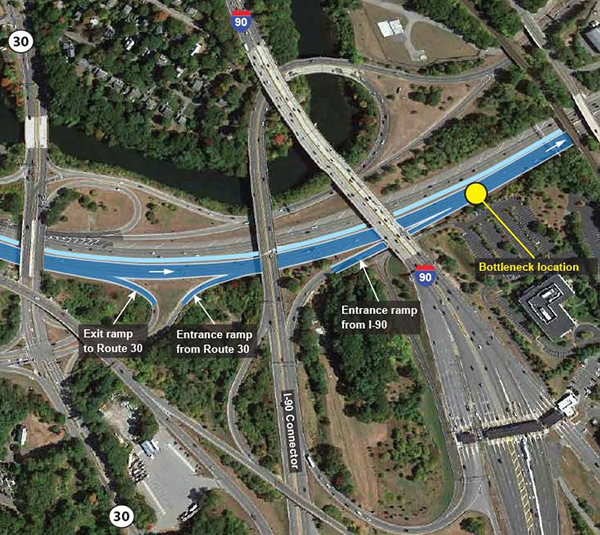
MassDOT is implementing recommendations from an MPO-supported study to address bottlenecks on Interstate 95 southbound between Exit 25 and Recreation Road in Weston. [Photo: Google Earth]
Seniors and people with disabilities looking for transportation options may turn to a new database made available by the Boston Region MPO that catalogs transportation service providers in the Boston region’s 101 municipalities.
The Senior Transportation Services Database lists services provided by councils on aging, regional transit authorities, elder affairs offices, and other non-profit and private organizations.
The database is searchable by city or town and provides data about each service provider, including contact information, amount of notice required for reservations, hours of operation, fees, and age restrictions. It also cites information about the types of trips served (such as for medical appointments or grocery shopping, for example), destinations, and wheelchair accessibility.
The Senior Transportation Services Database is available on the MPO’s website.
Next Story • Previous Story • Back to Top
MPO Votes on Amendments to the Transportation Improvement Program
The Boston Region MPO took action in January to amend the federal fiscal years (FFYs) 2016–20 Transportation Improvement Program (TIP). On January 7, the MPO voted to approve Amendment One of the TIP following a public review period. This action authorized spending $5.4 million for the Tri-Community Bikeway project in Stoneham, Winchester, and Woburn, and allows construction of the bikeway to begin in the coming year. Additionally, the amendment reflected changes to some project costs.
On January 21, the MPO approved Amendment Two of the TIP. This amendment removed certain line items in the TIP to reflect highway improvement projects that were completed earlier than originally planned as part of other maintenance or resurfacing projects, and incorporated changes to cost estimates. It also programmed funding for several new projects: storm water improvements along Route 20 in Marlborough and Sudbury; bridge preservation projects in Boston and Randolph; and pavement preservation work on Route 2 in Lexington, Belmont, Arlington, and Cambridge.
Green Line Extension Funding Decisions on the Horizon
The Boston Region MPO is anticipating having discussions in the coming months about funding for the Green Line Extension project. In the wake of revelations this past year that project costs will increase in from nearly $2 billion to $3 billion, the MassDOT Board of Directors and the MBTA Fiscal and Management Control Board are deliberating over the future of the project. Presently, the boards are addressing the cost-escalation and project-management issues associated with this first phase of the project, which would extend the light rail line from Lechmere Station in Cambridge to College Avenue in Medford, with a spur to Union Square in Somerville. This portion of the project is funded by the Federal Transit Administration and Commonwealth funds.
At issue for the MPO is the $190 million of MPO discretionary funding programmed in the MPO’s Long-Range Transportation Plan (LRTP) for the second phase of the project, which would extend the line further, from College Avenue to Route 16 in Medford. The reprogramming of some, if not all, of the $190 million will be necessary as it becomes clear that those funds will not be spent in the timeframe they are currently programmed (FFYs 2016–25). Decisions about the use of these funds—whether they would be redirected to the first phase of the Green Line Extension project, reprogrammed in later years for the second phase, or used to support other transportation priorities—likely will be deliberated by the MPO in the near future. Discussions of future amendments to the LRTP and TIP that address the use of these funds will be noted in the MPO’s meeting agendas, which are posted on the MPO’s online meeting calendar.
New Projects and Studies Getting Underway
The Boston Region MPO recently gave approval for work to begin on several new projects and studies, which are summarized below:
Reducing Bus Delay:
The study for Identifying Opportunities to Alleviate Bus Delay will examine causes of delays on MBTA bus routes that regularly experience significant setbacks, and identify ways to improve bus travel times. This research will focus on factors that contribute to excessive dwell times for buses, such as time required for fare collection, heavy passenger loads, bus seating configuration, scheduling practices, and roadway design or congestion issues.
Freight Planning and Research:
The MPO staff will continue to make progress on the Freight Action Plan that the MPO implemented in 2013. The Freight Planning Support project for FFY 2016 will focus on coordinating the MPO’s freight planning efforts with those of stakeholders in the freight community, and on researching specific freight-related topics. Research efforts will include gathering data to inform future decisions about the location of highway rest areas for truck drivers in the region, and identifying weight-restricted bridges that affect truck routing.
Planning for Pedestrian Needs:
Transportation planners routinely assign level-of-service (LOS) metrics to evaluate motor-vehicle traffic congestion and delay on roadways, but comparable metrics for objectively assigning LOS assessments to pedestrian infrastructure are less widely used in this region. Through the work program for Pedestrian Level-of-Service Metric Development, MPO staff will develop a plan for aggregating data that could be used to calculate pedestrian LOS, determine criteria for evaluating pedestrian facilities, and recommend ways to incorporate these new metrics in the MPO’s planning processes.
Regional Transportation Advisory Council Update
Recent discussions at the Advisory Council focused on planning for bicycle transportation facilities. Below is a summary of the presentations and topics discussed.
Connecting the Bicycle Network: MPO Studying Gaps
Katrina Crocker, Transportation Planner at Central Transportation Planning Staff (the staff to the Boston Region MPO), gave an overview of the MPO’s ongoing studies to address gaps in the region’s bicycle network. The goal of this work is to create a more cohesive regional bicycle network by identifying and evaluating gaps in the system and recommending priorities for improving connectivity.
For these studies, a “gap” is considered to be lack of physical connection between bicycle facilities—such as shared-use paths, unimproved paths, on-road bicycle lanes, and protected bicycle lanes (known as cycle tracks)—or between a bicycle facility and a regional transit station. More than 200 gaps in the network were analyzed and 36 of them were identified as high-priority locations that need improvement.
The top-ten high-priority locations were the subject of the MPO’s 2015 Bicycle Network Gaps Feasibility analysis. In this study, MPO staff identified gaps at three locations to examine in more detail: the Massachusetts Central Rail Trail in Waltham, the Sudbury Aqueduct Trail in Framingham, and the Western Avenue cycle track across Massachusetts Avenue in Central Square, Cambridge.
New Guidelines Released for Designing Separated Bicycle Facilities
Nick Jackson, Regional Director of Toole Design Group, discussed innovative new design guidelines for creating bicycle facilities that provide safe, comfortable, low-stress spaces that protect bicyclists from motor vehicle traffic.
He highlighted MassDOT’s new Separated Bike Lane Planning and Design Guide, which offers direction to planners about where separated bicycle lanes are appropriate and feasible, and guidance to designers about intersection treatments, signalization, and maintenance of these facilities.
The new guide was created in the context of MassDOT’s policy of taking a Complete Streets approach to designing roadways so that all users are given safe and comfortable accommodations. This policy is highlighted in GreenDOT, MassDOT’s comprehensive environmental responsibility and sustainability initiative that recognizes the role of healthy transportation options in improving public health.
Development of the guide drew upon federal design standards, innovative applications employed in the Netherlands, and lessons learned from North American cities that have increased bicycling while reducing crash rates by installing separated bike lanes and other bicycle facilities.
For more about the federal design guidelines, see the Federal Highway Administration’s Separated Bike Lane Planning and Design Guide.
Access Advisory Committee to the MBTA (AACT) Update
MBTA Explores Reforms and Cost Savings for THE RIDE
The December meeting of AACT included a discussion of potential reforms and cost-saving measures that the MBTA is considering for its paratransit service, THE RIDE. The MBTA began reforming THE RIDE program in fiscal year (FY) 2012, which resulted in changes for determining eligibility to use the service; higher fares for trips to premium-service areas beyond the federally mandated Americans with Disabilities Act (ADA)-service area; deployment of hybrid vehicles; the launch of a travel-training program; and improved coordination with other human-service transportation providers. Currently, the MBTA is conducting pilot programs to test 1) the efficacy of a subsidized taxi program as an alternative for THE RIDE customers, and 2) a “means-tested” fee structure that would provide discounts for low-income customers.
Depending on the results of the taxi pilot, the MBTA could hope to achieve $16 million in cost savings in THE RIDE’s $108 million budget for FY 2017 by providing customers with taxi and ride-sharing options. Other cost-savings could be achieved by instructing THE RIDE customers about how to use the accessible fixed-route system; increasing fares to the ADA-allowable limit (from $3.00 to $4.20); and reducing the service area to the federally mandated area (within three-quarters of a mile of the MBTA’s fixed-route service). Savings beyond FY 2017 could be expected from consolidating THE RIDE’s multiple call centers into a centralized location for handling reservations and scheduling and dispatching rides.
Save the Date
AACT and the MBTA will be hosting the annual Summit on Transit Accessibility on April 27, 2016 at the State Transportation Building, 10 Park Plaza, Boston. We will provide details in the next issue of TRANSREPORT.
Substantial completion of the Massachusetts Avenue reconstruction project in Arlington was celebrated on November 21, 2015 with a ribbon-cutting ceremony.
The project, implemented by MassDOT and supported with funds programmed by the Boston Region MPO, rebuilt one mile of Massachusetts Avenue from Pond Lane to the Cambridge city line.
The project reconfigured traffic lanes to include bicycle lanes, added pedestrian safety features including new crosswalks and sidewalk extensions, and modernized traffic signals.
Construction is expected to be fully complete in spring 2016.
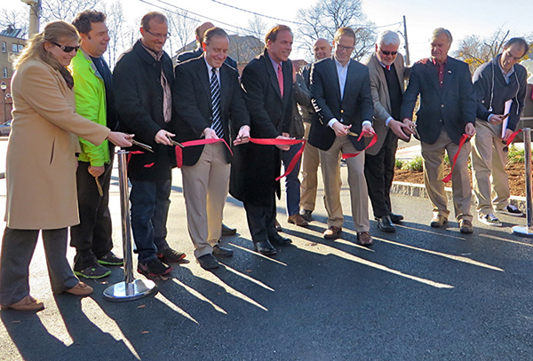
From left to right: Kimberley Sloan, Project Manager, MassDOT; Peter Sutton, MassDOT; Phil Goff, East Arlington Livable Streets Coalition; Paul Stedman, Director, MassDOT Highway Division District 4; State Representative David M. Rogers; Adam Chapdelaine, Town Manager, Arlington; Kevin Greeley, Chair, Arlington Board of Selectmen; State Senator Kenneth Donnelly; Nathaniel Cabral-Curtis, Howard-Stein-Hudson Associates; and (back row) Joe Curro, Arlington Selectman. [Photo: Adam Auster]
Next Story • Previous
Story • Back to Top
The Boston Region MPO has been selected to take part in a yearlong training program for metropolitan regions that are starting to use performance-based planning to make decisions about transportation investments and assess the outcomes of those investments.
The training academy was created by the non-profit organization, Transportation for America, in partnership with the Federal Highway Administration. It will educate teams of local business organizations, civic leaders, and transportation professionals about best practices for transportation performance management.
Performance management is a systematic approach to decision-making. It involves using community input to help set goals for transportation improvements; utilizing objective data to inform investment decisions; and applying performance measures to gauge progress toward goals.
This opportunity will help the Boston Region MPO refine its methods for selecting transportation projects to receive federal funding in the Boston region.
The Boston training team includes representatives from Central Transportation Planning Staff (the staff to the Boston Region MPO), MassDOT, the Metropolitan Area Planning Council, the Massachusetts Bay Transportation Authority Advisory Board, the City of Boston, the Barr Foundation, the 128 Business Council, and A Better City.
Next Story • Previous
Story • Back to Top
In 1965, Cambridge Seven Associates created the first map of the Massachusetts Bay Transportation Authority’s (MBTA) rapid-transit system. That marked the first time that all four MBTA transit lines were displayed on one map in a concise, easy-to-read manner, and in their now-iconic colors representing the Blue, Green, Red, and Orange Lines. As the MBTA system expanded, the map was re-designed several times; each time, the matter of how to depict the Green Line had the greatest effect on the map’s design.
When the original map (Figure 1, below) was created, the Red Line was shorter than it is today, terminating at Harvard Station to the north and Mattapan Station to the south. The northbound Orange Line had a different route, which terminated in Everett. Representing the Mattapan branch on the Red Line and all five surface Green Lines (shown as thin lines) omitted most, if not all, of the station names. Only three of the numerous Green Line stations beyond Kenmore and Symphony were shown, because to portray all of them would overwhelm the map’s layout. In order to get the full picture of the Green Line, the public needed to rely on additional maps posted in transit vehicles and at stations.
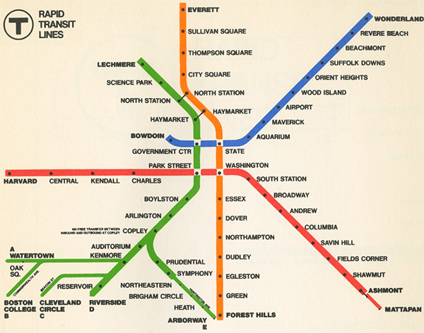
Figure 1: The original MBTA Rapid Transit Map, circa 1965
In the course of one generation, the MBTA system changed greatly. The Red Line was extended to Alewife to the north and Braintree to the south. The northern section of the Orange Line was rerouted from Everett to Oak Grove in Malden, while the southern section was relocated from its elevated tracks over Washington Street in Boston to the Southwest Corridor. In addition, the “A” branch of the Green Line was eliminated.
The expanded system left even less space for illustrating all of the Green Line stations on the map that was developed circa 1990 (Figure 2, below). In this map, four Green Line branches were relegated to an even smaller portion of the map. By continuing to omit Green Line surface stations, the MBTA map kept a balanced design for all-four transit lines and their branches.
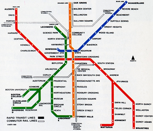
Figure 2: The MBTA Rapid Transit Map, circa 1990
In 1991, an early map design test (Figure 3, below) attempted to give every station on the MBTA system equal weight. Every Green Line stop on each branch of the line was included, which forced a design in which the Green Line appeared to represent more than fifty percent of the overall system. This design test raised an issue that would need to be addressed in future designs of the MBTA map: how to display all of the Green Line stations while keeping illustrations of the Green Line balanced with the other transit lines. Addressing this issue would need to wait, however, as the next design would focus on visualizing geographic reality rather than incorporating all of the Green Line station information.
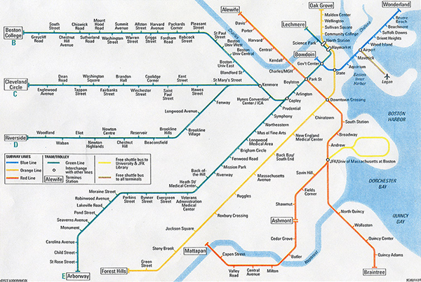
Figure 3: Map design depicting the expanded Green Line, 1991
In 1995, the MBTA Rapid Transit Map was redesigned completely, largely because the Silver Line was added to the system. The Silver Line needed to be placed where the Orange Line had resided on the map, which created a kind of domino effect; the Orange Line needed to be moved to where the Green Line was, and so on. At this time, the MBTA also desired to better represent the Green Line as a whole.
The next map design (Figure 4, below) was more accurate geographically. Drawn in a stylized fashion, the transit lines were shown closer to where they exist in reality. A shoreline was added, giving the map a better sense of place. Although the Green Line branches now were drawn more realistically, the map still lacked room for all the station names. The MBTA compromised by citing every station on the “D” branch and only the accessible stations on the other three branches.
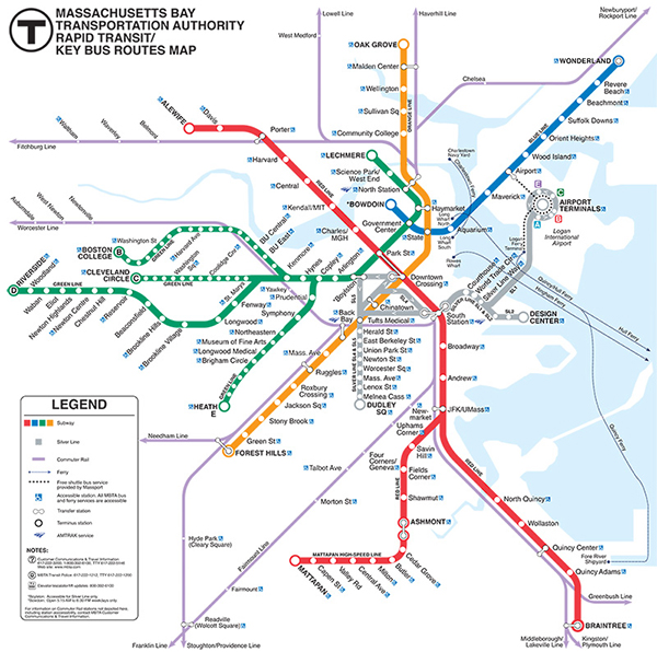
Figure 4: The MBTA Rapid Transit Map, circa 1995
Today’s map of the transit system got its start in the summer of 2013, when the MBTA held a contest asking for the public to submit their own designs and ideas for a new rapid-transit map. After the public chose a winner, and the MBTA reviewed hundreds of public comments, the MBTA discerned that what the public wanted most from the map was equal pictorial weight for the stations. The public wanted every MBTA station shown, and felt that a sense of geographic reality was less important.
Taking all of this into account, the MBTA redesigned the rapid transit map (Figure 5, below) to include every Green Line and Silver Line station. Adding the MBTA’s Key Bus routes left space at a premium on the map. The solution was to give up the sense of geographic reality and revert to earlier designs that represented the map as a schematic.
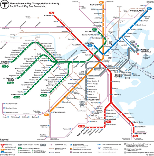
Figure 5: MBTA Rapid Transit Map, circa 2015
Given the space limitations and the desire to keep a balanced look, the four Green Line branches were drawn as curved rather than horizontal lines. Not only did this provide space to label every station, it allowed for horizontal text, which is preferred for readability. The angled lines representing the Green Line branches also allowed the Key Bus routes to intersect in a clear and easy-to-read manner.
Of all the maps that the MBTA has produced over the years, the current map reflects the most amount of public input into its design. After almost 50 years, the public now has an all-inclusive rapid-transit map, where very station is exhibited and labeled.
—Kenneth Dumas is a cartographer at Central Transportation Planning Staff, the staff to the Boston Region MPO. He has been the designer of the MBTA Rapid Transit Map since 1995.
Next Story • Previous
Story • Back to Top
In December 2015, President Obama signed the “Fixing America’s Surface Transportation Act” (FAST Act), which authorizes $305 billion in federal funding over the next five years for improving the nation’s roads, bridges, and rail and transit systems. Massachusetts is expected to receive more than $5 billion during the life of the bill, nearly ten percent more than current funding levels.
The FAST Act maintains many of the priorities seen in former legislation for federal transportation funding programs; it focuses on issues such as improving safety and accelerating project delivery, while creating new funding programs and reforming existing ones to address national priorities.
One of the major highlights of the bill includes restructuring the existing Surface Transportation Program (STP) into a block grant program. The new program is intended to provide more flexibility and enhance state and local control for addressing transportation needs. A wide variety of projects and programs may be eligible for this grant funding, ranging from construction projects for all surface transportation modes, to protective measures for infrastructure exposed to extreme environmental events, to congestion pricing strategies. State decisions regarding use of these grants must be made in consultation with MPOs and there are federal annual reporting requirements associated with them.
Regarding rail and transit, the bill increases funding for buses and bus facilities through formula funding and competitive grants programs, with reforms that allow for more flexibility in vehicle procurement. Funding for safety improvements at highway-railway grade crossings has also increased. Reforms to intercity rail funding include a change in Amtrak’s funding structure that allows the net operating revenues of the Northeast Corridor route to be re-invested in that corridor.
The new bill also emphasizes investing in freight transportation infrastructure, establishing the National Highway Freight Program—a formula-funding program—for investing in projects on the National Highway Freight Network. A provision allows for MPOs, in consultation with states, to designate “critical urban freight corridors” important to the movement of freight in their regions.
A new competitive grant program, Nationally Significant Freight and Highway Projects (NSFHP), will support projects that generate national or regional economic benefits; address significant bottlenecks; improve connectivity in the national or regional freight transportation network; and enhance resiliency of critical highway infrastructure. MPOs are among the eligible grant recipients in this funding category.
Other themes that run through the new bill accentuate using advanced technologies and congestion- management tools (such as vehicle-to-infrastructure communication equipment), and promoting public-private partnerships for investing in the transportation system.
For more about the FAST Act, visit http://transportation.house.gov/fast-act/. We will provide details about how the new legislation will affect the Boston Region MPO’s planning and programming in future editions of TRANSREPORT.
Next Story • Previous
Story • Back to Top