Memorandum
Date: October 17, 2013
To: Boston Region Metropolitan Planning Organization
From: Seth Asante, MPO Staff
Re: Route 30 Arterial Segment Study in Framingham and Natick
Framingham and Natick as one of the priority arterial segments in need of maintenance, modernization, safety, and mobility improvements. The arterial segment of Route 30 from Ring Road in Framingham to the TJX Companies driveway in Natick was selected for study because MassDOT and the Towns of Framingham and Natick cited serious mobility and safety issues for pedestrians, bicycles, and motorists in the segment, as well as congestion. An advisory task force composed of representatives from MassDOT and the Towns of Framingham and Natick was established to participate in this study. MPO staff met with the task force two times: once to discuss the work scope and finalize the existing conditions and problems, and another time to present improvement recommendations for comments. The purposes of this study were to inventory existing problems in the arterial segment under study and develop transportation improvements to address those problems.
This memorandum is organized into seven sections: 1) executive summary, 2) background, 3) data collection, 4) existing conditions analyses, 5) future traffic growth, 6) recommended improvements, and 7) conclusions and next steps. Several types of data were collected in the field or obtained from other sources and used to evaluate the existing conditions—including data and information on operations, safety, mobility, and land use. The MassDOT Highway and Planning Division, Town of Framingham and Town of Natick provided most of the data used in this study.
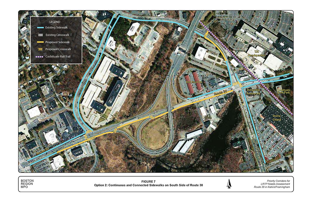
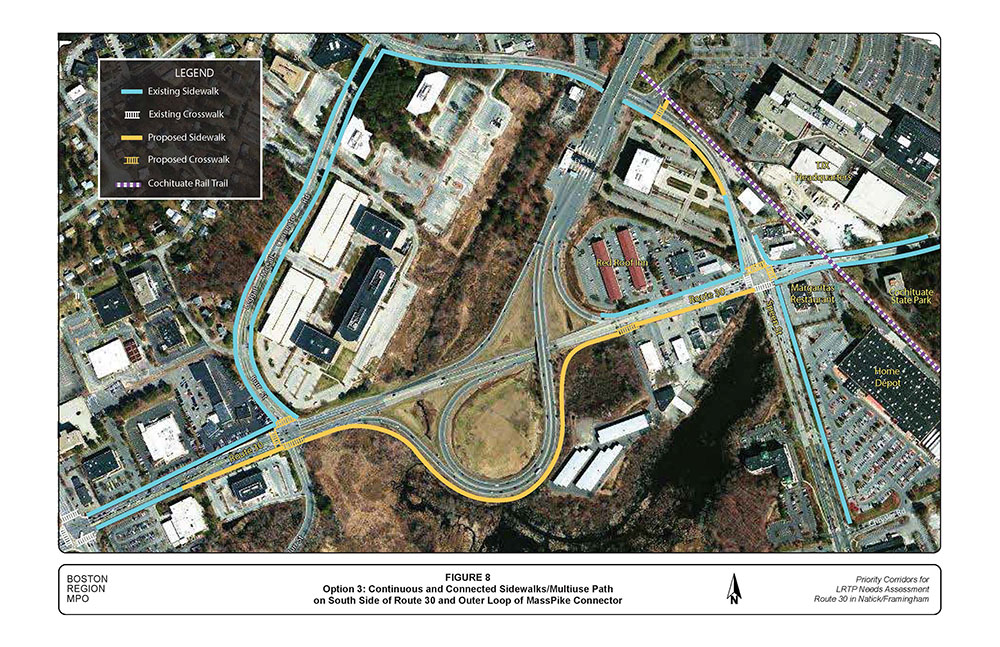
Because of the serious mobility and safety issues facing pedestrians and bicyclists in the arterial segment, MPO staff developed three options for addressing gaps in sidewalks on Route 30 in the vicinity of the MassPike, and for providing shared-use paths for bicyclists. Cost and effectiveness (i.e., safety for pedestrians and bicyclists) are the two primary factors for selecting a preferred alternative. The three options are:
In addition, MPO staff suggests the following improvements to accommodate pedestrians and bicyclists.
Analysis and field observations identified three traffic signals that were operating unsatisfactorily during the peak periods. MPO staff recommends adjusting the existing traffic signal timings at the following intersections to improve traffic flow:
The segment of Route 30 with the two-way center left-turn lane had a large number of angle-type crashes involving motorists turning into or out of driveways (primary contributing factors attributed to failure to yield right-of-way and changing lanes). MPO staff recommends the following safety improvements:
Currently, the Route 30 and Speen Street intersection is operating at capacity during peak periods, and analysis shows that significant improvement in capacity resulting from traffic signal retiming is not anticipated. Peak period traffic demands at the intersection are so great that a traffic queue is created on each approach. In addition, wetlands and businesses adjacent to the intersection place constraints on further widening the space. An evaluation of traffic flow patterns indicated that on average about 70 percent of the traffic heading westbound on Route 30 just west of the Speen Street intersection proceeds to the MassPike. Based on this observation, MPO staff assumed that the majority of the high-volume northbound left-turn, southbound right-turn, and, to a lesser degree, westbound straight-through movements at the Speen Street intersection are destined to the MassPike.
For a medium-term improvement at this location, MPO staff tested adding a traffic lane in the westbound direction of Route 30. The lane would start at the TJX driveway, cross Speen Street, and continue as a third lane between Speen Street and the I-90 on ramp, which would become a two-lane ramp.
Comparison of intersection delays and queues with and without the third lane showed a reduction in delay per vehicle of up to 25% and queue lengths of up to 40%. These estimates vary by traffic movement, approach, traffic signal design parameters, and peak hour.
Potential affects from adding a third westbound lane would be land takings, and reduced safety at access/egress points at business driveways along the Route 30 segment, where the widening would occur. To make this improvement work successfully, MPO staff recommends that the two-way left-turn lane in this segment be replaced with a raised median, and access/egress points to business driveways be restricted to right-turn-in and right-turn-out to improve safety.
For long-term improvements, MPO staff developed five concepts for discussion, and the future consideration of Natick, Framingham, and MassDOT. These conceptual designs exhibit potential advantages and disadvantages regarding driveway access/egress, constructability, cost, environmental impacts, traffic operations, and other considerations. The five concepts are:
Cost and effectiveness (i.e., trail user safety) are the two primary factors for selecting the preferred option.
The study of the Route 30 segment between the TJX driveway and the intersection at Ring Road/Shopper’s World Way examined existing conditions and identified short- and long-term improvement concepts.
The main concerns in this segment relate to connections to the MassPike; peak hour delays and queues, especially at the Route 30/Speen Street intersection during the PM peak period; incomplete network for bicyclist and pedestrian circulation, including the crossing of the Cochituate Rail Trail at Route 30, east of Speen Street; and congestion and safety related to driveway access, including the TJX driveway.
The study identified three options for closing the gaps in the existing bicycle and pedestrian circulation, including recommendations for signs and markings; traffic signal retiming schemes at four signalized intersections; traffic management options for the Route 30 segment between Speen Street and the MassPike on ramp; and, six medium- and long-term concepts for reconfiguring the connection of Speen Street and Route 30 to the MassPike, including adding a westbound traffic lane to Route 30 from the TJX driveway to the I-90 connector.
Long-term improvements in the Route 30 study segment hinge on improved regional connections between the MassPike and the local network that serves Framingham and Natick, and other municipalities. Examining the design and feasibility of various connection options of Route 30 and Speen Street to the MassPike is particularly timely. MassDOT is planning to remove the toll plazas throughout the MassPike and replace them with an automatic toll collection system, All Electronic Tolling (AET). Connection options to I-90 from Framingham and Natick should be designed to include the parameters and assumptions built into MassDOT’s AET project.
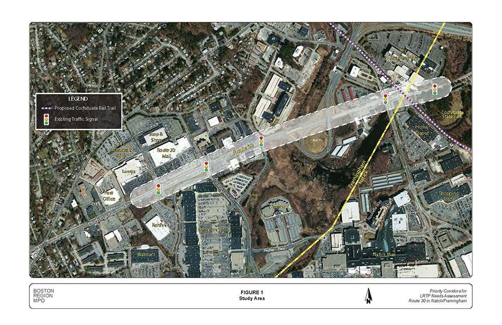
The arterial segment of Route 30 between Ring Road in Framingham and the TJX Companies driveway in Natick (Figure 1) was selected for study because the Boston Region MPO’s Long-Range Transportation Plan identified Route 30 as one of the priority arterial segments in need of maintenance, modernization, safety and mobility improvements, transit-service enhancements, and modernization. Moreover, MassDOT’s Highway Division District 3 cites serious mobility and safety issues for pedestrians, bicycles, and motorists in the segment. To help identify solutions for addressing problems in priority arterial segments, an arterial segment study was included in the federal fiscal year (FFY) 2013 Unified Planning Work Program (UPWP).2
An arterial segment study is usually a logical way to multimodal transportation needs in a corridor. Typically, an arterial segment study uses a holistic approach. It analyzes services, and makes associated recommendations within the roadway’s right-of-way, taking into account the needs of all abutters and users—pedestrians, bicyclists, motorists, public-transportation users, and the like. Implementing the recommendations in this report would result in an improved roadway corridor; one where it is safe to cross the street; walk or cycle to shops and recreational areas; and one that is safer for motorists.
The purposes of this study were to inventory existing problems in the arterial segment under study and develop multimodal transportation improvements to address those problems. MPO staff worked closely with an advisory task force composed of representatives from MassDOT and the Towns of Framingham and Natick. MPO staff met with the task force twice: once to discuss the work scope and finalize the existing conditions and problems, and another time to present the improvement recommendations for comments.

This memorandum is organized into seven sections: an executive summary and six sections. Section 2 gives a brief background of the study. Section 3 describes the data collection methods and sources while Section 4 presents the existing conditions analyses. Section 5 presents future traffic growth while Section 6 describes the future conditions and improvements. Section 7 is presents the study conclusions and next steps.
Several types of data were collected in the field or obtained from other sources and were used to evaluate the existing conditions—they include data and information on operations, safety, mobility, and land use.
The MassDOT Highway Division’s Traffic Data Collection collected turning-movement counts (TMCs) at the study intersections in November 2012, when schools were in session. The counts were conducted during weekday morning and evening peak travel periods. Heavy vehicles (with six or more tires), including school buses, transit buses, and trucks, were counted separately. Pedestrian and bicycle counts were conducted simultaneously with the TMCs. In addition, MassDOT Highway Division’s Traffic Data Collection conducted automatic traffic recorder (ATR)3 counts for the MassPike on- and off-ramps (see Appendix A).
The town of Framingham provided existing signal timings, as-built traffic signal plans, and phase sequences of the study intersections. The signal timing plan and phase sequence for the intersection of Route 30 and the TJX Companies driveway were measured in the field. A field inventory of intersection geometrics, lane configurations, and pedestrian and bicyclists amenities were conducted for this study. (Traffic signal timing information and intersection geometrics are located in Appendix B.)
MPO staff used crash data—from January 2008 through December 2012—obtained from the Framingham Police Department and the Natick Police Department, along with data from MassDOT’s Registry of Motor Vehicles.
The towns of Framingham and Natick provided information on land use, proposed developments, mitigation actions, and improvements.
The arterial segment of Route 30 under study is functionally classified as a principal arterial roadway. It is town owned and generally runs in an east-west direction (Figure 1). In Framingham, Route 30 is called Cochituate Road and it has two 11-foot travel lanes in each direction, with wider exclusive turn lanes at the signalized intersections. The segment just west of Speen Street has a 300-foot long two-way, left-turn lane. In Natick, Route 30 is called Commonwealth Road and it has an 11-foot travel lane in each direction with wider turn lanes at its intersection with TJX Companies driveway. There is no shoulder or bicycle lane in the study segment. The posted speed limit is generally 40 miles per hour (mph) in the Framingham segment and 35 mph in the Natick segment. There are sidewalks on both sides of Route 30 for most part of the segment under study; however, major gaps exist in sidewalks in the vicinity of the MassPike. There are five signalized intersections in the segment; four of which are under the jurisdiction of Framingham, and one located at the TJX Companies driveway, which is under the jurisdiction of Natick.
4.2 Intersections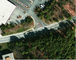 Route 30 intersects the TJX Companies driveway to form a T-intersection. At the intersection, Route 30 provides one through travel lane in each direction, an exclusive left-turn lane on the eastbound approach, and an exclusive right-turn lane on the westbound approach. The TJX Companies driveway has exclusive right-turn and left-turn lanes. The intersection curb radii are adequate for truck traffic. Although the intersection has a fully actuated traffic signal with pedestrian signals and pushbuttons, a police detail conducts traffic at the intersection during the PM peak hour to assist employees exiting from the driveway onto Route 30 because of a recurrent traffic queue that blocks the intersection. In addition, there are documented concerns expressed by TJX that its business lacks good access to Route 30 and I-90 because of congestion through Speen Street and beyond. There is a crosswalk on the west leg of the intersection. The land use in the vicinity of the intersection is commercial and recreational—with Cochituate State Park located on the south side of Route 30.
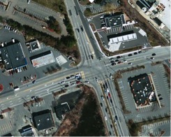 Route 30 intersects Speen Street to form a four-leg signalized intersection. The eastbound Route 30 approach has four lanes (exclusive left-turn lane, through lane, shared through/right-turn lane, and exclusive right-turn lane), while the westbound approach has three lanes (exclusive left-turn lane, through lane, shared through/right-turn lane). The Speen Street southbound approach has four lanes (exclusive left-turn lane, two through lanes, and exclusive right-turn lane), while the northbound approach consists of four lanes (exclusive double left-turn lanes, through lane, and shared through/right-turn lane). The intersection curb radii are adequate for truck traffic. The intersection has a fully actuated traffic signal with pedestrian signals and pushbuttons and an emergency preemption system; but it is not coordinated with other Route 30 or Speen Street intersections because the MassPike traffic disrupts platoon progression on Route 30. There are no sidewalks on Route 30 or Speen Street in the southwest quadrant of the intersection and the east and north legs of the intersection lack crosswalks. The land use in the vicinity is commercial.
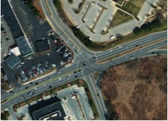 Route 30 intersects Burr Street to form a four-leg intersection. The Route 30 eastbound approach consists of three travel lanes (exclusive left-turn lane, through lane, and shared through/right-turn lane). The westbound approach has three lanes (two through lanes and an exclusive right-turn lane). The Burr
Street southbound approach consists of two lanes (exclusive left turn lane and shared left/through/right lane), while the northbound approach consists of two lanes (shared left/through lane and channelized right turn lane). The intersection curb radii are adequate for truck traffic. The intersection has a fully actuated and coordinated traffic signal with an emergency vehicle preemption system. The sidewalks on Route 30 terminate at the intersection, which lacks crosswalk and pedestrian signals. The land use in the vicinity is commercial.
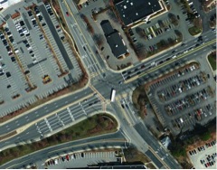 Route 30 intersects Whittier Street/Shopper’s World Drive to form a four-leg intersection. The eastbound approach of Route 30 has five lanes (exclusive left turn lane, two through lanes, and exclusive double right-turn lanes), while the westbound approach has three lanes (exclusive left-turn lane, through lane, and shared through/right-turn lane). The intersection curb radii are adequate for truck traffic. The Whittier Street southbound approach consists of four lanes (exclusive left turn lane, shared left/through lane, through lane, and exclusive right-turn lane). The Shopper’s World Drive northbound approach consists of three lanes (shared left/through lane, through lane, and exclusive right-turn lane). The intersection has a fully actuated traffic signal with coordination, an emergency vehicle preemption system, and pedestrian signals with pushbuttons. There are crosswalks on all except for the east leg. The land use in the vicinity is commercial.
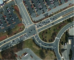 Route 30 intersects Ring Road and Shopper’s World Way to form a four-leg intersection. Each approach of Route 30 has an exclusive left-turn lane, two through lanes, and an exclusive right-turn lane. The Ring Road northbound approach consists of a three lanes (double left-turn lanes and a shared through/right- turn lane), while the Shopper’s World Way southbound approach has three lanes (exclusive left-turn lane, shared left/through lane, and exclusive right-turn lane). The intersection curb radii are adequate for truck traffic. The intersection has a fully actuated traffic signal with coordination, emergency vehicle preemption system, and pedestrian signals with pushbuttons. The intersection has crosswalks on all except for the west leg. The land use in the vicinity is commercial.
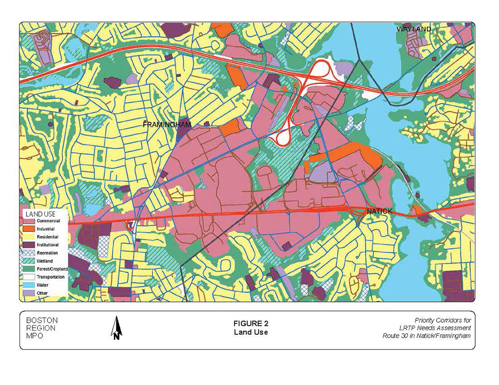
The seen in the land use map (Figure 2) the area surrounding the roadway segment under study is zoned for both commercial and industrial use in Framingham and Natick. The area, known as the Golden Triangle, is a desirable shopping and industrial site. It is designated as a high-priority business development area, and has direct access to the MassPike, Route 9, and Route 30.
Based on discussions with representatives from Framingham and Natick, the following developments are proposed or expected in the area:
There are sidewalks on Route 30 in the Framingham and Natick segments; however, they are not continuous or connected. Gaps exist in the sidewalk network in the vicinity of the MassPike and Route 30 ramp junctions. In the Framingham section, the sidewalk on the north side of Route 30 terminates at Burr Street and picks up at the Red Roof Inn near the Speen Street intersection. Similarly, the sidewalk on the south side of Route 30 terminates just east of the FedEx driveway and picks up at the Margaritas restaurant on the southeast corner of the Speen Street intersection. Figure 3 shows the existing sidewalks and gaps near the MassPike-Route 30 ramp junctions.
In the segment under study, pedestrian crossings are permitted only at signalized intersections and crosswalks that are accessible with Americans with Disabilities Act compliant ramps; and pedestrian signals with pushbuttons have been provided at those intersections. The closely spaced intersections make midblock crossing unnecessary. Table 1 presents the number of pedestrians and bicyclists observed at the study intersections during AM and PM peak travel periods when the TMC and ATR counts were conducted. The low pedestrian and bicyclist volumes might have resulted from the colder weather and shorter daylight in November and the high volume of traffic during peak periods. In addition, the low numbers might have been a result of the lack of amenities that intend to provide safety and comfort for bicyclists, such as:
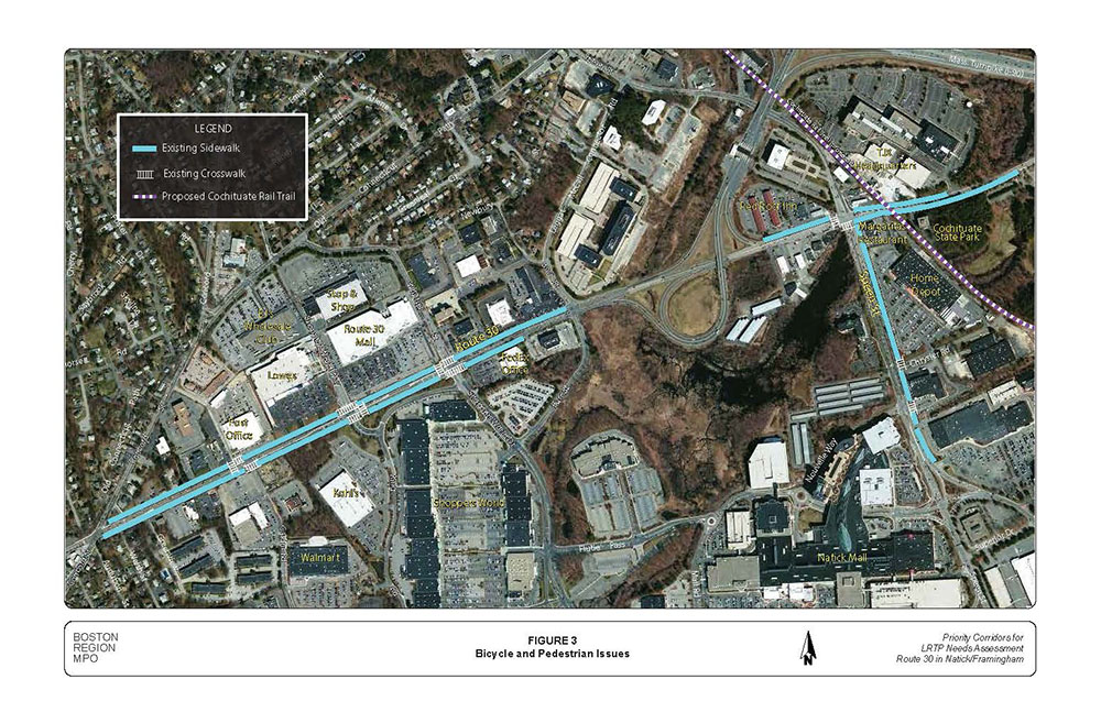
TABLE 1
Pedestrian and Bicycle Counts at the Study Intersections
|
Pedestrian Count: AM Peak Period |
Pedestrian Count: PM Peak Period |
Bicyclist Count: AM Peak Period |
Bicyclist Count: PM Peak Period |
Route 30 at TJX Co. Driveway |
0 |
0 |
0 |
0 |
Route 30 at Speen Street |
4 |
4 |
0 |
0 |
Route 30 at Burr Street |
1 |
1 |
0 |
1 |
Route 30 at Whittier Street |
5 |
4 |
0 |
0 |
Route 30 at Ring Road |
6 |
13 |
0 |
1 |
Note: The AM peak period is 7:00 AM to 9:00 AM, and the PM peak period is 4:00 PM to 6:00 PM.
Source: Central Transportation Planning Staff.
There are five Metro West Regional Transit Authority (MWRTA) bus services operating within the study area:
Routes 2 and 3 connect South Framingham to Shopper’s World and the Natick Mall along a long circuit route; with Route 2 traveling clockwise around the circuit and Route 3 operating counter clockwise. Routes 2 and 3 cross Cochituate Road at Whittier Street and Shopper’s World Drive and briefly run along Cochituate Road from Concord Street to Shopper’s World. Both routes circulate through Shopper’s World and the Natick Mall.
Routes 10, 11, and the Natick Commuter Shuttle operate along Cochituate Road from North Main Street (Route 27) to Speen Street. Routes 10 and 11 connect downtown Natick to the Natick Mall along a circuit route; with Route 10 operating counter clockwise around the loop and Route 11 operating clockwise. The Natick Commuter Bus operates to and from MBTA commuter rail stations in Natick to several major employers in Natick, including MathWorks.
Routes 2, 3, and 10 operate Monday to Saturday, while Route 11 and the Natick Commuter Shuttle operate Monday to Friday only. Routes 2 and 3 operate every 60 to 75 minutes from 6:30 AM to 7:55 PM weekdays and 9:30 AM to 5:30 PM Saturday. Routes 10 and 11 operate every 85 minutes from 6:30 AM to 8:11 PM weekdays. Route 10 also operates on Saturday from 9:30 AM to 5:30 PM. The Natick Commuter Shuttle operates several trips in the AM and PM peak periods.
The MWRTA offers a flag stop where buses stop only on an as-needed or as-requested basis. The average daily ridership from the stop at Macy’s at the Natick Mall is 45 riders; the stop at the shelter at Shoppers World has an average of 15 boardings per day. MWRTA has adjusted schedules since 2008 to account for longer travel times in the peak periods. The 2008 weekday data collected on MWRTA routes by MPO staff showed 160 passengers on Route 2; 206 passengers on Route 3; 117 passengers on Route 10; 43 passengers on Route 11; and 69 passengers on the Natick Commuter Shuttle. MWRTA ridership has increased since 2008, but new data by route is not yet available.
The CRT is a proposed multi-use trail that would extend from the Village of Saxonville in Framingham to Natick Center, a distance of four miles. At the time this writing, the Framingham section of the trail is paved, but not opened to the public, although it is being used now. The Natick section of the trail is in the planning stage. Because of its close proximity to office buildings, shopping centers, and residential areas, the trail is expected to provide residents with an attractive alternative to driving. In addition, a planned connection to the commuter rail station in Natick Center will open the door for even greater transportation use. The Framingham section will terminate at Route 30 near Home Depot and Cochituate State Park. The Natick section will start at the point where the Framingham section ends, and will terminate at the commuter rail station in Natick Center. The Natick section also will have a spur connecting the Cochituate Rail Trail to the Natick Mall.
The relationship between this study and the Cochituate Rail Trail is the crossing of the trail at Route 30 and what impact that would have on the study area. The trail crossing is complicated by the following site conditions:
The primary concern of Framingham and Natick is the increased exposure and risk for trail users because of the conditions listed above, as well as the effect the trail might have by crossing over traffic operations in the vicinity. One of the objectives of this study was to evaluate the alternatives for trail users to cross Route 30 safely while considering what the delay consequences for both trail users and motorists would be.
MPO staff used crash data obtained from the Framingham and Natick Police Departments and from the MassDOT Registry of Motor Vehicles to evaluate safety for motorists, pedestrians, and bicyclists. The crash data cover the period from January 2007 through December 2012. The details of the crashes in terms of severity, manner of collision, and ambient light conditions at each of the study intersections are presented in Table 2. The crash rates for the study intersections presented at the bottom of Table 2 were calculated per MassDOT methodology. The MassDOT Highway Division’s District 3 average crash rate (published by MassDOT based on crash information queried on January 23, 2013) is 0.89 crashes per million entering vehicles for signalized intersections. The crash rate worksheets and collision diagrams are located din Appendix C. Using the District 3 crash rate data as a threshold, none of the study intersections was identified as a high-crash location.
Although the Route 30 and Speen Street intersection had 85 crashes within the six-year period, it did not meet the District 3 threshold because of the high ADT volumes at the intersection. The most prevalent crash types were angle and rear-end collisions because of running red lights, failure to yield right-of-way, and following too close, inattention, and inability to stop in reaction to a traffic queue.
In addition, between 24 and 30 percent of the crashes occurred during peak travel periods—when there are congestion and traffic queues. In addition, the segment of Route 30 west of Speen Street, with the two-way center left-turn lane (TWLTL) had 22 crashes.
TABLE 2
Crash Summaries and Rates for Study Intersections
|
Route 30 at Speen Street |
Route 30 at Burr Street |
Route 30 at Whittier Street |
Route 30 at Ring Road |
Route 30 at TJX Driveway |
Fatal Injury |
0 |
0 |
0 |
0 |
0 |
Non-fatal injury |
22 |
17 |
20 |
0 |
6 |
Property damage only |
58 |
30 |
40 |
21 |
6 |
Unknown/not reported |
5 |
0 |
3 |
0 |
1 |
Angle |
32 |
12 |
17 |
7 |
5 |
Rear-end |
34 |
24 |
27 |
6 |
4 |
Sideswipe |
11 |
6 |
11 |
5 |
0 |
Single-vehicle crash |
1 |
3 |
5 |
0 |
4 |
Head-on |
2 |
1 |
0 |
1 |
0 |
Unknown/not reported |
5 |
1 |
3 |
1 |
0 |
Pedestrians |
0 |
0 |
0 |
0 |
0 |
Bicyclists |
1 |
1 |
0 |
0 |
0 |
AM or PM peak period* |
29 |
14 |
15 |
6 |
1 |
Non-peak period |
56 |
33 |
48 |
15 |
12 |
Dry |
51 |
35 |
49 |
13 |
12 |
Wet or icy |
16 |
12 |
14 |
8 |
1 |
Daylight |
69 |
38 |
47 |
18 |
10 |
Dark (lit or unlit) |
16 |
9 |
16 |
3 |
3 |
Total crashes |
85 |
47 |
63 |
21 |
13 |
Six-year average |
14 |
8 |
11 |
4 |
2 |
Crash rate |
0.7 |
0.51 |
0.76 |
0.34 |
0.37 |
District 3 average crash rate |
0.89 |
0.89 |
0.89 |
0.89 |
0.89 |
* The AM peak period is 7:00 AM to 9:00 AM, and the PM peak period is 4:00 PM to 6:00 PM.
Source: Central Transportation Planning Staff.
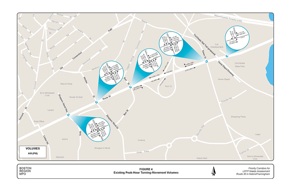
The average weekday traffic volumes on Route 30 ranged between 22,000 and 40,000 vehicles per day. The highest ADT occurred in the segment between Speen Street and the MassPike and the lowest ADT occurred in the segment between the TJX Companies driveway and the Speen Street intersection. The percentage of trucks in the study-area intersections during the AM and PM peak periods ranged between 1.0% and 2.8% (Table 3). These truck rates are not considered particularly high for peak-period traffic conditions. Also, staff did not detect any roadway geometry—such as turning radii, which would inhibit truck traffic flow—other than the extreme traffic congestion that exists in this area during peak hours and affects all traffic. The peak-hour turning movement volumes for the study intersections and the MassPike ramps are presented in Figure 4.
Using the data and information collected, MPO staff built a traffic analysis network for the AM and PM peak periods (with Synchro Studio4) to assess the capacity and quality of traffic flow in the arterial segment under study.
TABLE 3
Percentage of Heavy Vehicles at Study Intersections during Peak Periods*
Intersection/Approach |
Percent of Heavy Vehicles |
Route 30 at TJX Companies Driveway: |
-- |
Route 30 Eastbound |
1.2% |
Route 30 Westbound |
1.0 |
TJX Driveway Southbound |
0.0 |
Route 30 at Speen Street: |
-- |
Route 30 Eastbound |
2.0% |
Route 30 Westbound |
2.1 |
Speen Street Northbound |
2.2 |
Speen Street Southbound |
1.6 |
Route 30 Burr Street: |
-- |
Route 30 Eastbound |
2.0% |
Route 30 Westbound |
2.0 |
Burr Street Northbound |
1.4 |
Burr Street Southbound |
0.7 |
Route 30 at Whittier Street: |
-- |
Route 30 Eastbound |
2.4% |
Route 30 Westbound |
2.5 |
Whittier Street Northbound |
1.0 |
Whittier Street Southbound |
0.9 |
Route 30 at Shopper’s World Way/Ring Road: |
-- |
Route 30 Eastbound |
2.8% |
Route 30 Westbound |
1.8 |
Shopper’s World Way Southbound |
2.4 |
Ring Road Northbound |
2.4 |
* The AM peak period is 7:00 AM to 9:00 AM, and the PM peak period is 4:00 PM to 6:00 PM.
Source: Central Transportation Planning Staff.
The analyses were conducted in a manner consistent with the Highway Capacity Manual (HCM) methodologies (included in Appendix D). The HCM methodology demonstrates the driving conditions at signalized intersections it in terms of LOS ratings from A through F. LOS A represents the best operating conditions (little to no delay), while LOS F represents the worst operating conditions (very long delay). LOS E represents operating conditions at capacity (limit of acceptable delay). The control delays associated with each level of service for signalized intersections are presented in Table 4.
TABLE 4
Levels of Service and Control Delays at Signalized Intersection
|
Control Delay |
A |
≤ 10 |
B |
> 10-20 |
C |
> 20-35 |
D |
> 35-55 |
E |
> 55-80 |
F |
> 80 |
Source: Central Transportation Planning Staff.
Table 5 presents the peak-hour performance measures for the existing conditions, summarized below:
TABLE 5
Peak-Hour Level of Service, Delay, and Queue: Existing versus Retimed Traffic Signals
|
|
|
AM Existing LOS |
AM Existing Delaya |
AM Existing Queueb |
AM Retimed LOS |
AM Retimed Queue |
AM Retimed Queue |
PM Existing LOS |
PM Existing Delay |
PM Existing Queue |
PM Retimed LOS |
PM Retimed Delay |
PM Retimed Queue |
|---|---|---|---|---|---|---|---|---|---|---|---|---|---|
| Intersection/ Approach |
Move-ment |
||||||||||||
Route 30 at TJX Driveway: |
-- |
-- |
-- |
-- |
-- |
-- |
-- |
-- |
-- |
-- |
-- |
-- |
--- |
Route 30 Eastbound |
L |
C |
27 |
#587 |
C |
22 |
#574 |
B |
10 |
20 |
B |
10 |
20 |
Route 30 Eastbound |
T |
A |
6 |
450 |
A |
5 |
450 |
A |
6 |
#335 |
A |
6 |
335 |
Route 30 Westbound |
T |
C |
37 |
#550 |
C |
33 |
#550 |
E |
55 |
#559 |
E |
55 |
#559 |
Route 30 Westbound |
R |
B |
20 |
51 |
A |
19 |
51 |
B |
14 |
12 |
B |
14 |
12 |
TJX Driveway |
L |
D |
44 |
25 |
D |
42 |
25 |
D |
39 |
#122 |
C |
39 |
#122 |
TJX Driveway |
R |
B |
14 |
15 |
A |
13 |
15 |
D |
40 |
#540 |
D |
40 |
#540 |
Intersection Total |
All |
C |
21 |
-- |
B |
18 |
-- |
C |
32 |
-- |
C |
32 |
-- |
Route 30 at Speen Street: |
-- |
-- |
-- |
-- |
-- |
-- |
--- |
-- |
-- |
-- |
--- |
-- |
-- |
Route 30 Eastbound |
L |
E |
77 |
#410 |
E |
71 |
#414 |
E |
66 |
155 |
E |
68 |
#170 |
Route 30 Eastbound |
T+R |
E |
62 |
#859 |
E |
76 |
#801 |
F |
87 |
#541 |
E |
60 |
#415 |
Route 30 Eastbound |
R |
C |
22 |
513 |
C |
27 |
#818 |
F |
85 |
#1159 |
E |
62 |
#979 |
Route 30 Westbound |
L |
F |
84 |
#315 |
E |
73 |
#289 |
E |
76 |
#529 |
F |
84 |
#541 |
Route 30 Westbound |
T+R |
D |
43 |
264 |
D |
44 |
255 |
D |
51 |
#535 |
D |
42 |
468 |
Speen St. Northbound |
L |
E |
60 |
#434 |
E |
55 |
#414 |
F |
131 |
#715 |
F |
115 |
#620 |
Speen St. Northbound |
T+R |
F |
120 |
#715 |
F |
80 |
#625 |
D |
42 |
341 |
D |
42 |
316 |
Speen St. Southbound |
L |
E |
71 |
#193 |
E |
75 |
#223 |
E |
76 |
#190 |
E |
64 |
158 |
Speen St. Southbound |
T |
F |
97 |
#324 |
E |
71 |
#296 |
E |
65 |
#450 |
F |
97 |
#465 |
Speen St. Southbound |
R |
D |
36 |
43 |
C |
32 |
40 |
E |
59 |
#449 |
E |
70 |
#444 |
Intersection Total |
All |
E |
67 |
-- |
E |
60 |
-- |
E |
76 |
--- |
E |
70 |
-- |
Route 30 at Burr Street: |
-- |
-- |
-- |
-- |
-- |
--- |
-- |
-- |
--- |
--- |
-- |
-- |
--- |
Route 30 Eastbound |
L |
E |
57 |
m176 |
D |
45 |
m126 |
D |
45 |
m72 |
D |
50 |
m79 |
Route 30 Eastbound |
T+R |
A |
5 |
124 |
A |
10 |
124 |
A |
8 |
m15 |
C |
28 |
m450 |
Route 30 Westbound |
T |
B |
15 |
250 |
B |
16 |
257 |
C |
27 |
582 |
D |
43 |
#706 |
Route 30 Westbound |
R |
E |
56 |
#676 |
E |
59 |
#675 |
B |
16 |
73 |
C |
20 |
87 |
Burr St. Northbound |
L+T |
E |
65 |
#105 |
D |
49 |
93 |
F |
97 |
#130 |
D |
54 |
101 |
Burr St. Northbound |
R |
A |
1 |
0 |
A |
1 |
0 |
A |
1 |
0 |
A |
1 |
0 |
Burr St. Southbound |
L |
D |
39 |
75 |
D |
38 |
68 |
E |
148 |
#492 |
D |
50 |
#402 |
Burr St. Southbound |
L+T+R |
D |
37 |
62 |
D |
38 |
69 |
F |
143 |
#478 |
D |
49 |
#385 |
Intersection Total |
All |
C |
29 |
-- |
C |
30 |
-- |
D |
37 |
-- |
D |
35 |
-- |
Route 30 at Whittier Street: |
--- |
-- |
-- |
-- |
-- |
-- |
-- |
-- |
-- |
-- |
-- |
-- |
-- |
Route 30 Eastbound |
L |
D |
41 |
#94 |
D |
54 |
#65 |
E |
66 |
m88 |
E |
71 |
m#80 |
Route 30 Eastbound |
T |
C |
35 |
#370 |
C |
30 |
#479 |
C |
30 |
m#182 |
D |
51 |
m302 |
Route 30 Eastbound |
R |
B |
18 |
0 |
B |
18 |
0 |
C |
34 |
m16 |
C |
34 |
m13 |
Route 30 Westbound |
L |
D |
42 |
#240 |
D |
45 |
#240 |
C |
26 |
m#525 |
E |
55 |
m#460 |
Route 30 Westbound |
T+R |
A |
10 |
#547 |
B |
11 |
#547 |
B |
19 |
m#725 |
B |
13 |
m#656 |
Shopper’s World Dr. |
L+T |
D |
36 |
54 |
D |
36 |
54 |
F |
> 180 |
#259 |
F |
101 |
#234 |
Shopper’s World Dr. |
R |
C |
22 |
0 |
C |
22 |
0 |
C |
24 |
9 |
C |
22 |
84 |
Whittier St. Southbound |
L |
D |
44 |
#131 |
D |
44 |
#131 |
F |
> 180 |
#375 |
E |
64 |
#336 |
Whittier St. Southbound |
L+T |
D |
39 |
#96 |
D |
40 |
#96 |
F |
> 180 |
#353 |
E |
72 |
#282 |
Whittier St. Southbound |
R |
C |
28 |
0 |
C |
28 |
0 |
D |
38 |
14 |
C |
34 |
15 |
Intersection Total |
All |
C |
26 |
-- |
C |
26 |
-- |
F |
81 |
-- |
D |
47 |
-- |
Route 30 at Ring Road: |
-- |
-- |
-- |
--- |
--- |
-- |
--- |
-- |
-- |
--- |
-- |
-- |
-- |
Route 30 Eastbound |
L |
C |
33 |
m#171 |
D |
47 |
m#172 |
E |
64 |
#303 |
C |
33 |
#274 |
Route 30 Eastbound |
T |
B |
11 |
#480 |
A |
10 |
#446 |
B |
26 |
312 |
B |
16 |
307 |
Route 30 Eastbound |
R |
B |
11 |
m17 |
B |
11 |
m4 |
D |
51 |
91 |
C |
25 |
87 |
Route 30 Westbound |
L |
D |
38 |
m26 |
C |
28 |
m26 |
E |
59 |
m74 |
D |
37 |
m68 |
Route 30 Westbound |
T |
D |
41 |
#435 |
C |
33 |
#442 |
D |
39 |
m436 |
D |
52 |
m#463 |
Route 30 Westbound |
R |
B |
15 |
m67 |
B |
13 |
m67 |
C |
28 |
m80 |
F |
86 |
m95 |
Shopper’s World Way |
L |
D |
36 |
23 |
D |
36 |
23 |
E |
77 |
#132 |
D |
51 |
#121 |
Shopper’s World Way |
T+R |
D |
38 |
52 |
D |
38 |
52 |
F |
>180 |
#284 |
F |
131 |
#288 |
Ring Road Southbound |
L |
D |
37 |
41 |
D |
38 |
41 |
E |
77 |
#148 |
E |
60 |
#125 |
Ring Road Southbound |
L+T |
D |
37 |
42 |
D |
38 |
42 |
E |
77 |
#154 |
E |
60 |
#129 |
Ring Road Southbound |
R |
D |
36 |
0 |
D |
36 |
0 |
D |
49 |
24 |
C |
31 |
31 |
Intersection Total |
All |
C |
29 |
-- |
C |
24 |
-- |
E |
56 |
-- |
D |
46 |
-- |
a Delay in seconds per vehicle. b 95th percentile queue length in feet.
LOS = Level of service. m = Volume for the 95th percentile queue is metered by an upstream signal. .# = The 95th percentile volume exceeds capacity.
Source: Central Transportation Planning Staff.
The following are previous and proposed mitigation improvements; not all of these improvements are in the study area but are listed here because they affect flow into and out of the study area.
To systematically forecast future traffic volumes resulting from changes in a transportation network or land use, a planning model is used. For this study, staff used the Boston Region MPO’s most-recently adopted regional travel demand model set, with socioeconomic components based on forecasts produced by the Metropolitan Area Planning Council. The model is calibrated at a regional level for 164 cities and towns, which include all of the 101 cities and towns in the MPO region. The primary tool used in model calibration is the transportation planning model set implemented in EMME software.5 Total average traffic growth in the study area is projected to be approximately 3.0 percent by 2020; this factor was used to expand existing peak-hour turning-movement volumes into 2020 future turning-movement volumes (Figure 5).
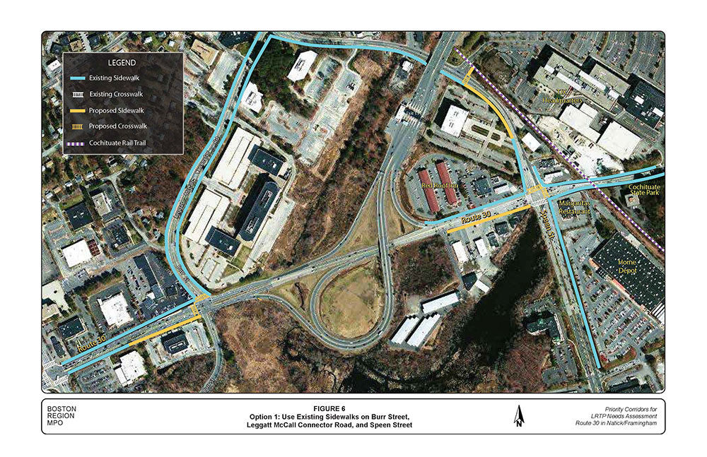
Three options were proposed to address gaps in sidewalks on Route 30 in the vicinity of the MassPike:
Cost and effectiveness are the two primary factors for selecting the preferred option. Option 1 offers the least cost, makes use of existing sidewalks, avoids crossing busy MassPike connector ramps, connects to the Cochituate Rail Trail, and it is on a roadway where pedestrians would encounter far less traffic than on Route 30. However, Option 1 lacks direct connections to the businesses at the Route 30 and Speen Street intersection.
Option 2 crosses two busy MassPike connector ramps, requires crosswalk warning devices for crossing the MassPike ramps safely, and costs much more than Option 1. However, Option 2 provides direct access to businesses at the Route 30 and Speen Street intersection and to the Cochituate Rail Trail.
Option 3 provides access to businesses at the Speen Street intersection and to the Cochituate Rail Trail and avoids crossing busy MassPike connector ramps. In addition, Option 3 has greater potential for attracting bicyclists to the Cochituate Rail Trail.
In addition to closing gaps in the sidewalk network, MPO staff also suggests the installation of sidewalk buffers, countdown pedestrian signal timers, shared-lane markings, and bicycle detectors, which are described in the following sections.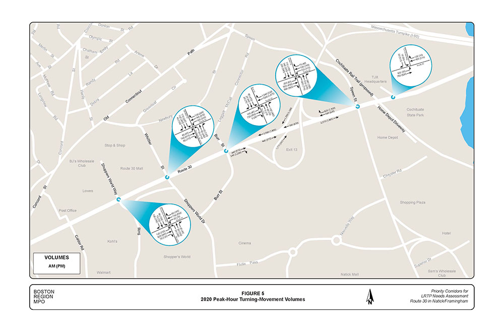
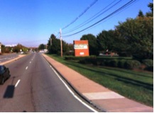
Install a two-to-three foot wide buffer between the roadway curb and existing sidewalks on Route 30 between Ring Road and Burr Street. A sidewalk buffer provides a comfortable separation and safety for pedestrians from the street and vehicles. A sidewalk buffer is desirable along Route 30 in the study area, where on-street parking is prohibited, and shoulders and bike lanes are absent. This improvement also could be considered as a mitigation project.
Pedestrian countdown signals improve safety by helping pedestrians make informed decision about crossing streets at signalized intersections. MPO staff recommends adding countdown displays to the existing pedestrian signal heads, especially on the traffic signal at the intersection of Route 30 and Ring Road/Shopper’s World Way, which appears to have the largest number of pedestrian crossings.
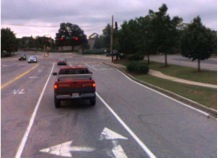
Install shared-lane markings (sharrows) in the rightmost through travel lanes on Route 30 to inform motorists to share the road, and reduce the speed limit to 35 mph from 40 mph. This also would benefit Cochituate Rail Trail users, as Route 30 would be one of the connecting roadways to the trail. Sharrows on Burr Street and Leggat McCall Connector Road would benefit bicyclists, if sidewalk Option 1 is selected.
Install bicycle detectors (video or loop) at the signalized intersections and provide bicycle detector pavement markings or signs indicating to bicyclists where to stop to wait for the green indication. Bicycle detectors at the intersection of Leggat McCall Connector Road and Speen Street would benefit bicyclists, if sidewalk Option 1 is selected.
These treatments could be extended east and west of the study area in order to increase benefits and effectiveness.
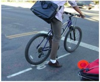
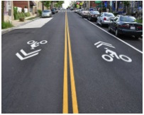
Traffic signals on Route 30 from Beacon Street to Burr Street in Framingham were retimed and coordinated in 2007, in order to establish efficient traffic flow processing. Using Synchro Studio, MPO staff evaluated the new timing plans, including those for signals at the Speen Street and TJX Companies driveway. The process was performed for both the AM and PM peak periods; and the results—including intersection levels of service, delays, and queues—are presented in Table 5. The results show that:
The segment of Route 30 with the two-way left-turn lane had a large number of angle-type crashes involving motorists turning into or out of driveways, with primary contributing factors as failure to yield right-of-way and changing lanes. This segment carries an ADT of 40,000-to-44,000 vehicles per day (both directions). TWLTLs are less effective and have high crash rates in locations where there is a density of commercial closely spaced driveway. In addition, TWLTLs start to lose their effectiveness when traffic volumes on a roadway are high—studies indicate that operating degradation occurs between an ADT of 24,000-to-28,000 vehicles per day (both directions).6,7
MPO staff suggests the following safety improvement options for consideration (Figure 9):
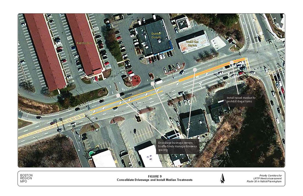
Currently, the Route 30 and Speen Street intersection is operating at capacity during peak periods; and analysis shows that a traffic signal retiming strategy likely would not improve capacity. Peak period traffic demands at the intersection are so high that a traffic queue is created on each approach, which last for two hours or more.
In addition, wetlands and businesses adjacent to the intersection place constraints on further widening the roadway. An evaluation of traffic flow patterns in the vicinity of the intersection indicated that on average, about 70 percent of traffic heading westbound on Route 30 just west of the Speen Street intersection proceeds to the MassPike. Based on this observation, MPO staff expects that the majority of the high-volume northbound left-turn, southbound right-turn, and, to a lesser degree, westbound straight-through traffic at the Speen Street intersection are destined to the MassPike.
In addition, MassDOT proposes to convert and replace the I-90 Western Turnpike interchange-based manual cash and electronic toll collection systems with its new All Electronic Tolling system. The project will include both roadway tolling infrastructure and toll collection system technology. Discussions with MassDOT Highway Division District 3 officials indicated that the District is interested a global approach to alleviate congestion at Route 30 and Speen Street intersection
MPO staff developed one medium- and five long-term improvement concepts for consideration (Figures 10 through 15), each of which would need further analysis to determine their effect on congestion, access to businesses, and the environment.
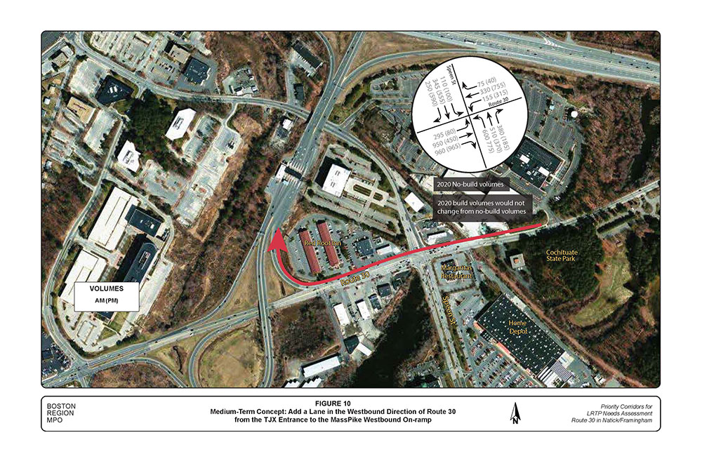
At the recommendation of the task force, MPO staff tested the addition of a traffic lane in the westbound direction of Route 30 from the TJX driveway through the Speen Street intersection, continuing as a third lane west of Speen Street up to the existing I-90 on-ramp, which would be reconstructed as two lanes (Figure 10).
Intersection analysis (Appendix D) showed that the level of service at the Route 30 and Speen Street intersection would improve slightly and delays per vehicle and queues would be reduced by as much as 20% and 40%, respectively. The exact reductions vary with peak period, approach, traffic movement, and traffic signal design parameters.
The addition of a third through lane westbound would have impacts in the areas of right-of-way and safety:
In order for the medium-term improvement to work successfully, MPO staff recommends that the two-way left-turn lane in the segment just west of Speen Street be replaced with a raised median, and access/egress to business driveways is restricted to right-turn-in and right-turn-out only.
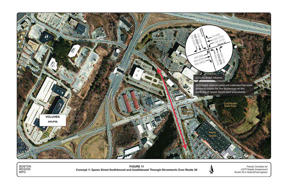
Concept 1: Speen Street northbound and southbound through movements over Route 30 (Figure 11). Figure 11 shows only 2020 no-build volumes because peak-period driveway volumes to/from the businesses on the north leg of Speen Street were not available for estimating 2020 build volumes.8
Concept 1 would reduce congestion at the Route 30 and Speen Street intersection because the new bridge would take Speen Street through traffic out of the intersection, and the savings in green time could be allocated to other movements at the intersection in order to reduce congestion. Concept 1 would have impacts in the areas of right-of-way and access and egress, particularly on the north leg of Speen Street. The width of the right-of-way on the north leg of Speen Street varies from 40 feet to 90 feet wide, and it would not provide enough space to accommodate a two-lane bridge plus access roads for the businesses. In addition, the bridge would restrict access and egress to businesses on the north leg of Speen Street to right-turn-in and right-turn-out only.
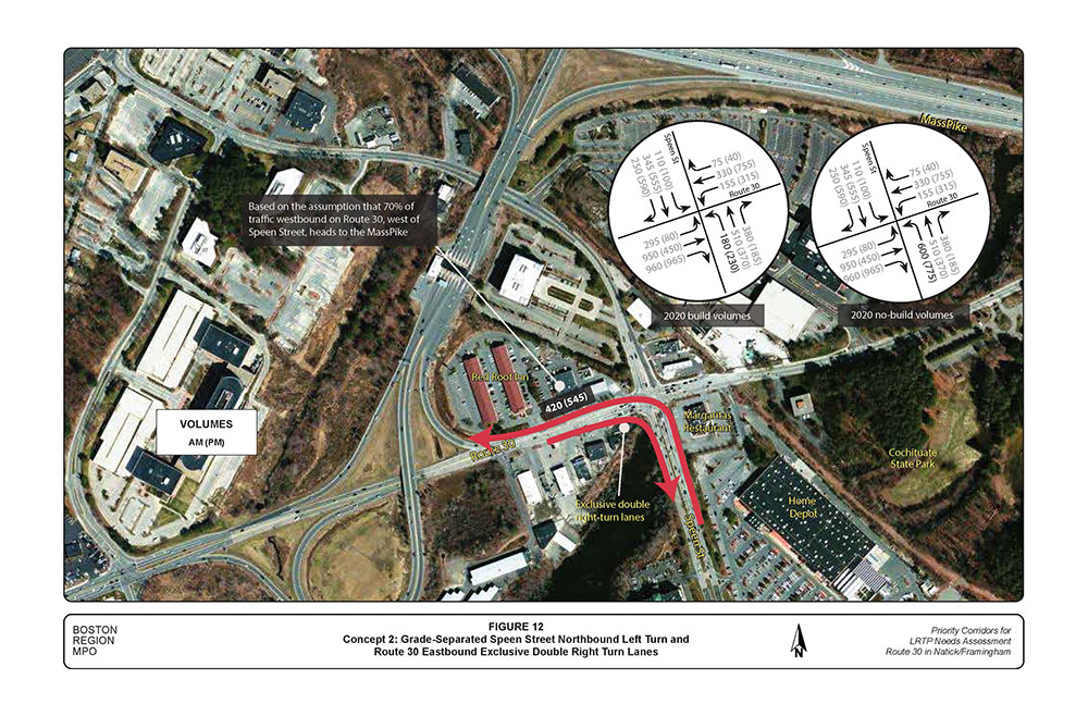
Concept 2: Grade-separated Speen Street northbound left turn and Route 30 eastbound exclusive double right-turn lanes (Figure 12). As part of Concept 2, the MassPike westbound on-ramp would be reconstructed as two lanes. An evaluation of traffic flow patterns in the vicinity of the Route 30/Speen Street intersection indicated that on average, about 70 percent of traffic heading westbound on Route 30 west of the Speen Street intersection proceeds to the MassPike. Consequently, the 2020 build volumes presented in Figure 12 are based on the assumption that about 70 percent of the Speen Street northbound left-turn movement would head to the MassPike via the grade-separation.
Concept 2 would reduce congestion at the Route 30/Speen Street intersection because the grade-separation would take the majority of the high-volume Speen Street northbound left turns out of the intersection, and the savings in green time could be allocated to other movements at the intersection in order to improve traffic operations. Concept 2 would have impacts in the areas of right-of-way and access and egress to businesses along Route 30, including Dunkin’ Donuts and Red Roof Inn. The right-of-way on Route 30 where the new overpass would land is approximately 100 feet wide and it would not provide enough space to accommodate existing travel lanes and landing of the new overpass (one travel lane, 28 feet wide from parapet to parapet). The overpass would also restrict access and egress to businesses on the north side of Route 30.
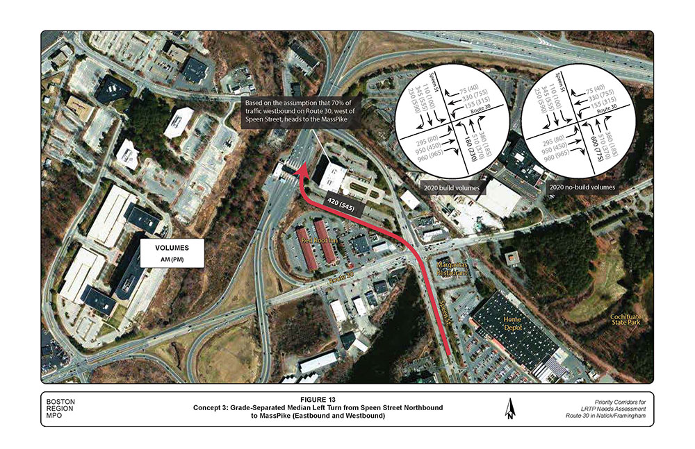
Concept 3: Grade-separated median left turn from Speen Street northbound to MassPike (eastbound and westbound) (Figure 13). The 2020 build volumes and ramp volumes presented in Figure 13 are based on the same assumption described in Concept 2. In addition, Concept 3 would reduce congestion at Route 30/Speen Street intersection in the same way as in Concept 2.
Concept 3 would have impacts in the area of right-of-way because its construction would require land taking in the northwest quadrant of the intersection, which would impact properties of the Red Roof Inn and the building at 111 Speen Street. In addition, the right-of-way on the south leg of Speen Street varies in width from about 100 feet in the Framingham segment to about 80 feet in the Natick segment, which is not sufficient to accommodate two travel lanes in each direction plus grade-separation (one travel lane, 28 feet from parapet to parapet), horizontal clearances, shoulders, and sidewalks.
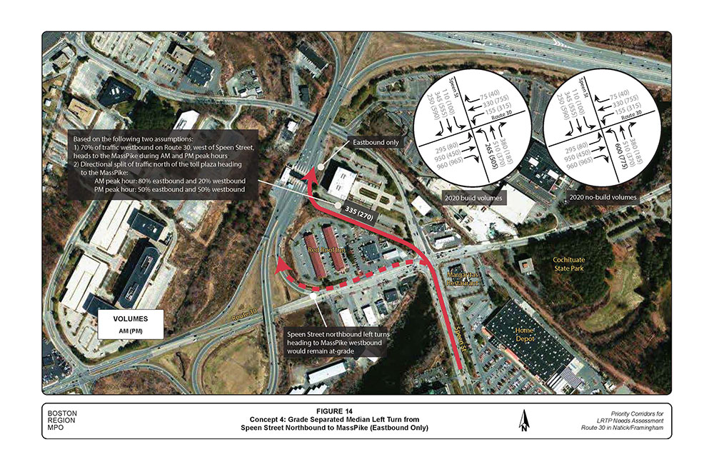
Concept 4: Grade-separated median left-turn from Speen Street northbound to MassPike (eastbound only) (Figure 14). The 2020 build volumes in Figure 14 are based on following two assumptions:
Concept 4 would reduce congestion at the Route 30/Speen Street intersection in the same way as in Concept 3. In addition, Concept 4 would have similar impacts in the area of right-of-way as in Concept 3.
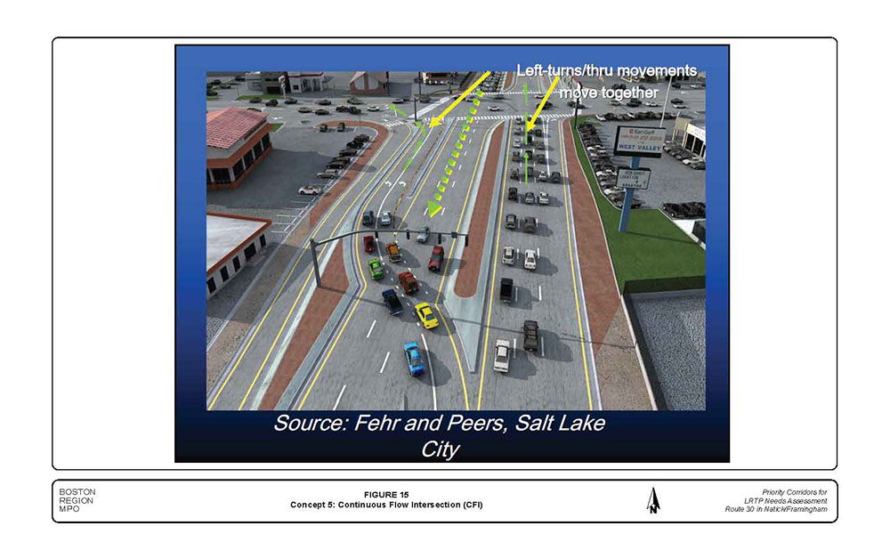
Concept 5: Convert the south leg of Speen Street into a continuous-flow intersection (Figure 15).
A continuous-flow intersection allows opposing left turns and through movements to take place simultaneously using one signal controller at the main intersection. For example, while east-west traffic on Route 30 is moving, northbound, left turns on Speen Street cross over oncoming traffic at a mid-block intersection. When the north-south signals on Speen Street turn green, both through and left-turn movements can go at the same time, because left-turn movement is already on the opposite side of the opposing through movement.
Concept 5 would reduce congestion at the Route 30/Speen Street intersection by servicing both through and left-turn movements at the same time. Concept 5 would have an impact in the area of right-of-way on the south leg of Speen Street. For efficient traffic operations, it is expected that in Concept 5 there would be two left-turn lanes, two through lanes in each direction, and an additional lane on the south leg of Speen Street to receive the high-volume of eastbound Route 30 right turns, which be a free-turn type. Currently, the AM and PM peak hour volumes for the eastbound Route 30 right turns are: 930 vehicles and 935 vehicles, respectively.
Considering the seven travel lanes in addition to median/traffic islands to separate or channel traffic, sidewalks, and utilities, the existing right-of-way (80 to 100 feet wide) would not be sufficient. More space on the south leg of Speen Street would therefore be needed to construct the improvements.
Table 6 presents results of the initial qualitative evaluation of the long-term concepts in terms of congestion reduction, access to businesses, and impacts on wetland, right-of-way, and aesthetics. MPO staff did not perform modeling and LOS analyses for the five long-term concepts because those tasks were not included in the work program for this study.
The Route 30 and Speen Street intersection is the most critical intersection in the study area. Retiming this intersection would only provide short-term benefits, hence other strategies providing medium- and long-term benefits would be needed to address safety and traffic operations problems and provide relief to adjacent intersections.
A medium-term solution that adds a lane in the westbound direction from the TJX driveway to the MassPike on-ramp, which would be constructed as two lanes, was tested by MPO staff and found to improve intersection levels of service slightly but delays per vehicle and queues would be reduced by as much as 20% and 40%, respectively.
MPO staff recommends that the Towns of Framingham and Natick advance the long-term concepts toward further analysis and design by working closely with MassDOT to tie the medium- and long-term improvements at the Route 30 and Speen Street intersection with MassDOT’s AET project.
TABLE 6
Comparison of Long-Term Concepts
Concept Description |
Impact on Access and Egress |
Impact on Wetland |
Constructability |
Impact on Right-of-Way |
Aesthetic/Visual Impacts |
Impact on Traffic Operations |
Cost |
Concept 1—Speen Street over Route 30 (northbound and southbound) |
Impacts access and egress to businesses on the north leg of Speen Street because of vertical clearance for landing the new bridge |
Some wetland impacts. Grade separation of the northbound and southbound movements would require more space in the median of Speen Street to construct, which may impact adjacent wetland. |
There is limited area on Speen Street for construction staging and traffic work zones, especially on the north leg.
Traffic management during construction could worsen congestion on Speen Street and Route 30. |
Requires land takings on Speen Street. The width of the new bridge plus clearances and travel lanes to service other at-grade movements at the Route 30/Speen Street intersection would require more space on Speen Street to construct. On the south leg of Speen Street, the right-of-way varies from 80 feet in the Natick segment to 100 feet wide in the Framingham segment. On the north leg of Speen Street the right-of-way varies from about 40 feet to 90 feet wide. |
Grade separation (overpass) presents aesthetics and visual impacts, as the aesthetic appeal of bridges is becoming increasingly important to people. Minimizing or preventing negative visual impacts because of new overpass is expected in this concept. |
Would reduce congestion at Route 30 and Speen Street intersection. The new overpass will take the majority of the Speen Street through traffic out of the intersection. The savings in green time would be allocated to Route 30 and left turns on Speen Street to improve traffic operations. |
High-cost improvement because of grade separation. |
Concept 2—Grade- Separated Speen Street Northbound Left Turn and Route 30 Eastbound Exclusive Right Lanes. |
Impacts access and egress to businesses in the northwest quadrant (Red Roof Inn, Sherwin William, Dunkin’ Donuts, and Mobil) with driveways access on Route 30. Vertical clearance required for landing the new bridge would make access to those businesses very difficult. In addition, access on Speen Street to the Margaritas restaurant would be affected. |
Minimal wetland impacts. In this concept, Speen Street northbound left turns would exit from the right hand side, which would reduce impact on wetland in the southwest quadrant of the intersection. |
There is limited area for construction staging and traffic work zones on Speen Street and Route 30.
Traffic management during construction could worsen congestion on Speen Street and Route 30. |
Requires land taking in the northwest and southeast quadrants. On the west leg of Route 30, the right-of-way is about 100 feet wide, while on the south leg of Speen Street the right-of-way varies from 80 feet wide in the Natick segment to 100 feet wide in the Framingham segment. |
Grade separation (overpass) presents aesthetics and visual impacts, as the aesthetic appeal of bridges is becoming increasingly important to people. Minimizing or preventing negative visual impacts due to bridge is expected in this concept. |
Require construction of a two-lane on-ramp to the MassPike to plaza to avoid a traffic merge on the westbound on-ramp.
Would reduce congestion at Route 30/ Speen Street intersection. The new overpass will take the majority of the high-volume Speen Street northbound lefts out of the intersection. The savings in green time would be allocated to Route 30 and Speen Street movements to improve traffic operations. |
High-cost improvement because of grade separation. |
Concept 3—Grade- Separated Median Left Turn from Speen Street Northbound to MassPike (eastbound and westbound) |
Does not affect existing access and egress from businesses on Route 30 or Speen Street.
The grade separation is located in the median on the south leg of Speen Street. It connects to the MassPike in the northwest quadrant of Route 30 and Speen Street intersection to avoid negative impacts on access and egress to businesses. |
Minimal wetland impacts, grade separation of the northbound left turn would require slightly more space in the median of Speen Street to construct, which may impact adjacent wetland. |
Construction staging in the median of busy Speen Street may prove difficult because of limited space. In addition there is limited area on Speen Street for traffic work zones. Management of traffic during construction could worsen congestion on Route 30 and Speen Street. |
Requires land takings in the northwest quadrant, which would affect properties of Red Roof Inn and the office building at 111 Speen Street. In addition, it would require land taking on the south leg of Speen Street; on the south leg of Speen Street the right-of-way varies from 80 feet wide in the Natick segment to 100 feet wide in the Framingham segment. |
Grade-separation (overpass) presents aesthetics and visual impacts, as the aesthetic appeal of bridges is becoming increasingly important to people. Minimizing or preventing negative visual impacts because of new overpass is expected in this concept. |
Connection to the MassPike may introduce a tight curve because of the alignment of the new ramp.
Traffic heading to MassPike westbound would have to weave across a travel lane, which could slow down traffic or create safety problems. With the all-electronic-toll system, traffic is expected to move faster and reduce congestion at the toll plaza.
Would reduce congestion at Route 30 and Speen Street intersection. The new overpass will take the majority of the high-volume Speen Street northbound lefts out of the intersection. The savings in green time would be allocated to Route 30 and Speen Street movements to improve traffic operations. |
High-cost improvement because of grade separation. |
Concept 4—Grade-Separated Median Left-Turn from Speen Street Northbound to MassPike (eastbound only) |
Concept 4 is a variation of Concept 3 and it does not affect existing access and egress from businesses on Route 30 or Speen Street. |
Minimal wetland impacts, grade separation of the northbound left turn would require slightly more space in the median to construct, which may impact adjacent wetland. |
Construction staging in the median of busy Speen Street may prove difficult. In addition there is limited area for traffic work zones. Management of traffic during construction could worsen congestion on Route 30 and Speen Street. |
Requires land takings in the northwest quadrant of Route 30 and Speen Street intersection, which may affect properties of Red Roof Inn and office building at 111 Speen Street. In addition, it would require land taking on the south leg of Speen Street; on the south leg of Speen Street the right-of-way varies from 80 feet wide in the Natick segment to 100 feet wide in the Framingham segment. |
Grade separation (overpass) presents aesthetics and visual impacts, as the aesthetic appeal of bridges is becoming increasingly important to people. Minimizing or preventing negative visual impacts because of new overpass is expected in this concept. |
Connection to the MassPike may introduce a tight curve because of the alignment of the new ramp.
Concept 4 avoids traffic weaving across to proceed to MassPike westbound; however, it would be difficult to prohibit/prevent motorists on the new ramp from doing so.
Concept 4 may not reduce congestion at Route 30 and Speen Street intersection during the PM peak period; because about 50% of the northbound Speen Street left turn movement would be expected to head westbound on the MassPike during the PM peak period. |
High-cost improvement because of grade separation. |
Concept 5—Continuous Flow Intersection on the South Leg of Speen Street |
Would not impact access and egress to businesses at the Route 30 and Speen Street intersection because the improvement would be constructed only on the south leg of Speen Street. |
Some wetland impacts; the improvement would require widening on the south leg of Speen Street in order to provide a free right turn for the high-volume Route 30 eastbound right turn movement. |
Does not appear to present traffic management problems during construction, as the improvement involves mainly the reconfiguration of the Speen Street northbound left turn lanes by moving them to the left of the opposing through lanes. |
Requires land takings along the south leg of Speen Street. For efficient operations, providing free right turns from Route 30 eastbound and maintaining proper alignment of the Speen Street through movements would require more space on the south leg of Speen Street. |
Does not involve grade separation; all movements at the intersection will remain at-grade. |
Would reduce congestion at the Route 30 and Speen Street intersection because the Speen Street northbound left and through movements can be serviced at the same time.
May result in a longer crosswalk on the south leg of Speen Street, which may affect pedestrians. |
Low-cost improvement, involves no grade separation. |
Source: Central Transportation Planning Staff.
Four different crossing alternatives were analyzed as part of this study:
The first three alternatives were analyzed qualitatively in a CRT study conducted for the Town of Natick in 2009.9 The detour diversion distances involved with Alternative 1 and Alternative 2 are 700 feet and 1150 feet, respectively.
Trail usage counts are important for planning, especially for trail-highway crossings. The Boston Region MPO estimates trail usage based on the number of people living within one-half mile of the trail (population), the number of people who walk and bicycle in the community, the number and places of employment within a mile of the trail, and usage on other nearby trails. See Appendix F for the 2007 trail user counts on trails across Massachusetts. The Boston Region MPO projects that the CRT could generate about 100 trail users (all types of users combined) during peak hours on weekend day, and about 700 users per day. Table 7 presents safety impacts for trail users for each crossing alternative.
In summary, the notable safety impacts include but are not limited to:
MPO staff analyzed the traffic operations impacts of each crossing alternative and the results of the analysis presented in Table 8.
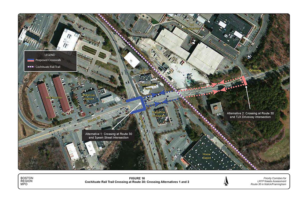
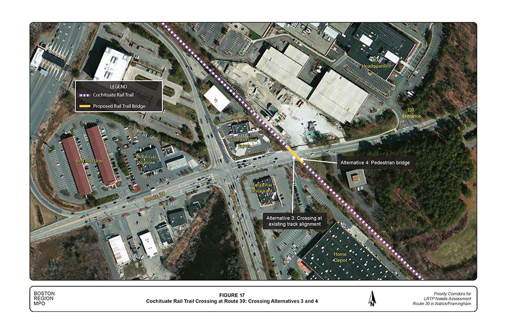
MPO staff analyzed four crossing options to improve safety for trail users at the Route 30 crossing.
The study of the Route 30 segment between the TJX driveway and the intersection at Ring Road/Shopper’s World Way examined existing conditions and identified short- and long-term improvement concepts.
The main concerns in this segment relate to connections to the MassPike; peak hour delays and queues, especially at the Route 30/Speen Street intersection during the PM peak period; an incomplete network for bicyclist and pedestrian circulation, including crossing the Cochituate Rail Trail at Route 30, east of Speen Street; and congestion and safety concerns related to driveway access, including the TJX driveway.
The study identified three options for closing the gaps in the existing bicycle and pedestrian circulation, including recommendations for signs and markings; traffic signal retiming schemes at four signalized intersections; traffic management options for the Route 30 segment between Speen Street and the MassPike on-ramp; and, six medium- and long-term concepts for reconfiguring the connection of Speen Street and Route 30 to the MassPike, including adding a westbound traffic lane to Route 30 from the TJX driveway to the I-90 connector.
Long-term improvements in the studied Route 30 segment hinge upon improved regional connections between the MassPike and the local network that serves Framingham and Natick, and other municipalities. Examining the design and feasibility of various connection options of Route 30 and Speen Street to the MassPike is particularly timely. MassDOT is planning to remove the toll plazas throughout the MassPike by replacing them with MassDOT’s All Electronic Tolling system. Connection options to I-90 from Framingham and Natick should be designed including the parameters and assumptions built into MassDOT’s AET project.
SAA/saa
Encl.
cc: Paul Nelson, MassDOT Office of Transportation Planning
Joseph Frawley, MassDOT Highway Division, District 3
Jeremy Marsette, Town Engineer, Framingham
Patrick Reffett, Community Development Director, Natick
FIGURES
Figure 1: Study Area Map
Figure 2: Land Use Map
Figure 3: Bicycle and Pedestrian Issues
Figure 4: Existing Peak-Hour Turning Movement Volumes
Figure 5: 2020 Peak-Hour Turning Movement Volumes
Figure 6: Option 1: Use Existing Sidewalks on Burr Street, Leggat McCall Connector Road, and Speen Street
Figure 7: Option 2: Continuous and Connected Sidewalks on South Side of Route 30
Figure 8: Option 3: Continuous and Connected Sidewalks/Multiuse Path on South Side of Route 30 and Outer Loop of MassPike Connector
Figure 9: Consolidate Driveways and Install Median Treatments Cochituate Rail Trail Crossing at Route 30: Crossing Alternatives
Figure 10: Medium-Term Concept: Add a Lane in the Westbound Direction of Route 30 from the TJX Entrance to the MassPike Westbound On-ramp
Figure 11: Concept 1: Speen Street Northbound and Southbound Through Movements over Route 30
Figure 12: Concept 2: Grade-Separated Speen Street Northbound Left Turn and Route 30 Eastbound Exclusive Double Right Turn Lanes
Figure 13: Concept 3: Grade-Separated Median Left Turn from Speen Street Northbound to MassPike (Eastbound and Westbound)
Figure 14: Concept 4: Grade Separated Median Left Turn from Speen Street Northbound to MassPike (Eastbound Only)
Figure 15: Concept 5: Continuous Flow Intersection (CFI)
Figure 16: Cochituate Rail Trail Crossing at Route 30: Crossing Alternatives 1 and 2
Figure 17: Cochituate Rail Trail Crossing at Route 30: Crossing Alternatives 3 and 4
APPENDIXES
The following appendices are not in an accessible format. If you need assistance accessing this information, please contact CTPS at 617-973-7098.
Appendix A: Turning Movement and Automatic Traffic Recorder Counts
Appendix B: Traffic Signal Timing Information and As-Built Traffic Signal Plans
Appendix C: Crash Rates Worksheets and Collision Diagrams
Appendix D: Intersection Capacity and Levels of Service Analyses
Appendix E: Mitigation Improvements and Actions for Route 30
Appendix F: Trail User Counts on various Trails in Massachusetts
1 The AM peak period is 7:00 AM to 9:00 AM, and the PM peak period is 4:00 PM to 6:00 PM.
2 Boston Region Metropolitan Planning Organization, Unified Planning Work Program, Federal Fiscal Year 2013, Endorsed by the Boston Region Metropolitan Planning Organization on June 28, 2012.
3 ATR counts are 24-hour counts conducted at a location for two or more consecutive days.
4 Trafficware Inc., Synchro Studio 8, Snychro plus SimTraffic, Build 801, Version 563, Sugar Land, Texas.
5 EMME 3, Transport Modeling, INRO, Westmount, Montreal, Quebec, Canada.
6 Iowa State University, Iowa Access Management Research and Awareness Project, CTRE, 1997.
7 Peter S. Parsonson, Development of Policies and Guidelines Governing Median Selection, School of Civil Engineering, Georgia Institute of Technolog Sponsored Research Project No. E-20-841,1990.
8 Total average traffic growth in the study area is projected to be approximately 3.0 percent by 2020; this factor was used to expand existing peak-hour turning-movement volumes into 2020 future turning-movement volumes.
9 Town of Natick, MA, Cochituate Rail Trail, Conceptual Design Study, by Fay, Spofford & Thorndike, Draft November 2009.