Technical Memorandum
DATE: May 21, 2015
TO: Larry Dunkin, Town Planner, Milford
FROM: Seth Asante, MPO Staff
RE: Safety and Operations Analyses—Milford
Selected Intersection: Medway Road at Kmart Driveway in Milford
This memorandum summarizes the analyses and improvement strategies developed for the section of Route 109 near the Kmart and McDonald’s driveways in Milford. The opening sections of the memorandum give a background of the study and describe the existing conditions and problems of concern to the community. Following that is an assessment of the safety and operations problems and potential improvement strategies. The final sections of the memo present the study recommendations. This memo also includes technical appendices that contain methods and data applied in the study and detailed reports of the intersection capacity analyses.
The purpose of the Safety and Operations Analyses at Selected Intersections study is to examine mobility and safety issues at major intersections in the Boston Region Metropolitan Planning Organization (MPO) area’s arterial highways; where many crashes occur, roadways experience congestion, or need improvements for buses, bicyclists, and pedestrians. For the past ten years, the MPO has been conducting these planning studies, and municipalities are very receptive to them. These studies give municipalities an opportunity to look at the needs of these sites, starting at the conceptual level, before they commit funds for design and engineering. Eventually, if the project qualifies for federal funds, the study’s documentation also is useful to the Massachusetts Department of Transportation (MassDOT). The studies support MPO visions and goals, which include increasing transportation safety, maintaining the transportation system, reducing congestion, and advancing mobility and access management.
After an initial selection process1, the Boston Region MPO approved four locations (from a short list of 21 intersections) for study based on a series of criteria including, high crash rating, number of pedestrian and bicycle crashes, transit significance2, regional significance3, and implementation potential.4 The four locations approved for study are:
The Milford location was selected because it experiences safety problems and is on MassDOT’s Statewide 2010‒2012 Top-200 Intersection Crash List.
MPO staff worked with the Milford Town Planner, Larry Dunkin, to finalize study’s work scope, existing conditions and problems, and proposed improvement concepts. The town provided crash data, developments expected in the study area, and previously discussed improvement concepts. The study documents were reviewed by the town planner and MassDOT Highway Division District 3 staff. Appendix A presents MassDOT’s comments, which have been addressed and incorporated into this memorandum.
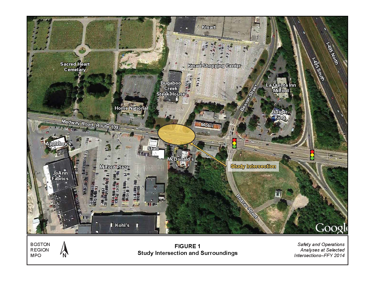
Route 109 is predominantly a two-lane, two-way arterial roadway that passes through eight communities from east to west: Dedham, Westwood, Dover, Walpole, Medfield, Millis, Medway, and Milford. Although Route 109 is a state-numbered route, it is locally controlled. The roadway, functionally classified as a principal arterial, is part of the National Highway System (NHS) program and is eligible for federal funds. In Milford, Route 109 is called Medway Road and it provides access to/from I-495 and communities east of Milford. Medway Road near Kmart Driveway features two 11-foot-wide travel lanes in each direction and five-foot continuous, connected sidewalks on the south side of Medway Road. The right-of-way varies between 50 and 60 feet. The posted speed limit is generally 30 miles per hour (mph) in both directions. Figure 1 presents an aerial image of the study area. Because of its close proximity, MPO staff has included the intersection of Medway Road and Beaver Street in the analysis.

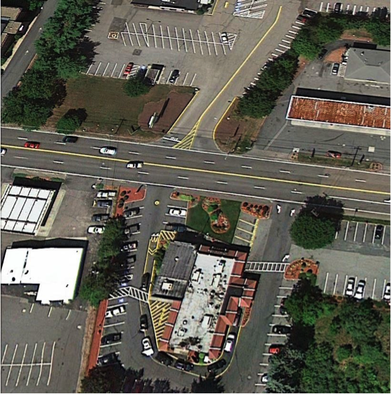
Medway Road and the driveways for Kmart and McDonald’s form a four-legged unsignalized intersection (Figure 1). Motorists can access both driveways from each direction on Medway Road. Motorists exiting from the Kmart driveway can only turn right and head westbound on Medway Road. McDonald’s driveway (directly across from Kmart’s driveway) is designated “enter only”—motorists exiting from McDonald’s have a separate “exit only” driveway about 100 feet east of the entry driveway. Access to and from both driveways is challenging and associated with many crashes.
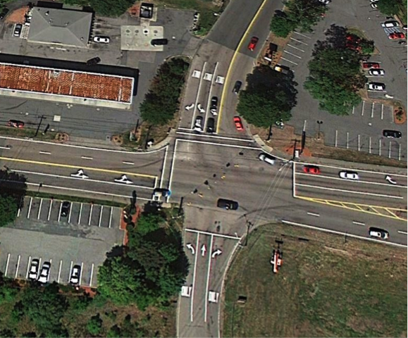
Medway Road and Beaver Street form a four-legged signalized intersection (Figure 1), which is located about 250 feet from the Kmart/McDonald’s intersection. The primary traffic flow through the intersection is along Medway Road. The traffic signal equipment is fully actuated and coordinated and has Opticom receivers to handle emergency services such as preempting traffic queues. The intersection has multi-lane approaches because of high traffic volume during peak periods.
Medway Road westbound approach widens to three lanes approximately 200 feet prior to the intersection and continues as two lanes through the intersection. Left turns are prohibited at the westbound approach so drivers access properties south of the intersections by turning left at the Birch Street intersection located to the west of this intersection. Medway Road eastbound approach has two lanes (a shared through/left lane and an exclusive through lane).
Beaver Street is one-way northbound; the northbound approach widens to three lanes (one lane each for turning left or right) approximately 200 feet prior to the intersection and continues as one past the intersection. The Beaver Street southbound approach widens to three lanes (two lanes for turning left and one lane for turning right).
The pedestrian signals are functioning well. Sidewalks (approximately five feet wide) are present along one side of Medway Road, and crosswalks are present on the west leg of Medway Road and the north leg of Beaver Street. The curb ramps do not meet Americans with Disability Act requirements as they lack detectable warning plates.
Land use in the area is zoned commercial (Figure 1). On the south side of Medway Road are a McDonald’s restaurant, Shell gas station, and the Milford Plaza, which contains a Kohl’s department store and several other stores and restaurants. On the north side of Medway Road is a Kmart, Bugaboo creek Steak House, Mobil gas station, and a Burger King restaurant.
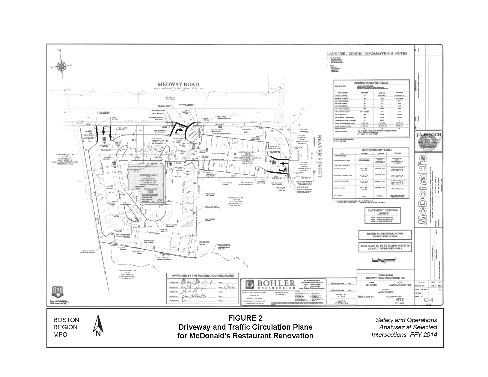
Recently, Milford approved development plans for renovation of McDonald’s, which allow for a new driveway off Beaver Street and converting the exiting driveway on Medway Road into a right-turn-only exit (Figure 2). In addition, the town is exploring ideas to convert Beaver Street’s south leg into a two-way roadway to allow development of land south of the Medway Road and Beaver Street intersection.
MPO staff collected traffic volume data to assess the study area’s operational characteristics (Appendix B). Staff also conducted turning-movement counts (TMCs) at the driveways and Beaver Street intersection in April 2014 during weekday morning and evening peak-travel periods from 7:00 to 9:00 AM and 4:00 to 6:00 PM. Staff counted heavy vehicles, including school buses and trucks, separately; pedestrian and bicycle counts were conducted simultaneously with the TMCs.
Based on the counts, staff estimated the average daily traffic (ADT) volume on Medway Road at between 27,300 and 31,500 vehicles per day. The ADT on Beaver Street was approximately 10,800 vehicles per day on the north leg and 5,300 vehicles per day on the south leg. Figure 3 shows the peak-hour turning movement volumes. During the AM peak travel period, the primary traffic flow (peak direction) is westbound on Medway Road, including a high volume of traffic turning right onto Beaver Street. During the PM peak travel period, the primary traffic flow direction is reversed—eastbound on Medway Road. In addition, a high volume of traffic southbound on Beaver Street turns left onto Medway Road; and a high-volume turns right northbound on Beaver Street. The presence of trucks in the study-area intersections during the AM and PM peak travel periods ranged between 6.0-and-7.0 percent, which is considered high for peak-period traffic conditions. Staff did not detect any roadway geometry—such as turning radii, which would inhibit truck traffic flow—other than the traffic congestion that exists during peak hours. Only one pedestrian was observed during the counting period. No bicyclists were observed during the counting period. High traffic volumes and absence of a residential area close to the intersections contributed to the low pedestrian and bicycle counts.
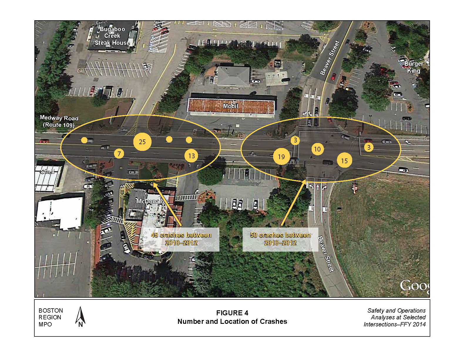
Staff obtained 2010-to-2012 crash records from the MassDOT Registry of Motor Vehicles (RMV). Table 1 presents a summary of crashes at each intersection in terms of severity, manner of collision, weather conditions, ambient light conditions, and time of occurrence. Between 2010 and 2012, 99 crashes were reported in the segment of Medway Road between the Kmart driveway and the Beaver Street intersection. This intersection is ranked 34th on the 2012 Statewide Top-200 Intersection Crash List; the intersection crash cluster used for the Kmart intersection includes the Beaver Street intersection.
Figure 4 shows the amount and location of the crashes; the Medway Road and Beaver Street intersection had 50 crashes and the segment of Medway Road between the Kmart driveway and Mobil gas station driveway had 49 crashes. The majority of the crashes (more than 70 percent) were angle-type crashes resulting from failing to yield the right of way or not using caution when entering an intersection. Appendix C contains the crash data and crash rate worksheets.
Staff calculated intersection crash rates using the MassDOT Highway Division methodology, based on the entire three-year period (shown at the bottom of Table 1). The most recent statewide average crash rate for intersections in MassDOT Highway Division District 3 (which includes the Town of Milford) is 0.89 crashes per million entering vehicles (mev) for signalized intersections and 0.66 crashes per mev for unsignalized intersections. The values are based on MassDOT RMV crash information queried on January 23, 2013. Crash rates for the Medway Road and Beaver Street intersection and the intersection of Medway Road and Kmart/McDonald’s driveways were significantly higher than the District 3 average crash rates for signalized and unsignalized intersections, respectively.
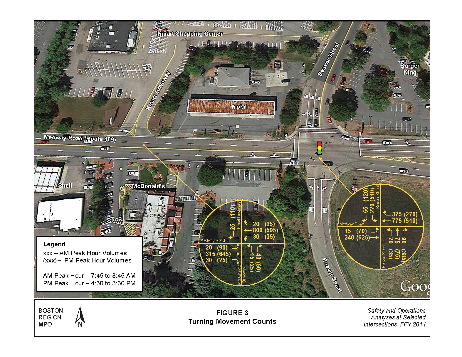
TABLE 1
Crash Summary (2010-2012)
Characteristics |
Kmart/McDonald’s Intersection |
Beaver Street Intersection |
|---|---|---|
Crash Severity |
-- |
-- |
Non-fatal injury |
6 |
4 |
Property damage only |
33 |
44 |
Not reported or unknown |
10 |
2 |
Manner of Collision |
-- |
-- |
Angle |
36 |
30 |
Rear-end |
4 |
12 |
Sideswipe, opposite direction |
1 |
0 |
Sideswipe, same direction |
0 |
5 |
Single vehicle collision |
2 |
1 |
Head-on |
1 |
0 |
Unknown |
5 |
0 |
Road Surface Condition |
-- |
-- |
Dry |
40 |
39 |
Wet |
6 |
10 |
Snow |
3 |
0 |
Not reported or unknown |
0 |
1 |
Ambient Light |
-- |
-- |
Daylight |
42 |
41 |
Dark - lighted roadway |
4 |
8 |
Dawn |
0 |
1 |
Dusk |
2 |
0 |
Not reported or unknown |
1 |
0 |
Weather Conditions |
-- |
-- |
Clear |
32 |
35 |
Cloudy |
10 |
5 |
Rain |
6 |
9 |
Snow |
1 |
0 |
Not reported or unknown |
0 |
1 |
Travel Period |
-- |
-- |
Peak period |
15 |
23 |
Off-peak period |
34 |
37 |
Total Crashes (2010-2012) |
49 |
50 |
Three-year average crash rate (rounded) |
16 |
17 |
Average crash rate |
2.92 |
1.59 |
MassDOT Highway Division District 3 average crash rate |
0.66 |
0.89 |
* The AM peak period is 7:00 AM to 9:00 AM, and the PM peak period is 4:00 PM to 6:00 PM.
Source: Central Transportation Planning Staff.
MPO staff used police crash reports obtained from the Milford Police Department to prepare a collision diagram useful for examining patterns and developing safety strategies. Figure 5 shows the collision diagram of the crashes. The numbers in the collision diagram uniquely identify each crash and, for more detail about the crash, may be used to cross reference the crash records provided in Appendix C. As seen in Figure 5, the majority of crashes involve:
Analyses of the police crash records indicated that many of the crashes at the intersection of Medway Road and the driveways for Kmart and McDonald’s were courtesy-type crashes. Courtesy crashes usually occur on roadways with two or more travel lanes in one direction—when motorists in the rightmost lane stop and allow traffic in business driveways to turn left across travel lanes and head in the opposite direction—oncoming drivers in the leftmost lane do not see other motorists entering the roadway and crashes occur. Similarly, when motorists in the left lane stop and allow traffic in the opposing direction to turn left into business driveways—oncoming drivers in the rightmost lane do not see them entering the roadway and crashes occur.
Using the data and information collected, MPO staff built a traffic analysis network for the AM and PM peak hours with Synchro to assess the capacity and quality of traffic flow at the intersections.5 The analyses were conducted in a manner consistent with the Highway Capacity Manual6 (HCM) methodologies (detail worksheets of the analyses are included in Appendix D).
The HCM methodology demonstrates the driving conditions at signalized and unsignalized intersections it in terms of levels of service (LOS) ratings from A through F. LOS A represents the best operating conditions (little to no delay), while LOS F represents the worst operating conditions (very long delay). LOS E represents operating conditions at capacity (limit of acceptable delay).
Table 2 shows the control delays associated with each LOS for signalized and unsignalized intersections. Table 3 presents the results of the LOS analysis in terms of delays and queues. The Medway Road and Beaver Street intersection operates satisfactorily during the AM peak period (LOS D or better). During the PM peak period the Beaver Street northbound movements experience high delay (LOS F). The intersection of Medway Road and the driveways of Kmart and McDonald’s operate desirably at LOS A during both peak periods.
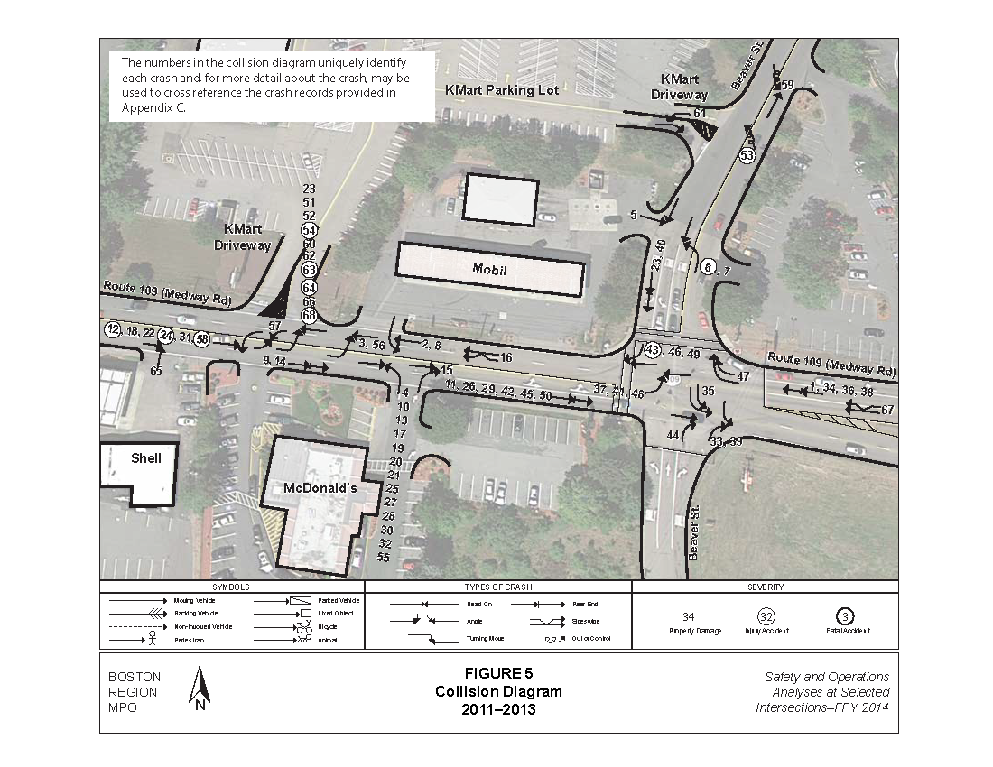
TABLE 2
Levels of Service and Control Delays at Intersections
Level of Service |
Signalized Intersections Control Delay |
Unsignalized Intersections Control Delay |
|---|---|---|
A |
≤ 10 |
≤ 10 |
B |
> 10-20 |
> 10-15 |
C |
> 20-35 |
> 15-25 |
D |
> 35-55 |
> 25-35 |
E |
> 55-80 |
> 35-50 |
F |
> 80 |
> 50 |
Source: Central Transportation Planning Staff.
To forecast, on a systematic basis, future traffic volume changes resulting from changes in the transportation network or in land use, a planning model is used. The transportation-planning model used in this study is the Boston Region MPO’s most recent regional travel demand model set used in the Long-Range Transportation Plan. Its socioeconomic components are based on forecasts produced by the Metropolitan Area Planning Council. The model is calibrated at a regional level for 164 cities and towns, including all of the 101 cities and towns in the MPO region. The primary tool used in model calibration is the transportation planning model set implemented TransCAD software. Based on the planning model, traffic on Medway Road is expected to grow at 0.33 percent per year, which results in a total traffic increase of 3 percent between 2014 and 2024.
TABLE 3
Existing LOS, Delay, and Queue at Peak Hours
Intersection/Approach |
Move |
AM LOS |
AM Delaya |
AM Queueb |
PM LOS |
PM Delay |
PM Queue |
|---|---|---|---|---|---|---|---|
Medway Road at Beaver Street |
-- |
-- |
-- |
-- |
-- |
-- |
-- |
Medway Road Eastbound |
L+T |
B |
10.6 |
84 |
B |
18.3 |
206 |
Medway Road Westbound |
T |
B |
12.5 |
192 |
B |
15.2 |
135 |
Medway Road Westbound |
R |
A |
2.4 |
42 |
A |
2.7 |
41 |
Beaver Street Northbound |
L |
D |
37.3 |
33 |
D |
35.1 |
48 |
Beaver Street Northbound |
T |
D |
44.2 |
85 |
D |
37.3 |
85 |
Beaver Street Northbound |
R |
D |
13.2 |
43 |
F |
137.2 |
#416 |
Beaver Street Southbound |
L |
C |
34.4 |
97 |
D |
44 |
211 |
Beaver Street Southbound |
R |
A |
1.8 |
12 |
A |
7.8 |
45 |
Total Intersection |
All |
B |
13.9 |
-- |
D |
39 |
-- |
Medway Road at Kmart and McDonald’s Restaurant Driveways |
-- |
-- |
-- |
-- |
-- |
-- |
-- |
Medway Road Eastbound |
L+T+R |
A |
0.7 |
0 |
A |
1.7 |
0 |
Medway Road Westbound |
L+T+R |
A |
0.5 |
0 |
A |
0.8 |
0 |
Kmart Entrance Southbound |
R |
B |
11.5 |
2 |
B |
11.7 |
12 |
Total Intersection |
All |
A |
0.7 |
-- |
A |
2 |
-- |
aDelay in seconds per vehicle. b 95th percentile queue length in feet. # = The 95th percentile volume exceeds capacity.
Source: Central Transportation Planning Staff.
Based on existing conditions analyses and discussions with the town planner, the problems in the study area are:
MPO staff developed and analyzed several short- and long-term strategies to improve safety and traffic operations. The projected growth factor from the regional model set was used to expand the existing peak-hour turning-movement volumes to 2024 future turning-movement volumes, which was used to test the improvement strategies. The improvement strategies that staff evaluated include:
Alternative 1 converts the driveway to Kmart into a right-in right-out channelization with a forced turn island (Figure 6). In addition, it incorporates the access and circulation plans proposed in the McDonald’s renovations. Alternative 1 has the following benefits:
Alternative 1 has the following disadvantages:
Table 4 shows the results of traffic operations analysis at the Beaver Street intersection, which indicates a desirable LOS D or better. Estimates of the safety benefit of Alternative 1 suggest as much as a 70-percent reduction in left-turn related crashes7. This low-cost improvement, consisting of a channelized island, signs, and signal retiming is estimated to cost about $50,000.
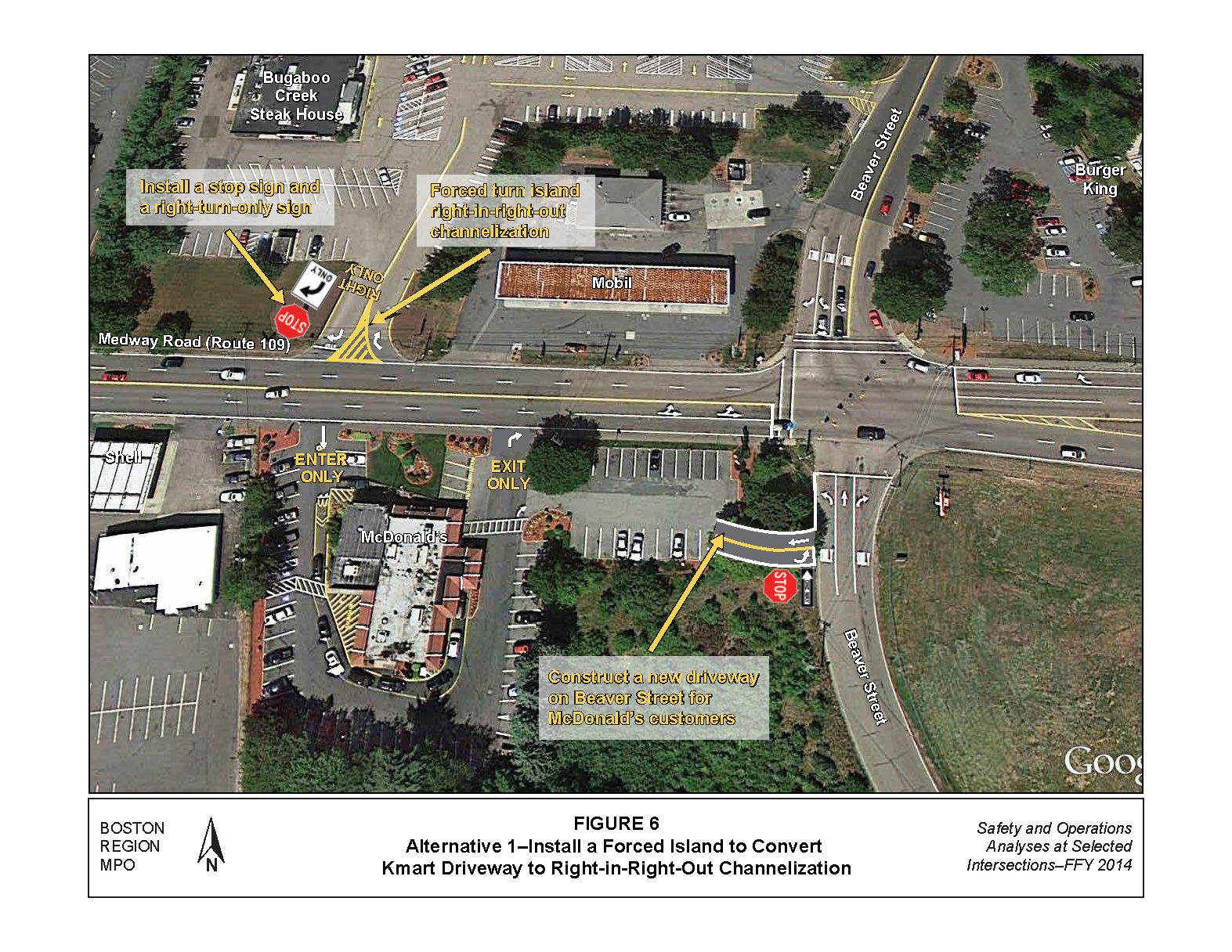
TABLE 4
Alternative 1: Future Year (2024) Peak-Hour Level of Service
Intersection/Approach |
Movement |
AM LOS |
AM Delaya |
AM Queueb |
PM LOS |
PM Delay |
PM Queue |
|---|---|---|---|---|---|---|---|
Medway Road at Beaver Street (Signal Control) |
-- |
-- |
-- |
-- |
-- |
-- |
-- |
Medway Road Eastbound |
L+T |
B |
11.5 |
94 |
C |
24.9 |
288 |
Medway Road Westbound |
T |
B |
13.3 |
200 |
B |
15.3 |
140 |
Medway Road Westbound |
R |
A |
2.5 |
42 |
A |
2.7 |
41 |
Beaver Street Northbound |
L |
D |
37.3 |
33 |
D |
35.2 |
49 |
Beaver Street Northbound |
T |
D |
44.6 |
87 |
D |
37.6 |
87 |
Beaver Street Northbound |
R |
B |
13.2 |
44 |
F |
164.3 |
#441 |
Beaver Street Southbound |
L |
D |
35.2 |
100 |
D |
45.2 |
#223 |
Beaver Street Southbound |
R |
A |
2 |
13 |
A |
7.7 |
46 |
Total Intersection |
All |
B |
14.4 |
-- |
D |
44.4 |
-- |
aDelay in seconds per vehicle. b 95th percentile queue length in feet. # = The 95th percentile volume exceeds capacity.
Source: Central Transportation Planning Staff.
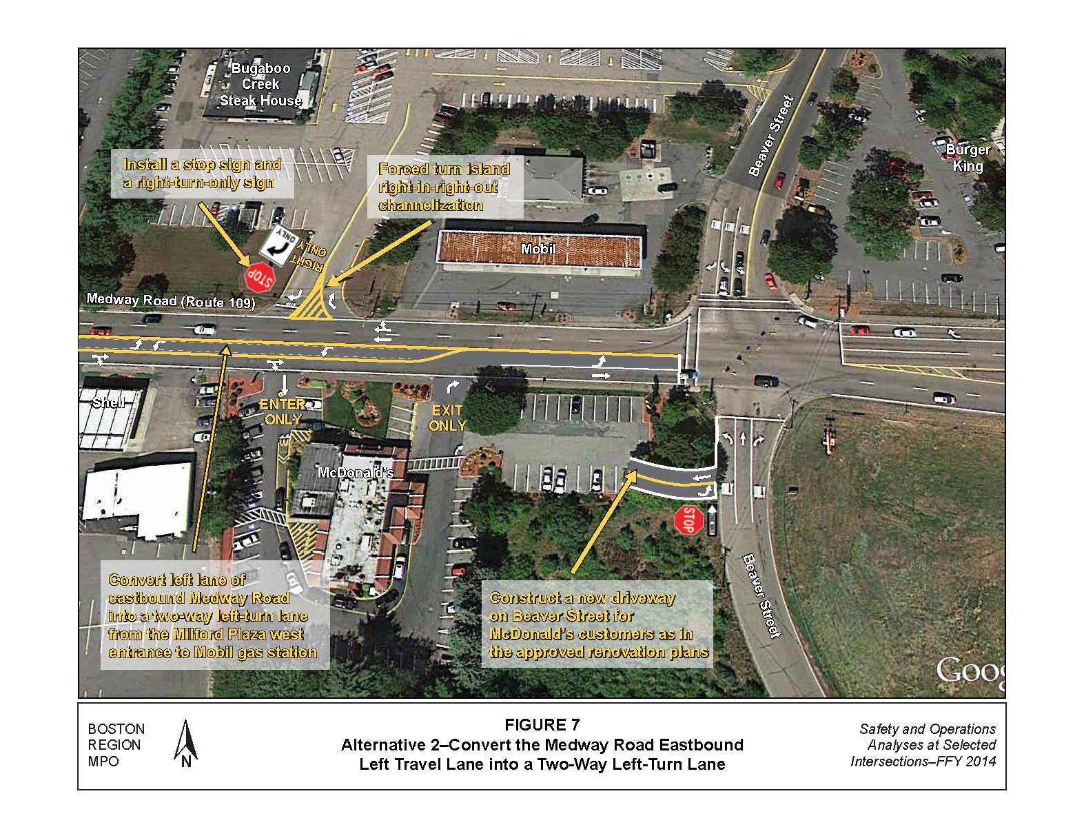
Alternative 2 converts the Medway Road eastbound left travel lane into a two-way left-turn lane to provide access to businesses on Medway Road. The TWLTL would extend from the Milford Plaza’s west entrance to the Mobil gas station. Alternative 2 includes the proposed access and circulation plans for the McDonald’s renovation and the right-in right-out channelization of Alternative 1.
Figure 7 shows the improvements proposed in Alternative 2, which provides the following benefits:
Alternative 2 limits access for Kmart customers eastbound on Medway Road as in Alternative 1.
Table 5 displays results of traffic operations analysis at the Beaver Street intersection, which indicates that Alternative 2 would operate at a desirable LOS D or better. Estimates of the safety benefit of prohibiting left turns at the driveway to Kmart suggest as much as a 70-percent reduction in left-turn related crashes; estimates of the safety benefit of a TWLTL suggest as much as a 37-percent reduction in crashes8. This low-cost improvement, consisting of pavement stripping, channelized island, and signal retiming would cost about $70,000.
TABLE 5
Alternatives 2 and 3: Future Year (2024) Peak-Hour Level of Service
| Intersection/Approach |
Move-ment |
AM LOS |
AM Delaya |
AM Queueb |
PM LOS |
PM Delay |
PM Queue |
|---|---|---|---|---|---|---|---|
Medway Road at Beaver Street (Signal Control) |
-- |
-- |
-- |
-- |
-- |
-- |
-- |
Medway Road Eastbound |
L |
B |
11.2 |
29 |
C |
30.8 |
155 |
Medway Road Eastbound |
T |
B |
12.1 |
185 |
D |
39.9 |
#579 |
Medway Road Westbound |
T |
B |
12.2 |
200 |
B |
18.9 |
156 |
Medway Road Westbound |
R |
A |
2.2 |
41 |
A |
3.4 |
46 |
Beaver Street Northbound |
L |
D |
41.3 |
34 |
C |
27.9 |
43 |
Beaver Street Northbound |
T |
D |
50.3 |
92 |
C |
29.2 |
77 |
Beaver Street Northbound |
R |
D |
14 |
46 |
E |
65.8 |
#394 |
Beaver Street Southbound |
L |
D |
41.1 |
108 |
E |
61.5 |
#266 |
Beaver Street Southbound |
R |
A |
7.4 |
26 |
A |
8.7 |
48 |
Total Intersection |
All |
B |
15.1 |
-- |
D |
38 |
-- |
aDelay in seconds per vehicle. b 95th percentile queue length in feet. # = The 95th percentile volume exceeds capacity.
Source: Central Transportation Planning Staff.
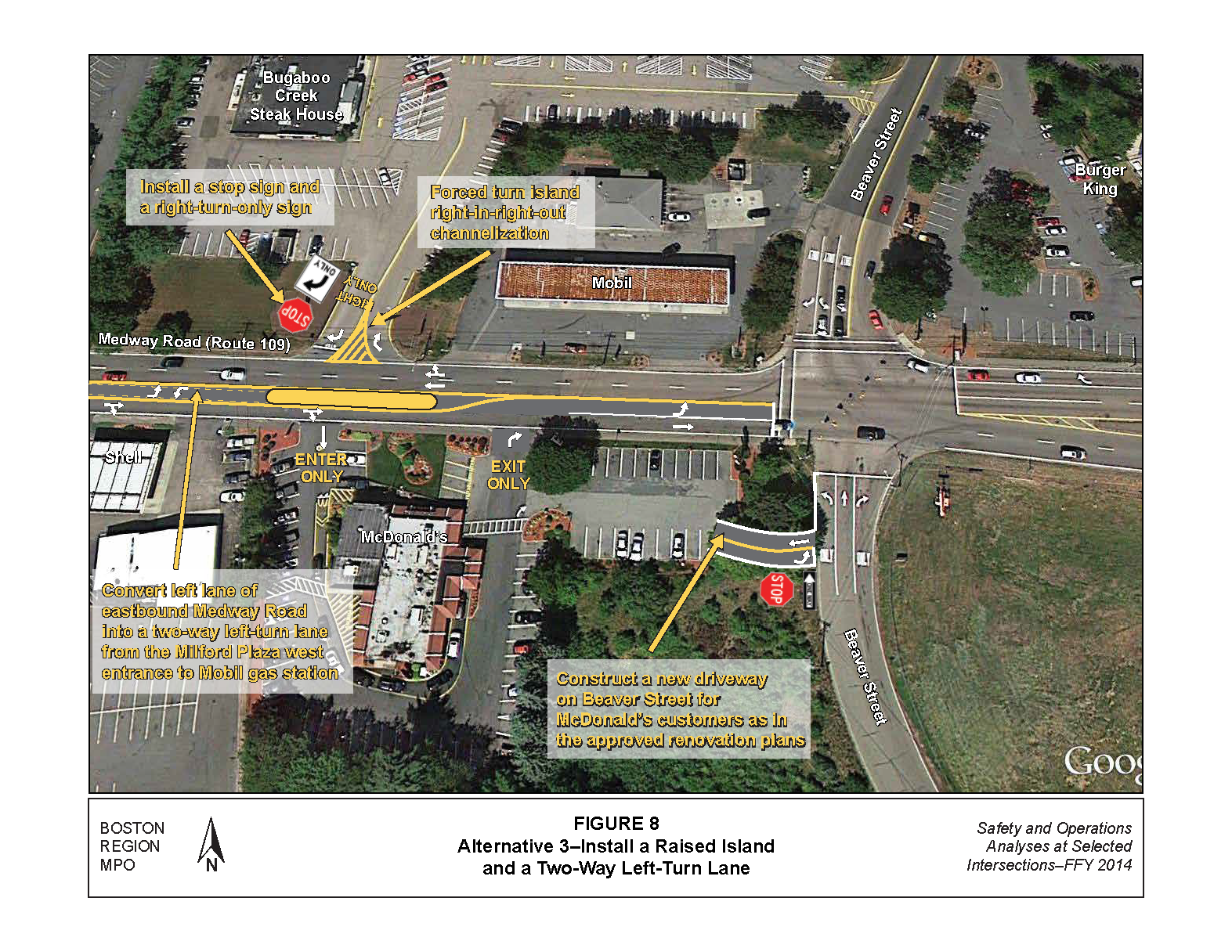
Alternative 3 is a variation of Alternative 2 to prohibit left turns from Medway Road to Kmart and McDonald’s with a raised median (Figure 8). Alternative 3 has the following benefits:
Alternative 3 has the following disadvantages:
Alternative 3 produces similar LOS at the Beaver Street intersection as in Alternative 2 (Table 5 above). Estimates of the safety benefit of a raised median suggest as much as a 70-percent reduction in left-turn related crashes and as much as a 44-percent reduction in injury-related crashes.9 It is estimated to cost approximately $80,000 to implement the improvements in Alternative 3.
Alternative 4 would install a new traffic signal at the intersection of Medway Road and the driveways to Kmart and McDonald’s and coordinates with nearby traffic signals to improve safety and access and operations (Figure 9). The proposal also incorporates new access and circulation plans for the McDonald’s renovation. Alternative 4 provides the following benefits:
Alternative 4 has the following disadvantages:
Apart from signal warrant 7—crash experience, intended for situations where the severity and frequency of crashes are the principal reasons to consider installing a traffic control signal, the remaining eight signal warrants might not be met given the low traffic volumes exiting the business driveways. Table 6 shows results of the traffic operations analysis, which indicates that the new traffic signal would operate at desirable level of service (LOS D or better). The safety benefits of installing a traffic signal suggest a 67-to-77 percent reduction in angle crashes and about a 38-percent increase in rear-end crashes.10 Installing a new traffic signal is a relatively high-cost improvement, estimated to cost approximately $1.5 million.
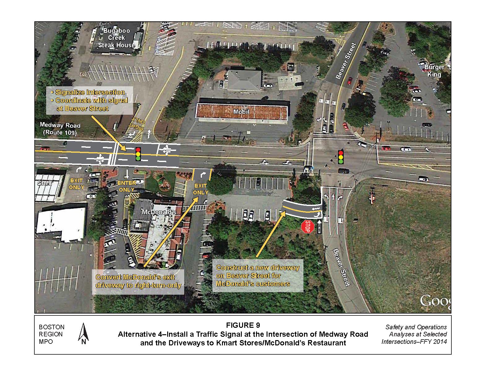
TABLE 6
Alternative 4: Future Year (2024) Peak-Hour Level of Service
Intersection/Approach |
Move-ment |
AM LOS |
AM Delaya |
AM Queueb |
PM LOS |
PM Delay |
PM Queue |
|---|---|---|---|---|---|---|---|
Medway Road at Beaver Street (Signal Control) |
-- |
-- |
-- |
-- |
-- |
-- |
-- |
Medway Road Eastbound |
L+T |
B |
10.2 |
86 |
C |
30.6 |
279 |
Medway Road Westbound |
T |
B |
12.2 |
200 |
C |
22.6 |
177 |
Medway Road Westbound |
R |
A |
2.2 |
41 |
A |
4.1 |
53 |
Beaver Street Northbound |
L |
D |
41.3 |
34 |
C |
24.8 |
41 |
Beaver Street Northbound |
T |
D |
50.3 |
92 |
C |
26.1 |
72 |
Beaver Street Northbound |
R |
B |
14 |
46 |
D |
51.2 |
#360 |
Beaver Street Southbound |
L |
D |
41.1 |
108 |
D |
48.5 |
#243 |
Beaver Street Southbound |
R |
A |
7.4 |
26 |
A |
8 |
46 |
Total Intersection |
All |
B |
14.8 |
-- |
C |
31.6 |
-- |
Medway Road at Kmart Entrance (Signal Control) |
-- |
-- |
-- |
-- |
-- |
-- |
-- |
Medway Road Eastbound |
L+T+R |
A |
0.2 |
0 |
A |
0.4 |
0 |
Medway Road Westbound |
L+T+R |
A |
1 |
10 |
A |
1.3 |
12 |
Kmart Entrance Southbound |
R |
A |
0.4 |
0 |
D |
1.6 |
0 |
Total Intersection |
All |
A |
0.7 |
-- |
A |
0.9 |
|
aDelay in seconds per vehicle. b 95th percentile queue length in feet. # = The 95th percentile volume exceeds capacity.
Source: Central Transportation Planning Staff.
This proposal was first recommended by FS&T (Appendix E) to address the idea of converting Beaver Street’s south leg to a two-way roadway to allow development of the land located south of the intersection. The purpose of the FS&T study, which was completed in June 2009, was to assess the feasibility of the roadway network for a proposed roundabout at the Medway Road and Beaver Street intersection to provide direct access to the Bear Hill Industrial Area via Medway Road and Beaver Street. Currently, access to the industrial area is provided via a left turn at the intersection of Medway Road and Birch Street at one-half mile west of Beaver Street. The town asked MPO staff to review the proposal to determine if it could be modified to address safety issues at the Kmart/McDonalds driveway.
MPO staff recognizes that this proposal would change the existing traffic pattern at the Medway Road and Beaver Street intersection. It also would change traffic volumes on Medway Road west of the intersection and on Beaver Street south of the intersection. Development of the land south of the intersection would generate additional traffic that would affect roadways in the area. MPO staff recommends a detailed traffic impact study for this alternative because the economic development, scenario-planning analyses, and market-area analyses are beyond the scope of this study. In addition, comments from MassDOT’s Highway Division District 3, recommend that the town perform further evaluations of this concept.
Figure 10 shows a roundabout concept that MPO staff developed to improve safety, operations, and access to nearby businesses through right-in/right-out only channelization. Alternative 5 has the following benefits:
Alternative 5 has the following disadvantages:
Preliminary assessment of the roundabout concept is presented in Table 7. The analyses consider only background growth and assume that about 25 percent of westbound through traffic on Medway Road at the Beaver Street intersection would turn left onto Beaver Street southbound. The preliminary analyses did not consider the effect of new developments on traffic. Staff used Sidra intersection roundabout analysis software to analyze the roundabout alternative.11 The results indicate that a roundabout would function well and would improve overall traffic operations and reduce delays and queues. The safety benefit of converting a signalized intersection to a multilane roundabout shows as much as a 37-percent reduction for all crash types and as much as a 74-percent reduction in serious and minor injury crashes. It is estimated to cost about $2.0 million to construct.
The above analyses and evaluations indicate that the intersection of Medway Road and the driveways for Kmart and McDonald’s need some enhancements to improve safety and access for motorists. With 99 crashes, this intersection is ranked 34th on the 2010−2012 Statewide Top-200 Intersection Crash List.
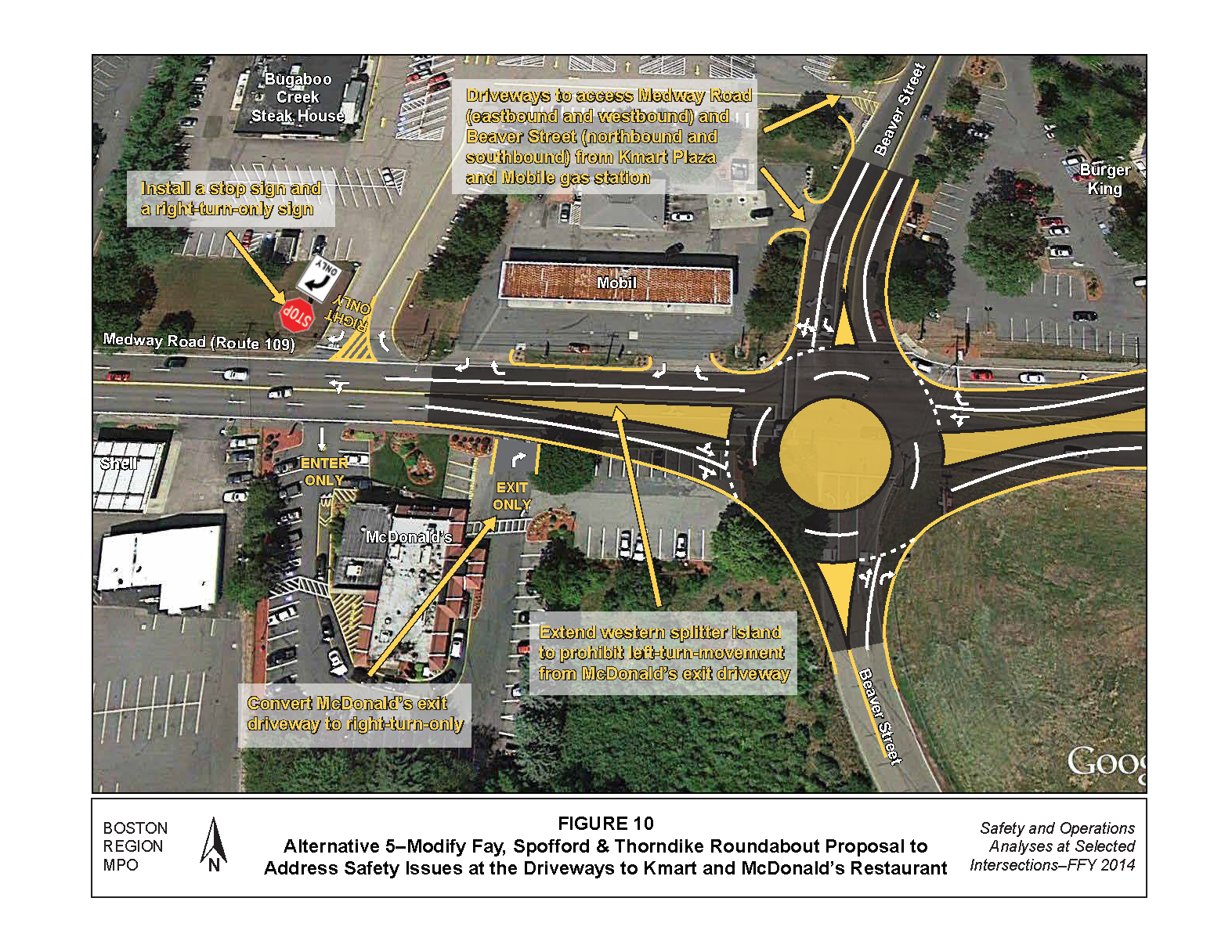
TABLE 7
Alternative 5: Future Year (2024) Peak-Hour Level of Service
Intersection / Approach |
Move-ment |
AM LOS |
AM Delaya |
AM Queueb |
PM LOS |
PM Delay |
PM Queue |
|---|---|---|---|---|---|---|---|
Medway Road at Beaver Street Roundabout |
-- |
-- |
-- |
-- |
-- |
-- |
-- |
Medway Road Eastbound |
L+T |
A |
8.1 |
25 |
D |
25.8 |
115 |
Medway Road Eastbound |
T+R |
A |
7.9 |
25 |
C |
25 |
115 |
Medway Road Westbound |
L+T |
B |
13.6 |
100 |
B |
10.5 |
50 |
Medway Road Westbound |
R |
B |
13.6 |
100 |
B |
10.4 |
50 |
Beaver Street Northbound |
L+T |
A |
7.1 |
25 |
D |
36.5 |
80 |
Beaver Street Northbound |
R |
A |
7.3 |
25 |
C |
34.4 |
80 |
Beaver Street Southbound |
L |
B |
10.4 |
25 |
B |
12.8 |
50 |
Beaver Street Southbound |
L+T+R |
A |
10 |
25 |
B |
12.5 |
50 |
Total Intersection |
All |
B |
11.5 |
-- |
C |
20 |
-- |
aDelay in seconds per vehicle. b 95th percentile queue length in feet. # = The 95th percentile volume exceeds capacity.
Source: Central Transportation Planning Staff.
MPO staff developed five alternatives to improve safety and access. Staff also evaluated the alternatives in terms of safety efficiency, congestion reduction, cost, and access to businesses. Cost and effectiveness are the two primary factors for selecting the preferred alternative. Alternatives 1 to 3 are short-term, low-cost solutions and they address many of the safety and access issues. Alternatives 4 and 5 are long-term, high-cost solutions—they address safety and access issues as well.
For the short-term alternatives, MPO staff recommends Alternative 2, as it provides turn lanes on Medway Road for safe access to businesses in the area. In addition, Alternative 2 provides the highest safety and operations benefits among the short-term alternatives. MassDOT Highway District 3 also supports Alternative 2. MPO staff does not recommend Alternative 1 because it reduces crashes only near the Kmart driveway, not at other driveways such as McDonald’s. Although Alternative 3 has safety benefits comparable to Alternative 2, staff does not recommend it because it limits access to some businesses such as McDonald’s.
For the long-term alternatives, MPO staff recommends Alternative 5 because it improves safety, traffic operations, and access to businesses on Medway Road. In addition, Alternative 5 supports Milford’s intention to convert Beaver Street south of the intersection to a two-way roadway in order to improve access to the Bear Hill Industrial Area and to develop land located south of the Medway Road and Beaver Street intersection. We do not recommend Alternative 4 because close proximity to the traffic signal at Medway Road and Beaver Street would create queue storage problems affecting traffic operations.
Alternative 2 is a cost-effective solution and can be implemented with minimal traffic disruption. In addition, Alternative 2 offers many of the benefits of Alternative 5. The reason why Alternative 5 is beneficial in the long term is that it improves access to the Bear Hill Industrial Area but Alternative 2 does not. In addition, Alternative 5 would facilitate economic development in the vicinity—this benefit would not be achieved with Alternative 2.
This study gives Milford an opportunity to begin looking at the needs of the intersection of Medway Road and driveways to Kmart and McDonald’s, and plan for design and engineering. The next steps after this planning study are:
Implementation of the long-term, high-cost improvement (Alternative 5) would require cooperation between MassDOT and Milford to begin the project notification and review process and preliminary design and engineering. MassDOT Highway Division’s project development process is included in Appendix F. Finally, the study supports MPO visions and goals, which include increasing transportation safety, preserving and maintaining the transportation system, reducing congestion, and advancing mobility.
SA/sa
cc: Joseph Frawley, MassDOT Highway Division, District 3
1 Seth Asante, memorandum to Boston Region MPO, Safety and Operations Analyses at Selected Intersections—FFY 2014, Task 1: Intersection Selection Procedure, December 19, 2013.
2 Transit Significance: Location carries bus route(s) or is adjacent to a transit stop or station.
3 Regional Significance: Location carries high proportion of regional traffic or noticeable commuter bicycle traffic
4 Implementation Potential: Location is under MassDOT jurisdiction, has a Transportation Improvement Program (TIP) “conceptual” status, or a strong commitment from a city or town.
5 Trafficware Inc., Synchro Studio 8, Synchro plus SimTraffic, Build 801, Version 563, Sugar Land, Texas.
6 Highway Capacity Manual, HCM 2010, Volume 3: Interrupted Flow, Transportation Research Board of the National Academies, Washington D.C., December 2010.
7 Crash Modification Factors Clearinghouse, US Department of Transportation, Federal Highway Administration, http://www.cmfclearinghouse.org/index.cfm.
8 Crash Modification Factors Clearinghouse, US Department of Transportation, Federal Highway Administration, http://www.cmfclearinghouse.org/index.cfm.
9 Crash Modification Factors Clearinghouse, U.S. Department of Transportation, Federal Highway Administration, http://www.cmfclearinghouse.org/index.cfm
10 Ibid
11 Sidra Intersection 6, Akcelik and Associates Pty Limited, Greythorn, Victoria, Australia.