CIVIL RIGHTS NOTICE TO THE PUBLIC Welcome. Bem Vinda. Bienvenido. Akeyi. 欢迎. 歡迎
You are invited to participate in our transportation planning process, free from discrimination. The Boston Region Metropolitan Planning Organization (MPO) is committed to nondiscrimination in all activities and complies with Title VI of the Civil Rights Act of 1964, which prohibits discrimination on the basis of race, color, or national origin (including limited English proficiency). Related federal and state nondiscrimination laws prohibit discrimination on the basis of age, sex, disability, and additional protected characteristics.
For additional information or to file a civil rights complaint, visit www.bostonmpo.org/mpo_non_discrimination.
To request this information in a different language or format, please contact:
Boston Region MPO Title IV Specialist 10 Park Plaza, Suite 2150 Boston, MA 02116 Phone: 857.702.3700 Email: civilrights@ctps.org
For people with hearing or speaking difficulties, connect through the state MassRelay service, www.mass.gov/massrelay. Please allow at least five business days for your request to be fulfilled. |
Abstract
The Boston Region Metropolitan Planning Organization’s (MPO) corridor studies are conducted through the Multimodal Mobility Infrastructure Program. The program aims to support a safe, accessible, and multimodal regional transportation system by addressing issues of safety, congestion, and multimodal mobility and accessibility. Staff to the MPO prioritized Route 114 in the City of Salem for study after considering several factors, including the need to address poor safety conditions and the desire to enhance multimodal transportation in that location. This report outlines the existing conditions, assesses safety and operational issues, proposes improvements, and identifies funding programs for implementing projects. The potential improvements, if implemented, would enhance safety, multimodal transportation service, and traffic operations, thereby supporting the residents, local businesses, and schools along the corridor.
ES.3 Existing Conditions and Needs Assessment
1.3 Corridor Selection Process
2.3 Norman and Washington Streets Segment
2.5.1 Walking and Biking Volumes
2.5.3 Bus and Commuter Rail Ridership
2.6.4 Bus Shelters and Benches
2.7.1 Historical Crash Summaries
2.7.2 High-Injury Network (HIN)
2.7.4 Vulnerable Road User (VRU) Crash Risk
2.7.7 Congestion, Delays, and Queues
2.9 Traffic Signal Warrants Analysis
Chapter 3—Proposed Improvements
3.3 Operational Impacts of Suggested Improvements
3.4 Safety Impacts of Suggested Improvements
Chapter 4—Conclusion and Next Steps
Table 1 Corridor Crash Summaries (2019–24)
Table 2 Intersection Level of Service Criteria
Table 3 Results of the Traffic Signal Warrant Analysis
Table 4 Potential Improvements on North Street Segment
Table 5 Potential Improvements on Norman and Washington Streets
Table 6 Potential Improvements on Lafayette Street
Table 7 Safety Benefits of Proposed Improvements
Figure 1 Corridor Study Locations
Figure 4 Peak Period Pedestrian Volumes
Figure 5 Peak Period Bicycle Volumes
Figure 6 Average Weekday Traffic Volumes
Figure 7 Peak Hour Turning Movement Volumes
Figure 8 Route 114 Crossing Locations and Types
Figure 10 Route 114 Bike Infrastructure
Figure 11 MBTA Transit Map, Salem
Figure 14 Intersection Crash Risk
Figure 15 Vulnerable Road User Crash Risk
Figure 16 Speeding on Route 114
Figure 17 2025 Weekday AM Peak Hour Delays and Level of Service
Figure 18 2025 Weekday PM Peak Hour Delays and Level of Service
Figure 19 Potential Improvements for North Street
Figure 20 Potential Improvements for Norman and Washington Streets
Figure 21 Potential Improvements for Lafayette Street
Figure 22 Safety Enhancements for Vulnerable Road Users
Figure 23 2040 Build: Weekday AM Peak Hour Delays and Level of Service
Figure 24 2040 Build: Weekday PM Peak Hour Delays and Level of Service
Appendix A: Advisory Task Force and Comments
Appendix B: Traffic and Speed Data
Appendix C: Traffic Safety Data
Appendix D: Intersection Level of Service Analysis and Signal Warrant Analysis
Appendix E: Community Survey Results
This study was conducted through the Boston Region Metropolitan Planning Organization’s (MPO) Multimodal Mobility Infrastructure Program (MMIP). The program aims to support a safe, accessible, and multimodal regional transportation system by addressing issues of safety, congestion, and multimodal mobility and accessibility. The program has three focus areas:
The MPO has committed to funding corridor studies over the past decade, demonstrating its long-term dedication to improving safety and multimodal transportation. Many of the recommendations from the corridor studies have been implemented, as they provide municipalities, the Massachusetts Department of Transportation (MassDOT), and stakeholders with the necessary information to address deficiencies in the corridors before committing to the design and engineering of projects.
The MPO staff selected Route 114 in the City of Salem as the subject of a corridor study in the federal fiscal year 2025. When evaluating locations for study, the Route 114 corridor scored highly among several corridors due to the high incidence of crashes involving vehicles and vulnerable road users (such as pedestrians, bicyclists, and people using mobility devices), operational problems such as speeding and congestion, and transportation modes along the corridor that require infrastructure upgrades.
Stakeholder participation was a crucial part of the study. MPO staff employed several methods to engage stakeholders, to gather local community perceptions regarding safety, operations, and infrastructure conditions, and to explore ideas for improvements. The engagement strategies included participatory mapping and a community survey that received 684 responses, gathering information about transportation concerns and ideas for improvement. Staff also attended several staff meetings at the City of Salem and three advisory committee meetings.
With the assistance of the City of Salem and MassDOT, MPO staff collected and assembled a wide range of data to assess existing conditions, launched a community survey to identify transportation concerns, and considered the results of safety analyses conducted through the MPO’s and the City of Salem’s Vision Zero programs. This process ensured that the recommendations were well-informed and that all relevant perspectives were considered.
Key concerns focus on safety and the high number of crashes involving vehicles and vulnerable road users that have occurred on the corridor, roadway segments where speeding has been an issue, poor infrastructure conditions, and infrastructure that is not compliant with the Americans with Disabilities Act (ADA). Other concerns include operational issues, such as congestion and queuing, and a lack of protection for users in bike lanes.
MPO staff developed short-, mid-, and long-term improvements to address the needs in the corridor. The short-term improvements are generally low-cost and relatively uncomplicated to implement. They would require minimal design efforts and typically take fewer than three years to complete. The mid-term improvements are medium cost, requiring minimal design efforts, and would take about three to five years to implement. The long-term improvements are generally costly, requiring more design and engineering efforts, and would typically take more than five years to implement.
The short-term improvements include implementing repairs to comply with ADA standards, enhancing intersection and crosswalk visibility, and improving signage and pavement markings. The mid-term improvements include adding retroreflective backplates to enhance the visibility of signals, upgrading signal equipment and features, and improving sidewalks. The long-term improvements include modernizing intersections and roadway segments to enhance safety and multimodal transportation, typically within a Complete Streets framework.
The recommendations developed in this study provide the City of Salem and stakeholders with an opportunity to review the potential improvements for addressing deficiencies before committing design and engineering funds to improvement projects in the corridor. The City of Salem could package recommendations included in this report into projects and then coordinate with the Boston Region MPO and MassDOT to identify funding sources for the projects. If implemented, the suggested improvements would enhance traffic safety and operations for all users.
The Boston Region Metropolitan Planning Organization (MPO) has been conducting studies of roadway corridors identified through the Multimodal Mobility Infrastructure Program as needing improvements to address issues of safety, congestion, and multimodal mobility and accessibility The studies aim to build consensus among stakeholders and engage them in planning for a safe, multimodal transportation system.
Study recommendations are sent to implementing agencies, which may fund projects through various federal, state, and local sources, either separately or in combination. Municipalities and the Massachusetts Department of Transportation (MassDOT) have been receptive to these studies, which offer an opportunity to review options for improving a specific corridor before allocating design and engineering funds. The study documentation can help project proponents complete MassDOT’s project initiation forms, justify the need for improvements, and facilitate the design and engineering process.
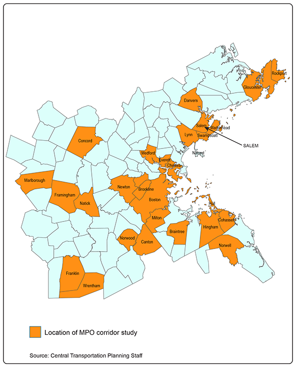
Many MPO-studied corridors have advanced into projects, are currently under construction, or have already been implemented. The map in Figure 1 shows the communities where corridor studies have occurred.
This report is organized into four chapters. Chapter 1 provides an overview of the Boston Region MPO’s corridor studies, including the selection process for choosing locations to study, goals and objectives, and community engagement efforts. Chapter 2 outlines the characteristics of Route 114 and the context of the study area, describes the data collection and existing condition assessments that informed the study, and discusses the need for improvements to infrastructure and operations. Chapter 3 outlines short-, mid-, and long-term improvements aligned with the corridor's transportation needs, along with their safety and operational advantages. Chapter 4 explains the project development and implementation process, including how to incorporate potential improvements into projects and secure funding to implement them.
The approach to MPO corridor studies starts with defining a universe of corridors. The MPO staff reach out to municipalities, subregional committees, and other stakeholders to identify corridors of concern. Staff also review the MPO’s Long-Range Transportation Planning (LRTP) Needs Assessment and the Congestion
Figure 1
Corridor Study Locations
Management Process, and consult the MassDOT Impact Portal and other tools to pinpoint corridors of interest. Once the universe of corridors is defined, staff screen the study locations using established criteria, such as the Transportation Improvement Program (TIP) scoring process. Corridors are then prioritized based on safety conditions, congestion levels, multimodal importance, regional significance, transportation equity, geographical distribution, and potential for implementation of projects. A corridor is then selected for study, considering feedback from agencies, municipalities, and stakeholders. After selecting a study location, an advisory committee is formed to guide the study, consisting of representatives from the municipality, MassDOT, business chambers of commerce, major employers, and educational institutions.
Following the above selection process, Route 114 in Salem was chosen for study in federal fiscal year 2025. The study location was selected from a list of 43 arterial segments across 33 municipalities in the Boston Region MPO area. The City of Salem, MassDOT, and Salem State University (SSU) supported the study by gathering the necessary data for the analyses and reviewing the study documents.
The MPO committed to studying Route 114 in Salem to address safety and operational concerns. The high rate of crashes involving vehicles, pedestrians, and bicyclists, operational problems such as speeding, congestion, and poor infrastructure have been impacting users. Therefore, the goals and objectives of the study focused on improving conditions for users by increasing safety and upgrading infrastructure for walking, biking, driving, and transit.
Stakeholder participation is a crucial element of any MPO-sponsored study. An advisory committee comprising staff from the City of Salem, MassDOT, the Massachusetts Bay Transportation Authority (MBTA), the Saltonstall School, and SSU was formed to guide the project. MPO staff convened the advisory committee to launch the study. During the kickoff meeting, staff outlined the purpose and needs, scope of work, tasks, deliverables, and timeline. In subsequent meetings, staff presented the existing conditions and survey results, highlighted corridor needs and potential improvements, and collected feedback. Staff also launched an interactive mapping survey to assess public opinions on transportation issues and gather ideas for solutions. This report incorporates the advisory committee’s feedback. Appendix A provides a list of advisory committee members and their review comments.
Salem is a well-established suburban community located 16 miles north of Boston with approximately 45,000 residents and a diverse business sector. Salem’s multimodal transportation system offers public transit options connecting to nearby communities and Boston. Commuter rail service is available at the MBTA’s Salem Station on the Newburyport/Rockport Line, and there are five local and express bus routes, as well as a seasonal ferry service to Boston. For transportation planning purposes, the City of Salem is a member of the Metropolitan Area Planning Council’s North Shore Task Force.
Figure 2 illustrates the study area along with nearby communities and streets.
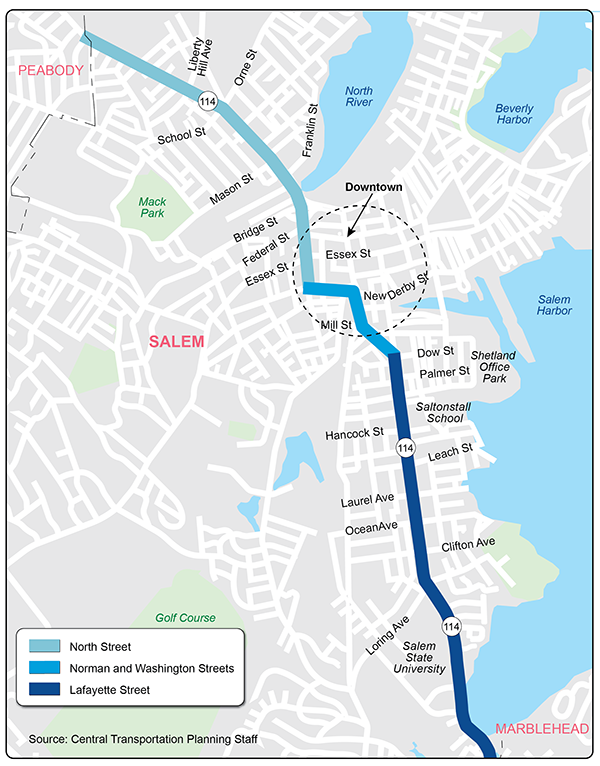
The study corridor is a three-mile segment of Route 114, stretching from the Peabody city line to the Marblehead town line. This two-lane, two-way roadway widens to include turn lanes at signalized intersections and is open to all traffic, including trucks, serving both regional and local travelers. In the northern part, the roadway is called North Street and Summer Street; in the middle, Norman Street and Washington Street; and in the south, Lafayette Street. Figure 3 illustrates these segments.
The character and context of the roadway change along these segments of the corridor, as it accommodates multiple modes of transportation (walking, biking, driving, and transit) and provides access to areas with diverse land uses (residential, educational, recreational, and commercial). It is bordered by dense residential and commercial development. Residents in the area include a significant low-income and minority population, including people with limited English proficiency. The roadway directly connects to SSU, Saltonstall School, Salem Station, and downtown Salem.
This section of Route 114 is primarily a city-owned principal arterial that is part of the National Highway System, thus highway projects on it are eligible for federal and state funding. The Massachusetts Department of Transportation (MassDOT) owns the section with the North Street Bridge overpass and the section of North Street that goes over the North River culvert.
The northern part of the corridor is surrounded by dense residential areas and a mix of commercial and recreational spaces near the downtown area. This segment has the highest traffic volume in the corridor. Approximately 28,000 vehicles travel the corridor daily between Federal and Mason Streets, making direct connections to Route 107, the MBTA station, downtown, and Peabody. There are continuous sidewalks and bike lanes on both sides of the corridor.
Figure 2
Study Area
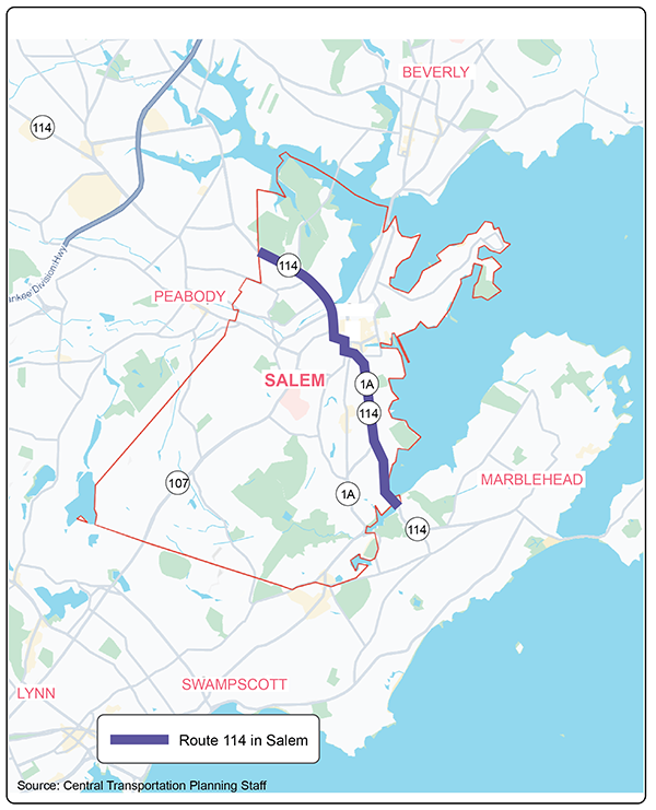
Figure 3
Route 114 Segments
This segment has four signalized intersections at School Street, Mason Street, Federal Street, and Essex Street. An emergency traffic signal has been installed at the fire station near Dearborn Street. All crosswalks across North Street are marked, and pedestrian-activated signals control those with traffic signals. Dedicated pedestrian signals are present at the crosswalks near the intersections of Liberty Hill Avenue and Oakland Street, and rectangular rapid flashing beacons (RRFBs) are installed for the crosswalks near the intersections of Dearborn Street and Cressy Avenue.
MBTA bus Route 435 operates along this segment.
The middle section of the corridor is surrounded by a mix of residential, commercial, and institutional buildings and developments in the downtown area. Approximately 15,000 vehicles travel daily on Norman Street, while approximately 30,000 vehicles use the busiest part of Washington Street, primarily due to its proximity to the MBTA station and downtown area.
Both sides of the roadway in this segment have continuous sidewalks and bike lanes, along with crosswalks marked and managed by pedestrian-activated signals, RRFBs, or pedestrian signs. There are two signalized intersections—at New Derby Street and Mill Street/Canal Street—and a mini roundabout at Norman and Summer Streets.
MBTA bus Routes 451 and 455 run along a portion of this segment.
A mix of residential and educational buildings surround the southern part of the corridor. This segment carries approximately 14,000 to 18,000 vehicles daily. Sidewalks and bike lanes are on both sides of the roadway.
This segment has two signalized intersections, located at Dow Street and Loring Avenue, as well as two pedestrian signals, one at Leach Street and another at Ocean Avenue. All crosswalks across Lafayette Street are marked and controlled by pedestrian-activated signals, RRFBs, or pedestrian crossing signs.
MBTA bus Route 455 runs through part of this segment.
A comprehensive data collection plan was developed, encompassing the gathering of data from existing databases maintained by the City of Salem, MassDOT, MBTA, and the MPO for analysis. The data included relevant information about roadway users (people walking, biking, driving, and using transit), infrastructure conditions (sidewalks, crosswalks, traffic signals, streetlights, and parking), and operations (crashes, speeds, delays, and queues).
MassDOT collected data on traffic volumes, vehicle speeds, and the mix of vehicles, pedestrians, and bicyclists using the corridor. Daily traffic volumes were measured continuously at 24 sites over three consecutive days, from Tuesday, March 25 to Friday, March 28, 2025. Intersection turning movement counts (TMCs) were recorded at 16 intersections on Tuesday, March 25, 2025, including counts of pedestrians, bicycles, and trucks. The TMC counts were conducted during the weekday morning peak (6:00 AM to 9:00 AM) and afternoon peak (3:00 PM to 6:00 PM). The traffic and speed data are included in Appendix B.
Figures 4 and 5 display pedestrian and bicycle volumes at selected intersections during peak travel times. Pedestrian volumes at the intersections ranged from 93 to 672, with the highest numbers near downtown on North Street, Washington Street, and Lafayette Street. Bicycle volumes during the same period ranged from 14 to 43, with the highest recorded on Washington Street. These volumes could be higher at other times of the year, as the counts were taken during a period of cold weather in March.
Figure 6 displays the average daily traffic volumes on segments of Route 114 and on selected side streets. The average daily traffic on the corridor ranged from 14,000 to 28,000 vehicles per day. The highest traffic volumes were recorded on the four-lane stretch of North Street between Federal and Mason Streets. The lowest volumes were recorded on the segment near the town line of Marblehead. Figure 7 shows the turning-movement volumes at the 16 intersections during weekday morning and afternoon peak travel hours. The volumes of pedestrians observed at each intersection during the peak periods are also shown.
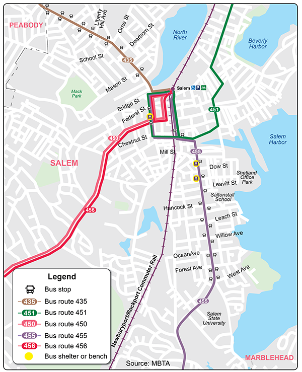
Information from 2023 on transit ridership and operating service performance was obtained from the MBTA. The average number of weekday boardings at all bus stops in Salem for the five MBTA bus routes (Routes 435, 450, 451, 455, and 456) that run along portions of Route 114, is 1,242 riders. For the commuter rail, the average is 2,326 riders.
Figure 4
Peak Period Pedestrian Volumes
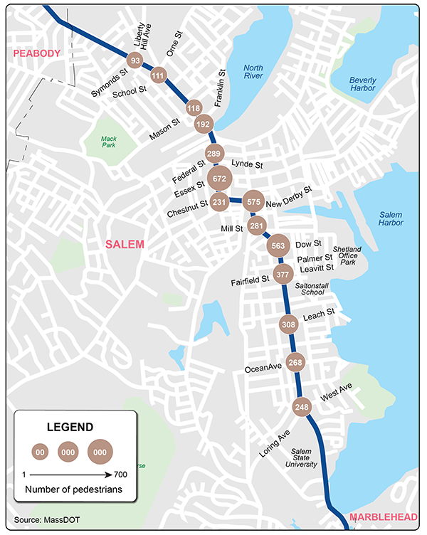
Figure 5
Peak Period Bicycle Volumes
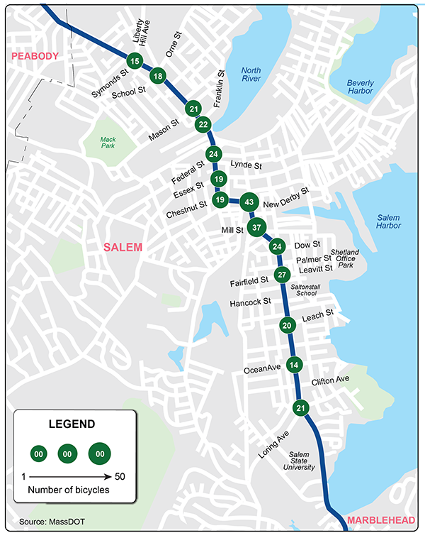
Figure 6
Average Weekday Traffic Volumes
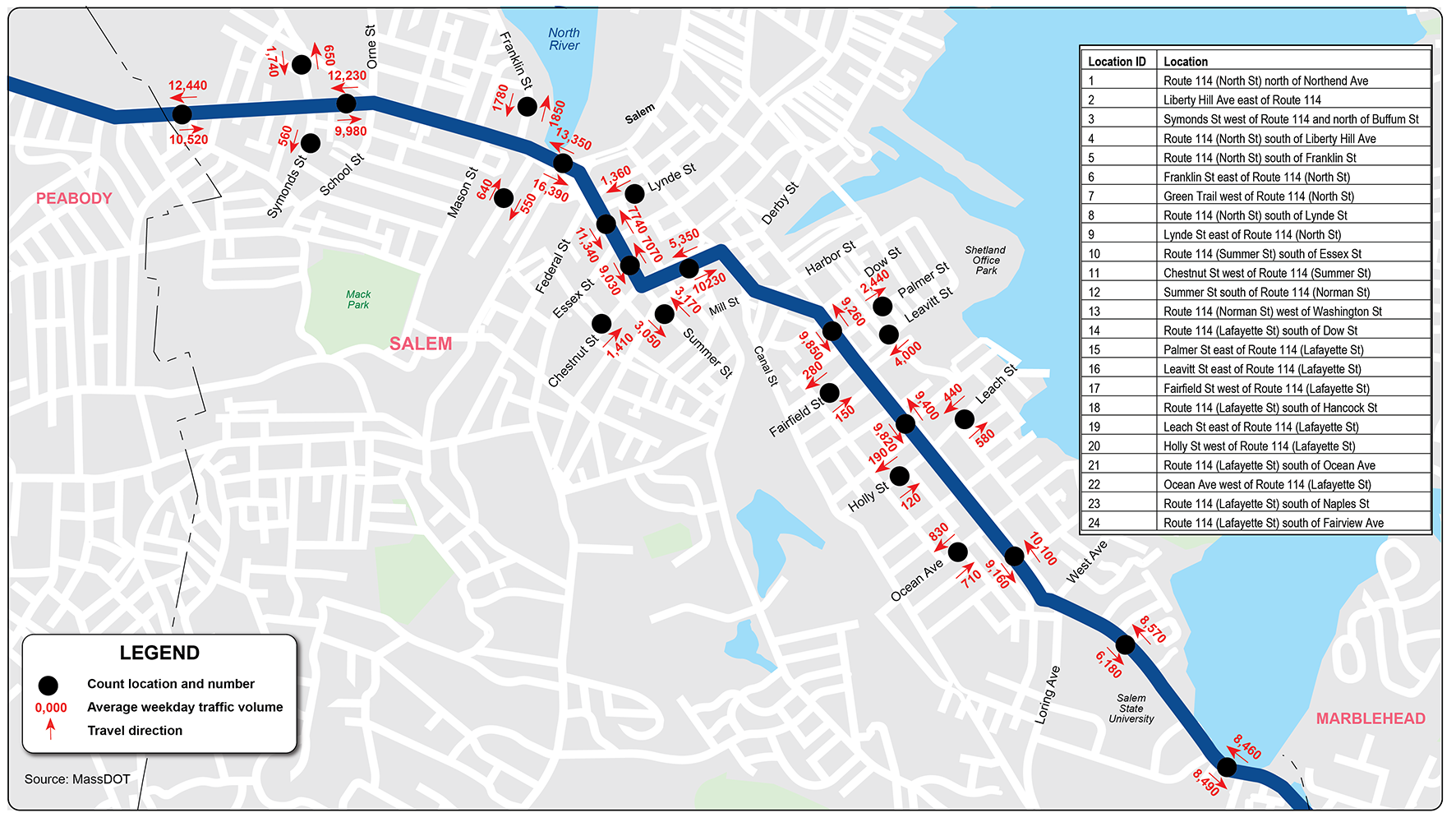
Figure 7
Peak Hour Turning Movement Volumes
Pedestrians can safely cross Route 114 at several locations in the study area. Figure 8 displays the locations and types of crosswalks along the roadway. There are 30 marked crosswalks across Route 114, averaging one every 550 feet. Most of these locations are accessible and meet ADA standards, though some on Lafayette Street do not comply.
The following signals and signage exist at the crossing locations:
Figure 9 shows the locations and conditions of the sidewalks. More than 95 percent of the roadway has sidewalks on both sides, and most are in good or fair condition. They require repairs to meet the ADA standards.
The sections in poor condition are on Lafayette Street near the Marblehead town line. The poor sidewalk conditions create challenges for people walking and those using mobility devices.
The corridor features bike lanes that are approximately five feet wide for approximately 90 percent of its length. Figure 10 shows the types of bike lanes in the corridor: parking-protected, buffered, unbuffered (unprotected), and shared-use. Approximately 60 percent of the bike lanes lack buffer protection, and there are several short segments where people biking share the roadway with vehicles. These conditions create high stress and safety concerns for people biking due to the high speeds and volumes of vehicles.
Figure 11 displays the bus routes in Salem, along with the locations of the stops on Route 114. Analysis of 2023 ridership data showed that three bus stops on Route 114 are suitable for installing a shelter and a bench:
Two of the eligible stops already have shelters, and one has only a bench because it did not pass the site suitability test.
Figure 8
Route 114 Crossing Locations and Types
Figure 9
Sidewalk Condition
Figure 10
Route 114 Bike Infrastructure
Figure 11
MBTA Transit Map, Salem
Most of the traffic signals on Route 114 are in good condition. However, several require upgrades, such as backplates, yellow retroreflective borders, larger lenses (12 inches), and accessible features to enhance safety and visibility. Traffic signal equipment at these intersections is outdated and needs to be upgraded:
A comprehensive assessment of the traffic signals on Route 114 is necessary to determine if they can adapt and respond dynamically to changing conditions and be interconnected to coordinate multiple signals.
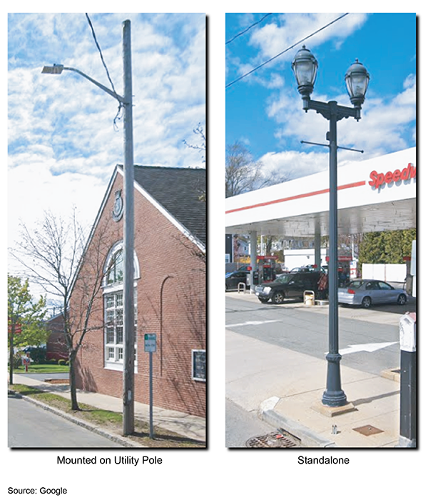
There are two types of streetlights in the corridor: those mounted on utility poles and standalone lights. Examples are shown in Figure 12. The streetlights are in good condition, spaced approximately 90 to 120 feet apart, and mounted at heights from 20 to 30 feet. However, nearly 30 percent of the crashes in the corridor happen in dark conditions, during nighttime, dusk, or dawn.
Figure 12
Streetlights
Crash data from January 2019 through September 2024 was analyzed for trends. The analysis, which is summarized in Table 1, shows the following:
Table 1
Corridor Crash Summaries (2019–24)
Crash Variable |
Number of Crashes |
Percent |
Total number of crashes |
933 |
100 |
Severity |
-- |
-- |
Property damage only |
675 |
72 |
Nonfatal injury |
217 |
23 |
Fatality |
0 |
0 |
Not reported/unknown |
41 |
5 |
Crash Type |
-- |
-- |
Single vehicle |
57 |
6 |
Rear-end |
338 |
36 |
Angle |
320 |
34 |
Head-on |
84 |
9 |
Sideswipe, same direction |
105 |
11 |
Sideswipe, opposite direction |
18 |
2 |
Not reported/unknown |
11 |
2 |
Ambient Light Conditions |
-- |
-- |
Daylight |
662 |
71 |
Dark—lighted roadway |
228 |
24 |
Dark—roadway not lighted |
8 |
1 |
Dark—unknown |
2 |
0 |
Dawn |
7 |
1 |
Dusk |
25 |
3 |
Unknown/other |
1 |
0 |
Involved pedestrian(s) |
46 |
5 |
Involved bicyclist(s) |
23 |
2.5 |
Wet or icy pavement conditions |
148 |
16 |
Dark conditions (lighted or not lighted) |
236 |
29 |
Source: Central Transportation Planning Staff.
The Route 114 safety assessment references Salem and MPO Vision Zero initiatives. Route 114 is part of Salem's high-injury network (HIN), making it a key corridor for safety improvements. The HIN highlights corridors with fatal and serious injury crashes, as shown in Figure 13.
Figure 14 shows the key intersections along the corridor where crashes and the risk of crashes is highest. These locations were identified by using both a crash-based and risk-based analysis. The reactive crash-based method focuses on historical crash severity-weighted frequency as a leading safety indicator. In contrast, the proactive risk-based method considers roadway and community features as primary factors that contribute to increased risk of injury. Both methods are essential for developing effective and proactive safety strategies.
Figure 13
High-Injury Network
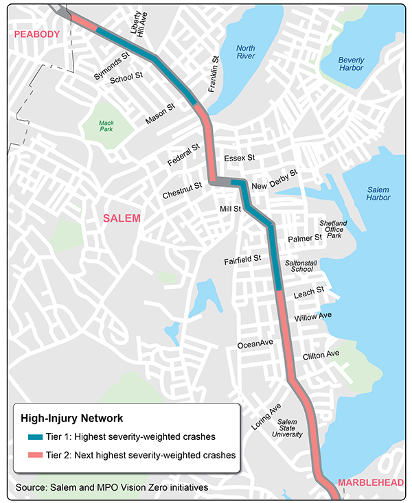
Figure 14
Intersection Crash Risk
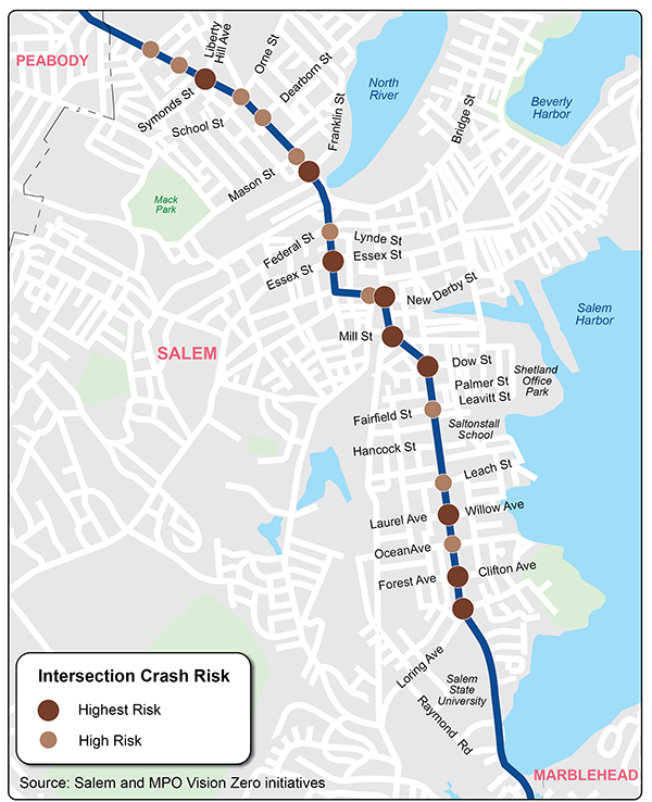
Figure 15 shows the locations along the corridor where crashes and the risk of crashes is highest for vulnerable road users (such as pedestrians, bicyclists, and people using mobility devices). These locations also were identified by using both a crash-based and risk-based analysis. Shown are sites where actual crashes occurred involving pedestrians and bicyclists, and areas of high risk for these users.
MPO staff prepared collision diagrams for most of the roadway segments, including major intersections, using crash data from 2019 to 2024. These diagrams enable the identification of patterns and factors contributing to crashes, as well as the identification of effective safety strategies. The diagrams and reference tables presenting the characteristics of the crashes are included in Appendix C.
The following findings are consistent with the summaries in collision diagrams:
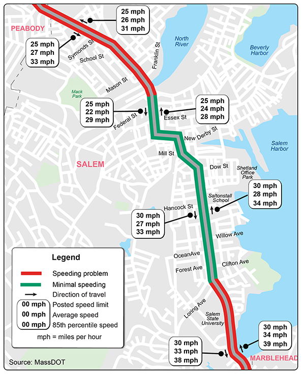
MassDOT conducted speed studies at four locations along Route 114, and the findings are summarized in Figure 16. The sections of Route 114 with speeding issues are North Street, west of Federal Street, and Lafayette Street, south of Loring Avenue. In these areas, the 85th percentile speeds are 7 to 10 miles per hour (mph) above the speed limit. The speed data are included in Appendix B.
Figure 15
Vulnerable Road User Crash Risk
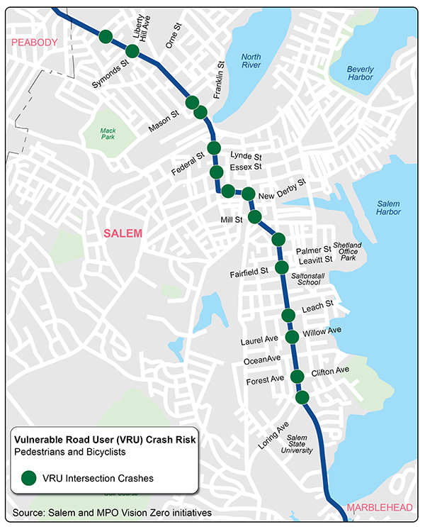
Figure 16
Speeding on Route 114
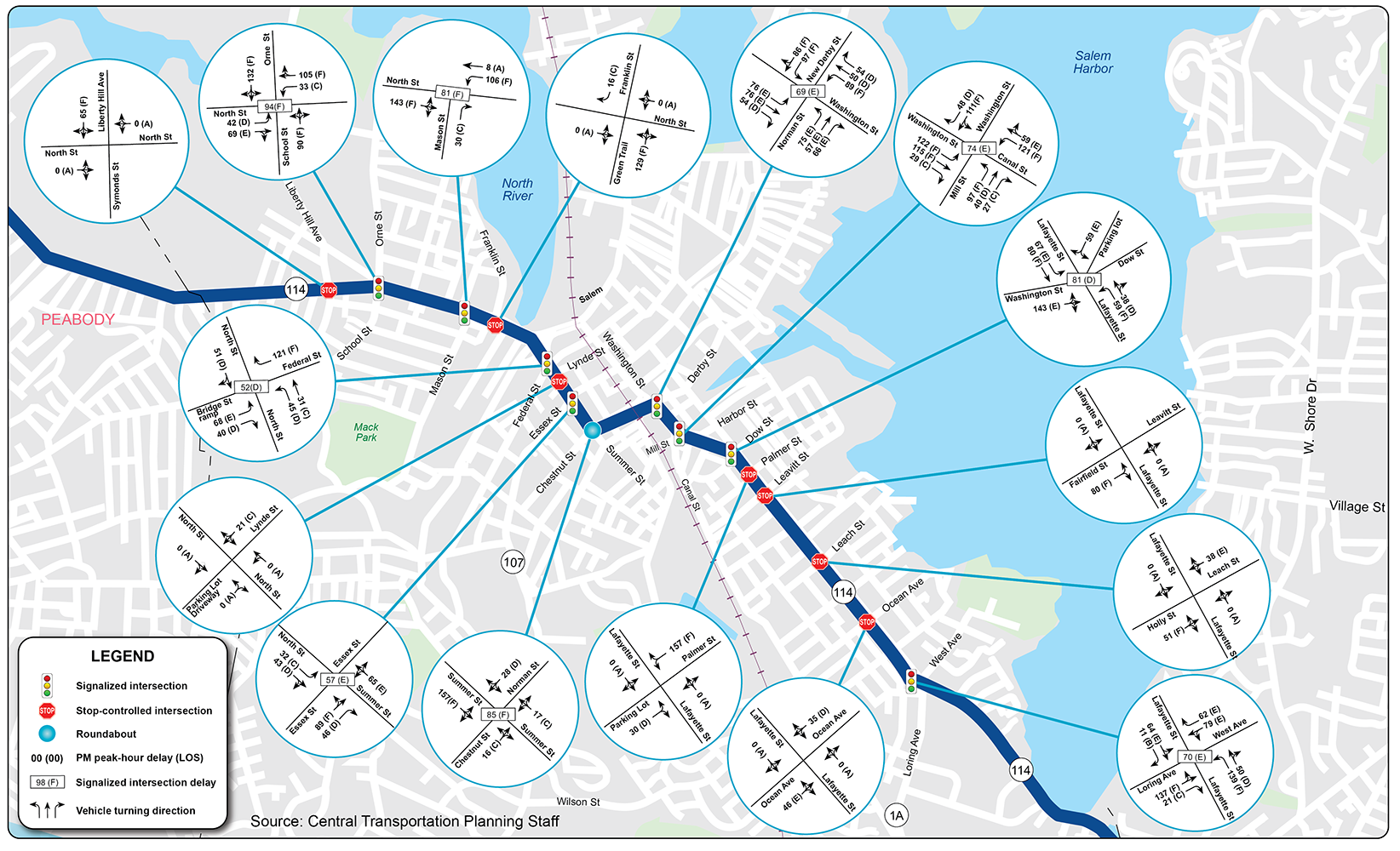
MPO staff conducted traffic-operations analyses using Synchro 12 to assess traffic conditions at signalized and unsignalized intersections.1 Table 2 presents the delays and levels of service (LOS) for signalized and unsignalized intersections. LOS A represents the best operating conditions (little to no delay). In contrast, LOS F represents the worst operating conditions (long delay). LOS E represents operating conditions at capacity (the limit of acceptable delay). The intersection LOS analyses are included in Appendix D.
Table 2
Intersection Level of Service Criteria
| Level of Service |
Signalized Intersection |
Unsignalized Intersection Control Delay |
|---|---|---|
A |
<10 |
<10 |
B |
10–20 |
10–15 |
C |
20–35 |
15–25 |
D |
35–55 |
25–35 |
E |
55–80 |
35–50 |
F |
>80 |
>50 |
Source: Transportation Research Board, Highway Capacity Manual, Seventh Edition, 2022.
Figures 17 and 18 show the LOS and delays at the signalized and unsignalized intersections during weekday morning and afternoon peak hours. Eight signalized intersections were found to operate under congested conditions with LOS E or F, resulting in queuing at multiple locations during peak travel hours. Several unsignalized intersections also were found to experience significant delays on side streets during peak travel periods. Traffic on the side streets at these intersections also were operating at LOS E or F, with queuing on their approaches.
Figure 11 shows the MBTA service in or near the study area, including commuter rail and five bus routes. Commuter rail service to Boston runs every 30 minutes on weekdays and every 60 minutes on weekends. All five bus routes serving Salem start at the commuter rail station. The MBTA’s Bus Network Redesign plan, approved in 2022 for implementation over five years, proposes the following changes:
Figure 17
2025 Weekday AM Peak Hour Delays and Level of Service
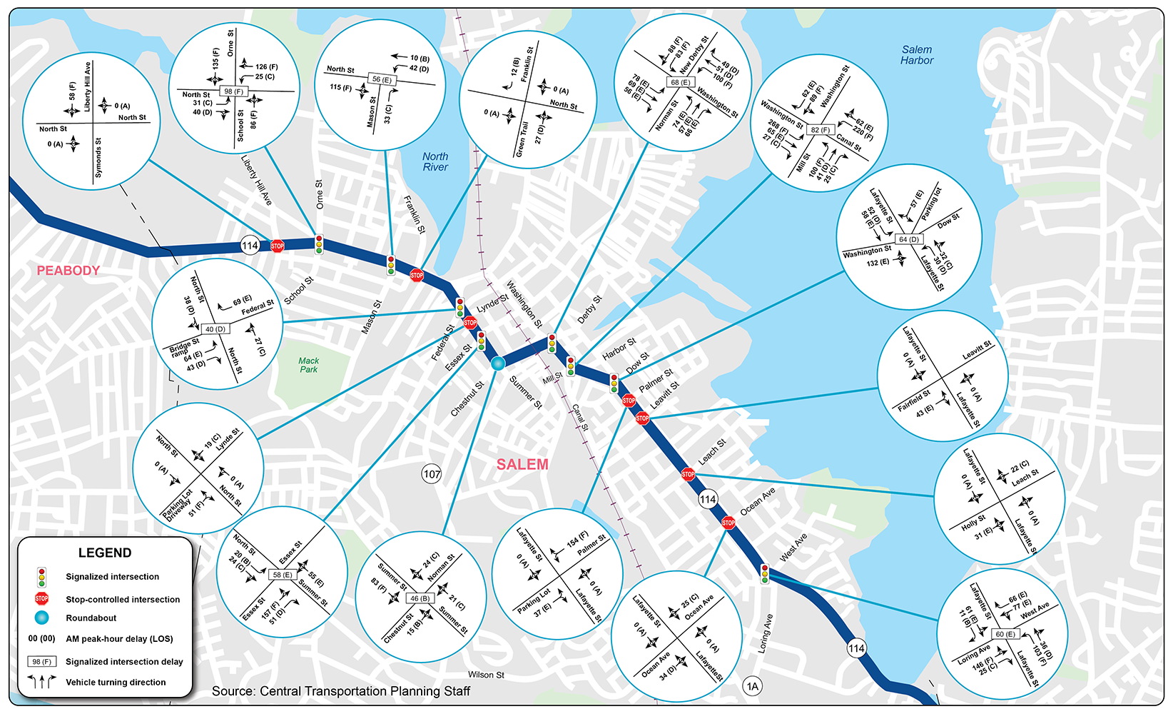
Figure 18
2025 Weekday PM Peak Hour Delays and Level of Service
Justifying the need for a traffic control signal at an unsignalized intersection involves analyzing factors related to current traffic flow and safety conditions, as well as the potential for improvement. The Manual on Uniform Traffic Control Devices (MUTCD) lists nine traffic signal warrants that support installing a signal. Table 3 displays these nine warrants and the analysis results for intersections with significant side street delays. Installing signals may be justified at some of these locations, and this should be investigated further. Detailed traffic signal warrant analysis worksheets are included in Appendix D.
Table 3
Results of the Traffic Signal Warrant Analysis
Warrant |
Liberty Hill Avenue |
Franklin Street |
Lynde Street |
Norman Street Circle |
Palmer Street |
Warrant 1, Eight-Hour Vehicular Volume |
Satisfied |
Satisfied |
Satisfied |
Satisfied |
Satisfied |
Warrant 2, Four-Hour Vehicular Volume |
Satisfied |
Satisfied |
Satisfied |
Satisfied |
Satisfied |
Warrant 3, Peak Hour
|
Satisfied |
Satisfied |
Satisfied |
Satisfied |
Satisfied |
Warrant 4, Pedestrian Volume |
Not satisfied |
Not satisfied |
Not satisfied |
Not satisfied |
Not satisfied |
Warrant 5, School Crossing |
Not satisfied |
Not satisfied |
Not satisfied |
Not satisfied |
Not satisfied |
Warrant 6, Coordinated Signal System |
Satisfied |
Not satisfied |
Not satisfied |
Not satisfied |
Not satisfied |
Warrant 7, Crash Experience |
Not satisfied |
Not satisfied |
Not satisfied |
Not satisfied |
Not satisfied |
Warrant 8, Roadway Network |
Satisfied |
Satisfied |
Satisfied |
Satisfied |
Satisfied |
Warrant 9, Intersection Near a Grade Crossing |
Not satisfied |
Not satisfied |
Not satisfied |
Not satisfied |
Not satisfied |
Source: Central Transportation Planning Staff.
Staff created an interactive mapping survey to gather the community’s opinions on transportation issues related to walking, biking, transit, driving, parking, and other concerns along the corridor, as well as potential solutions. The survey questionnaire, responses, and specific comments are included in Appendix E. Respondents had the option to participate in the survey in English, Spanish, Portuguese, and Haitian Kreyol. The survey was shared with the City of Salem for promotion on city websites and social media platforms and for distribution to residents and stakeholders. The survey was launched in mid-June and closed on July 30, 2025, after gathering 684 responses.
The following information was gleaned from the survey:
The corridor, in its current state, has deficiencies that impact user safety, mobility, quality of life, and access to businesses and other sites for residents. The challenges, which relate to the corridor's role in providing safe and efficient multimodal transportation, emphasize the urgent need to improve safety and operations, promote multimodal transportation, and upgrade the infrastructure, including the following:
Chapter 3—Proposed Improvements
Recently completed, ongoing, and planned projects for the corridor include the following:
The corridor was divided into three segments based on context: North Street, Norman and Washington Streets, and Lafayette Street. For each segment, staff developed recommendations for improvements for both the segment and specific intersections along it. The improvements were categorized by time frame and cost. The time frames are defined as follows: short-term improvements are typically expected to be completed within three years, mid-term improvements within three to five years, and long-term improvements in more than five years. In terms of cost, low-cost improvements are those under $10,000, medium-cost improvements are between $10,000 and $50,000, and high-cost improvements exceed $50,000.
Most short-term improvements usually do not require design and engineering efforts. These improvements include installing new signs, upgrading old signs, marking pavement, painting high-visibility crosswalks, and upgrading curb ramps to ADA standards. Some mid-term improvements may require some design and engineering efforts. These improvements include protecting existing bike lanes, installing rectangular rapid flashing beacons (RRFBs) and pedestrian signals, and repairing substandard sidewalks. The long-term improvements require significant design and engineering efforts, as well as larger funding sources. They include safety, multimodal, and operational improvements, such as intersection and roadway reconstruction in a Complete Streets framework.
Tables 4 through 6 present the proposed improvements, including the time and cost categories and jurisdictional responsibilities. Figures 19 through 21 illustrate graphically some of the improvements in the segment. Figure 22 gives examples of successful strategies to enhance safety for vulnerable road users.
Table 4
Potential Improvements on North Street Segment
| Table 4 Potential Improvements on North Street | |||||
| Issue/Concern | Safety Category | Suggested Improvement | Time Frame | Cost | Responsibility |
| 1—North Street Segment | |||||
| The segment is part of a high-injury network, and several intersections along the segment are primary angle crash sites. | Traffic Signal Operations and Visibility | Consider enhancing safety through traffic calming, signal optimization, lighting, and intersection improvements, such as making the recent traffic-calming and speed management improvements on North Street permanent. | Long | High | City of Salem |
| Drivers fail to yield to pedestrians crossing streets. | Pedestrian and Bicycle Accommodation | Evaluate and implement leading pedestrian intervals for the signalized intersections with concurrent pedestrian and vehicle phases. | Short | Medium | City of Salem |
| Drivers fail to yield to pedestrians crossing streets. | Pedestrian and Bicycle Accommodation | Consider installing rectangular rapid flashing beacons at the uncontrolled marked crosswalks on North Street. | Short | Medium | City of Salem |
| Pedestrians have to wait too long for the Walk signal. | Pedestrian and Bicycle Accommodation | Optimize signal timings, including pedestrian timing and clearance intervals, to minimize pedestrian delay and prevent illegal crossings. | Short | Low | City of Salem |
| Crashes are more likely to occur in dark conditions. | Intersection Visibility | Evaluate and improve street and pedestrian-scale lighting to reduce crashes in dark and low-light conditions. | Short | Low | City of Salem |
| Crashes are more likely to occur in dark conditions. | Traffic Signal Operations and Visibility | Consider installing backplates with retroreflective borders on all signal heads to improve signal visibility. | Short | Medium | City of Salem |
| Drivers tend to speed on North Street. | Roadway Features | Install speed limit signs and speed feedback signs at regular intervals to inform drivers of speed limits. | Short | Low | City of Salem |
| Drivers tend to speed on North Street. | Roadway Features | Consider making the recent traffic-calming and speed management improvements on North Street permanent. | Long | High | City of Salem |
| Drivers run red lights, risking pedestrian safety. | Traffic Signal Operations and Visibility | Assess clearance intervals and update them to current standards as needed to enhance safety and operational efficiency. | Short | Low | City of Salem |
| Drivers encounter congestion, delays, and long queues in the segment. | Traffic Signal Operations and Visibility | Upgrade the signal equipment to incorporate technologies that can adapt and respond dynamically to changing conditions. | Long | High | City of Salem |
| Drivers encounter congestion, delays, and long queues in the segment. | Traffic Signal Operations and Visibility | Optimize signal timings and phasing, and coordinate signals within a 1,500-foot distance to enhance traffic flow. | Short | Medium | City of Salem |
| Bike lanes between Franklin Street and Essex Street have gaps and lack protection. | Pedestrian and Bicycle Accommodation | Assess the feasibility of installing flex posts or curbing to prevent drivers from encroaching on or raising the bike lanes and integrating them with the sidewalks. | Middle | Medium | City of Salem |
| 2—Liberty Hill Avenue at North Street | |||||
| Intersection is a primary angle crash site. | Traffic Operations and Visibility | Consider installing a traffic signal to improve safety. | Long | High | City of Salem |
| Crashes occur more often in dark conditions. | Intersection Visibility | Evaluate and improve street and pedestrian-level lighting. | Short | Low | City of Salem |
| Drivers have to wait too long to turn out of Liberty Hill Avenue. | Pavement Markings and Signage | Consider installing pavement markings and signage to improve traffic operations. | Short | Low | City of Salem |
| Drivers have to wait too long to turn out of Liberty Hill Avenue. | Traffic Signal Operations and Visibility | Consider installing a traffic signal to reduce delays. | Long | High | City of Salem |
| 3—School Street/Orne Street at North Street | |||||
| Drivers often fail to yield to pedestrians crossing streets. | Pedestrian and Bike Accommodation | Consider implementing leading pedestrian intervals (LPI) during concurrent vehicle and pedestrian phases. | Short | Medium | City of Salem |
| Drivers often fail to yield to pedestrians crossing streets. | Pedestrian and Bike Accommodation | Evaluate and update No Right Turn on Red signage placement to ensure it is MUTCD compliant. | Short | Low | City of Salem |
| Drivers encounter congestion, delays, and long queues. | Traffic Signal Operations and Visibility | Optimize signal timings and phasing and coordinate signals within 1,500 feet of each other to enhance traffic flow. Coordinate signals at School Street and Mason Street as a subsystem. | Short | Medium | City of Salem |
| Drivers encounter congestion, delays, and long queues. | Traffic Signal Operations and Visibility | Consider implementing a protected or permissive phase for eastbound and westbound left turns on North Street during peak hours. | Short | Medium | City of Salem |
| Drivers encounter congestion, delays, and long queues. | Traffic Signal Operations and Visibility | Upgrade the signal equipment to incorporate technologies that can adapt and respond dynamically to changing conditions. | Long | High | City of Salem |
| Drivers run red lights, risking pedestrian safety. | Traffic Signal Operations and Visibility | Evaluate clearance intervals and update them to meet current safety and operational standards. | Short | Low | City of Salem |
| 4—Mason Street at North Street | |||||
| Vulnerable road users face high risks at intersections, especially where the crosswalk is missing on the west side of North Street. | Pedestrian and Bike Accommodation | Consider adding a crosswalk on the west side of North Street. | Short | Low | City of Salem |
| Drivers encounter congestion, delays, and long queues. | Traffic Signal Operations and Visibility | Optimize signal timings and phasing and coordinate signals within 1,500 feet of each other to enhance traffic flow. Coordinate signals at Mason Street and School Street as a subsystem. | Short | Medium | City of Salem |
| Drivers encounter congestion, delays, and long queues. | Traffic Signal Operations and Visibility | Upgrade the signal equipment to integrate technologies that can adapt and respond dynamically to changing conditions, thereby optimizing flow and reducing congestion. | Long | High | City of Salem |
| Drivers are using the Citgo driveways to turn left onto North Street, which is not permitted on Mason Street, creating safety concerns. | Traffic Signal Operations and Visibility | Consider adding signs to reinforce the prohibition or enforcement to prevent such maneuvers. | Short | Low | City of Salem |
| Drivers are using the Citgo driveways to turn left onto North Street, which is not permitted on Mason Street, creating safety concerns. | Traffic Signal Operations and Visibility | Assess the feasibility of allowing left turns on Mason Street. | Short | Low | City of Salem |
| Drivers run red lights, risking pedestrian safety. | Traffic Signal Operations and Visibility | Review clearance intervals and revise them to current standards as necessary to enhance safety and operational efficiency. | Short | Low | City of Salem |
| 5—Franklin Street at North Street | |||||
| There is no crosswalk on North Street at the intersection. | Pedestrian and Bike Accommodation | Consider adding a crosswalk with pedestrian-activated signals on North Street. | Middle | High | City of Salem |
| Drivers exiting the Speedway gas station are involved in many crashes. | Intersection Geometry and Operations | Assess the feasibility of signalizing the intersection to enable left turns and pedestrian crossing. | Long | High | City of Salem |
| Drivers have to wait too long to turn out of Franklin Street. | Traffic Signal Operations and Safety | Assess the feasibility of signalizing the intersection to enable left turns and pedestrian crossing. | Long | High | City of Salem |
| 6—On-ramp at North Street Bridge over Route 107 | |||||
| Drivers tend to speed on the ramp. | Pavement Markings and Signage | Install speed limit signs, speed feedback signs, and pavement markings to raise awareness. | Short | Low | MassDOT and City of Salem |
| Crashes occur more often in dark conditions. | Intersection Visibility | Evaluate and improve street and pedestrian-scale lighting to reduce crashes in dark and low-light conditions. | Short | Low | MassDOT and City of Salem |
| Drivers treat the ramp like a highway on-ramp and fail to yield to pedestrians. | Pedestrian and Bike Accommodation | Consider installing a rectangular rapid flashing beacon at the crosswalk on the on-ramp to enhance pedestrian safety. | Short | Medium | MassDOT and City of Salem |
| Drivers treat the ramp like a highway on-ramp and fail to yield to pedestrians. | Pedestrian and Bike Accommodation | Alternatively, consider replacing the yield sign with a stop sign and adding pedestrian crossing signs. | Short | Low | MassDOT and City of Salem |
| 7—Federal Street/Ramp at North Street | |||||
| Drivers often do not yield to pedestrians crossing the street. | Pedestrian and Bike Accommodation | Evaluate and update No Right Turn on Red signage placement to ensure it is MUTCD compliant and improve pedestrian safety. | Short | Low | MassDOT and City of Salem |
| Drivers often do not yield to pedestrians crossing the street. | Pedestrian and Bike Accommodation | Assess the feasibility of eliminating the eastbound right-turn slip lane from the ramp onto southbound North Street due to low volumes on the on-ramp. Will shorten a proposed crosswalk on the west side of North Street described below. | Short | Medium | MassDOT and City of Salem |
| Drivers often do not yield to pedestrians crossing the street. | Pedestrian and Bike Accommodation | Consider installing a crosswalk on the west side (southbound) of North Street across the ramp to improve pedestrian safety. | Short | Medium | MassDOT and City of Salem |
| Pedestrians are trying to access the MBTA station. | Pedestrian and Bike Accommodation | Install wayfinding signs to direct pedestrians and bicyclists on safe routes to the MBTA station. | Short | Low | MassDOT and City of Salem |
| Drivers run red lights and yield signs, risking pedestrian safety. | Traffic Signal Operations and Visibility | Assess clearance intervals and revise them to meet current standards and operational requirements. | Short | Low | MassDOT and City of Salem |
| Drivers are not given advance notice of lane assignments and often become confused, resulting in them ending up in the wrong lane. | Pavement Markings and Signage | Consider installing signs and pavement markings in advance to guide drivers into the correct lanes on North Street between Federal Street and Essex Street. | Short | Low | MassDOT and City of Salem |
| Drivers face congestion, delays, and long queues, and pedestrians have to wait too long for the Walk signal. | Traffic Signal Operations and Visibility | Optimize signal timings and phasing and coordinate signals within 1,500 feet of each other to enhance traffic flow. Coordinate signals at Federal Street and Essex Street as a subsystem. | Short | Medium | MassDOT and City of Salem |
| Signal equipment is outdated. | Traffic Signal Operations and Visibility | Upgrade the signal equipment to incorporate technologies that can adapt and respond dynamically to changing conditions, thereby optimizing flow and reducing congestion | Long | High | MassDOT and City of Salem |
| 8—Lynde Street at North Street | |||||
| Drivers turning left out of Lynde Street are often involved in crashes. | Traffic Signal Operations and Visibility | Consider prohibiting left turns from Lynde Street (and allowing right turns only). | Short | Low | City of Salem |
| Drivers turning left out of Lynde Street are often involved in crashes. | Traffic Signal Operations and Visibility | Assess the practicality of reversing traffic flow on Lynde Street. | Middle | Medium | City of Salem |
| Drivers turning left out of Lynde Street are often involved in crashes. | Intersection Geometry and Operations | Evaluate the feasibility of reconstructing the intersection to improve safety. | Long | High | City of Salem |
| Drivers have to wait too long to turn out of Lynde Street. | Traffic Signal Operations and Visibility | Evaluate the feasibility of installing a signal at the intersection to decrease delays on Lynde Street. | Long | High | City of Salem |
| 9—Essex Street at North Street | |||||
| Vulnerable road users are at high risk, as drivers often fail to yield to pedestrians. | Pedestrian and Bicycle Accommodation | Remove the right-turn slip lane from Essex Street to Summer Street to enhance pedestrian safety. | Short | Medium | City of Salem |
| Crashes often occur under dark conditions. | Intersection Visibility | Evaluate and enhance street and pedestrian-scale lighting to reduce crashes during dark and low-light conditions. | Short | Low | City of Salem |
| Sidewalks are narrow and need improvement. | Pedestrian and Bicycle Accommodation | Assess and improve sidewalks. | Middle | Medium | City of Salem |
| Drivers run red lights, risking pedestrian safety. | Traffic Signal Operations and Visibility | Assess clearance intervals and update them to current standards as necessary to enhance safety and operational efficiency. | Short | Low | City of Salem |
| Drivers encounter congestion, delays, and long queues, and pedestrians have to wait too long for the Walk signal. | Traffic Signal Operations and Visibility | Optimize signal timings and phasing and coordinate signals within 1,500 feet of each other to enhance traffic flow. Coordinate signals at Federal Street and Essex Street as a subsystem. | Short | Medium | City of Salem |
| Drivers encounter congestion, delays, and long queues. | Traffic Signal Operations and Visibility | Upgrade the signal equipment to incorporate technologies that can adapt and respond dynamically to changing conditions, thereby optimizing flow and reducing congestion. | Long | High | City of Salem |
| Drivers often become confused about lane assignments on the southbound approach to North Street and end up in the wrong lane. | Pavement Markings and Signage | Consider installing signs and pavement markings in advance to guide drivers into the correct lanes. | Short | Low | City of Salem |
| 10—Chestnut Street/Norman Street at Summer Street | |||||
| Drivers often do not yield to pedestrians crossing streets. | Pedestrian and Bike Accommodation | Consider adding a rectangular rapid flashing beacon to the crosswalks to increase driver yield rates. | Short | Medium | City of Salem |
| The roundabout is malfunctioning during the peak travel period, resulting in congestion, delays, and lengthy queues for drivers. | Intersection Geometry | Evaluate the feasibility of replacing the roundabout with a traffic signal or two-way stop sign control to enhance safety and traffic flow. | Long | High` | City of Salem |
| MUTCD = Manual on Uniform Traffic Control Devices. |
* Leading Pedestrian Intervals (LPI) is used to establish pedestrian presence in the crosswalk before providing green ball indications for drivers.
Table 5
Potential Improvements on Norman and Washington Streets
| Table 5 Potential Improvements on Norman and Washington Streets | |||||
| Issue/Concern | Safety Category | Suggested Improvement | Time Frame | Cost | Responsibility |
| 11—Norman and Washington Streets Segment | |||||
| The segment is part of a high-injury network, and two intersections on the segment are primary angle crash sites. | Traffic Signal Operations and Visibility | Consider enhancing safety with traffic calming, signal optimization, lighting, and intersection improvements. | Long | High | City of Salem |
| Bike lanes are absent on Washington Street from Mill Street to Lafayette Street. | Pedestrian and Bicycle Accommodation | Consider adding shared-lane markings or signs to alert drivers of the presence of bicyclists. | Short | Low | City of Salem |
| Drivers often become confused about lane assignments and end up in the wrong lane. | Traffic Signal Operations and Visibility | Consider installing signs and pavement markings (including white dotted lines at intersections) in advance to guide drivers into the correct lanes at intersections. | Short | Low | City of Salem |
| Crashes are more likely to occur in dark conditions. | Intersection Visibility | Evaluate and improve street and pedestrian-scale lighting to increase visibility and reduce crashes during dark and low-light conditions. | Short | Low | City of Salem |
| Crashes are more likely to occur in dark conditions. | Traffic Signal Operations and Visibility | Consider installing backplates with retroreflective borders on all signal heads to improve signal visibility. | Short | Medium | City of Salem |
| Drivers tend to speed on Washington Street. | Roadway Features | Install speed limit and speed feedback signs at regular intervals to raise awareness. | Short | Low | City of Salem |
| 12—Norman Street/New Derby Street at Washington Street | |||||
| Intersection is a primary angle crash site. | Traffic Signal Operations and Visibility | Review clearance intervals and update them to current standards as needed to enhance safety and operational efficiency. | Short | Low | City of Salem |
| Intersection is a primary angle crash site. | Traffic Signal Operations and Visibility | Consider a Road Safety Audit for the intersection. | Short | Low | City of Salem |
| Drivers often fail to yield to pedestrians crossing streets. | Pedestrian and Bicycle Accommodation | Consider prohibiting right turns on red after stopping on Norman Street to increase pedestrian safety. | Short | Low | City of Salem |
| Drivers often fail to yield to pedestrians crossing streets. | Pedestrian and Bicycle Accommodation | Evaluate and update the placement of No Right Turn on Red signage to ensure it is MUTCD compliant. | Short | Low | City of Salem |
| Pedestrians have to cross too many lanes. | Pedestrian and Bicycle Accommodation | Assess the feasibility of incorporating curb extensions to decrease crossing distance and tightening curb radii to prevent speeding. | Short | Medium | City of Salem |
| Crashes are more likely to occur in dark conditions. | Traffic Signal Operations and Visibility | Evaluate and enhance street and pedestrian-scale lighting to improve visibility and decrease crashes in dark and low-light conditions. | Short | Low | City of Salem |
| Crashes are more likely to occur in dark conditions. | Traffic Signal Operations and Visibility | Consider installing backplates with retroreflective borders on all signal heads to improve signal visibility. | Short | Medium | City of Salem |
| Drivers often run red lights, risking the safety of pedestrians. | Traffic Signal Operations and Visibility | Evaluate clearance intervals and update them to current standards as needed to enhance safety and operational efficiency. | Short | Low | City of Salem |
| Drivers encounter congestion and pedestrians wait too long for the Walk signal to change. | Traffic Signal Operations and Visibility | Optimize signal timings and phasing and coordinate signals within 1,500 feet of each other to enhance traffic flow and pedestrian safety. | Short | Medium | City of Salem |
| Drivers encounter congestion, delays, and long queues. | Traffic Signal Operations and Visibility | Upgrade the signal equipment to incorporate technologies that can adapt and respond dynamically to changing conditions, thereby optimizing traffic flow and reducing congestion. | Long | High | City of Salem |
| Drivers often become confused about lane assignments on the North Street southbound approach and end up in the wrong lane. | Pavement Markings and Signage | Consider installing signs and pavement markings (including dotted white lines in the intersection) in advance to guide drivers into the correct lanes. | Short | Low | City of Salem |
| Drivers get into crashes due to the lane drop and merge on Washington Street just north of New Derby Street. | Pavement Markings and Signage | Consider installing pavement markings in addition to existing signage to enhance safety at the merge area. | Short | Low | City of Salem |
| 13—Mill Street/Canal Street at Washington Street | |||||
| Intersection is a primary angle crash site. | Traffic Signal Operations and Visibility | Review clearance intervals and update them to current standards as needed to enhance safety and operational efficiency. | Short | Low | City of Salem |
| Intersection is a primary angle crash site. | Traffic Signal Operations and Visibility | Consider a Road Safety Audit for the intersection. | Short | Low | City of Salem |
| Drivers often fail to yield to pedestrians crossing streets. | Pedestrian and Bicycle Accommodation | Evaluate and update the placement of No Turn on Red signage to ensure it is MUTCD compliant. | Short | Low | City of Salem |
| The bike lane on the west side (southbound) of Washington Street ends before reaching Mill Street. | Pedestrian and Bicycle Accommodation | Assess whether removing the exclusive right-turn lane on southbound Washington Street is feasible, due to the low volume of right turns, and consider implementing a shared through/right turn lane. | Short | Medium | City of Salem |
| The bike lane on the west side of Washington Street ends before reaching Mill Street. | Pedestrian and Bicycle Accommodation | If a shared through/right-turn lane is installed, consider extending the bike lane on the west side of Washington Street to Mill Street. | Short | Medium | City of Salem |
| The bike lane ends on the west side of Washington Street before the approach at Mill Street. | Pedestrian and Bicycle Accommodation | An alternative to the above recommendation is to consider narrowing lanes on the southbound approach of Washington Street at Mill Street to accommodate a bike lane. | Middle | Medium | City of Salem |
| Pedestrians have to cross too many lanes. | Pedestrian and Bicycle Accommodation | Assess the feasibility of incorporating curb extensions to shorten crossing distances and tightening curb radii to slow down vehicles. | Short | Medium | City of Salem |
| Crashes are more likely to occur in dark conditions. | Traffic Signal Operations and Visibility | Assess street and pedestrian-scale lighting to increase visibility and reduce crashes during dark and low-light conditions. | Short | Low | City of Salem |
| Drivers encounter congestion and pedestrians wait too long for the walk signal to change. | Traffic Signal Operations and Visibility | Optimize signal timings and phasing and coordinate signals within 1,500 feet of each other to enhance traffic flow and pedestrian safety. | Short | Medium | City of Salem |
| Drivers encounter congestion, delays, and long queues. | Traffic Signal Operations and Visibility | Review and upgrade the signal equipment to incorporate technologies that can adapt and respond flexibly to changing conditions, thereby optimizing flow and reducing congestion. | Long | High | City of Salem |
| Drivers often run red lights, risking the safety of pedestrians. | Traffic Signal Operations and Visibility | Review clearance intervals and revise them to meet current standards, enhancing safety and traffic flow. | Short | Low | City of Salem |
| Drivers frequently get confused about lane assignments on the approaches and often end up in the wrong lane. | Pavement Markings and Signage | Consider installing signs and pavement markings (including dotted white lines in the intersection) in advance to guide drivers into the correct lanes. | Short | Low | City of Salem |
| 14—Ropes Street at Washington Street | |||||
| Drivers often fail to yield to pedestrians. | Pedestrian and Bicycle Accommodation | Consider installing pedestrian crossing signs for the crosswalk on Washington Street near Ropes Street. | Short | Low | City of Salem |
| MUTCD = Manual on Uniform Traffic Control Devices. |
Table 6
Potential Improvements on Lafayette Street
| Table 6 Potential Improvements on Lafayette Street | |||||
| Issue/Concern | Safety Category | Suggested Improvement | Time Frame | Cost | Responsibility |
| 15—Lafayette Street Segment | |||||
| The segment is part of a high-injury network, and several intersections along the segment are primary angle crash sites. | Traffic Signal Operations and Visibility | Consider enhancing safety with traffic calming, signal optimization, lighting, and intersection improvements. | Long | High | City of Salem |
| Drivers often fail to yield to pedestrians crossing streets. | Pedestrian and Bike Accommodation | Consider daylighting intersections, installing curb extensions, or adding a rectangular rapid flashing beacon to enhance visibility and signal to drivers to yield. | Short | Medium | City of Salem |
| Drivers park too close to intersections, which limits sight distance. | Pedestrian and Bike Accommodation | Consider removing parking near crosswalks to enhance visibility by installing curb extensions or daylighting intersections. | Middle | Medium | City of Salem |
| Bike lane markings are fading and becoming hard to see. | Pedestrian and Bike Accommodation | Repaint bike lane markings and extend the markings through intersections to improve visibility. | Short | Low | City of Salem |
| Bike lanes are unprotected, and drivers frequently use them to pass other vehicles. | Pedestrian and Bike Accommodation | Consider establishing parking-protected bike lanes on Lafayette Street. | Middle | High | City of Salem |
| Bike lanes are unprotected, and drivers frequently use them to pass other vehicles. | Pedestrian and Bike Accommodation | Consider raising the bike lanes and connecting them to the sidewalk to enhance safety. | Long | High | City of Salem |
| Sidewalks are in poor condition or need repairs. | Pedestrian and Bike Accommodation | Repair or reconstruct sidewalks and curb ramps to comply with ADA standards. | Middle | Medium | City of Salem |
| Crashes are more likely to occur in dark conditions. | Intersection Visibility | Evaluate and adjust street and pedestrian-scale lighting to increase visibility. | Short | Low | City of Salem |
| Drivers often speed on Lafayette Street, especially south of Loring Avenue. | Roadway Features | Install speed limit signs and speed feedback signs at regular intervals. | Short | Low | City of Salem |
| Drivers often speed on Lafayette Street, especially south of Loring Avenue. | Roadway Features | Consider implementing the traffic calming and speed management improvements on Lafayette Street. | Long | High | City of Salem |
| Drivers run red lights, risking pedestrian safety. | Traffic Signal Operations and Visibility | Assess clearance intervals and update to current standards as necessary to enhance safety. | Short | Low | City of Salem |
| Drivers encounter congestion, delays, and long queues in the segment. | Traffic Signal Operations and Visibility | Optimize signal timings and phasing to enhance traffic flow. | Short | Medium | City of Salem |
| Drivers encounter congestion, delays, and long queues in the segment. | Traffic Signal Operations and Visibility | Upgrade the signal equipment to incorporate technologies that can adapt and respond dynamically to changing conditions. | Long | High | City of Salem |
| Drivers encounter delays on the side streets. | Pavement Marking and Signage | Add pavement markings and signage to help traffic turning out of the side streets or consider installing traffic signals at intersections that meet signal warrants. | Short | Low | City of Salem |
| The surface of the road is in poor condition and not well maintained. | Maintenance | Assess and provide routine maintenance or resurface Lafayette Street. | Middle | Medium | City of Salem |
| Transit service is infrequent. | Transit | Coordinate with the MBTA to ensure that frequent and express bus service is available on Lafayette Street. | Short | Medium | City of Salem |
| 16—Washington Street, Dow Street at Lafayette Street | |||||
| The intersection is a primary site for angle crashes. | Traffic Signal Operations and Visibility | Assess clearance intervals and update them to current standards as needed to enhance safety and operations. | Short | Low | City of Salem |
| The intersection is a primary site for angle crashes. | Traffic Signal Operations and Visibility | Consider a Road Safety Audit for this intersection and the intersections of Palmer and Leavitt Streets. | Short | Low | City of Salem |
| Drivers park too close to the intersection, which limits sight distance. | Pedestrian and Bike Accommodation | Consider daylighting intersections by removing parking near crosswalks or installing curb extensions to enhance visibility. | Short | Medium | City of Salem |
| Vulnerable road users are at high risk. (Drivers make right turns on red after stopping on Washington Street, which is unsafe.) | Pedestrian and Bike Accommodation | Consider prohibiting right turns on red after stopping on Washington Street to Lafayette Street southbound. | Short | Low | City of Salem |
| Vulnerable road users are at high risk, especially when drivers make illegal left turns onto Dow Street from Washington Street. | Pedestrian and Bike Accommodation | Consider installing No Left Turn signs (both overhead and post-mounted) to alert drivers on Washington Street not to turn left onto Dow Street. | Short | Low | City of Salem |
| Drivers often fail to yield to pedestrians in crosswalks. | Pedestrian and Bike Accommodation | Evaluate and update the placement of No Turn On Red signage to ensure it complies with the MUTCD. | Short | Low | City of Salem |
| Pavement markings are fading and becoming difficult to see, especially at the intersections. | Pedestrian and Bike Accommodation | Repaint bike lane markings through the intersection to improve visibility and enhance safety for bicyclists. | Short | Low | City of Salem |
| Drivers run red lights, risking pedestrian safety. | Traffic Signal Operations and Visibility | Assess clearance intervals and revise them to meet current safety and efficiency standards. | Short | Low | City of Salem |
| Crashes are more likely to occur in dark conditions. | Intersection Visibility | Evaluate and adjust street and pedestrian-scale lighting to increase visibility. | Short | Low | City of Salem |
| Crashes are more likely to occur in dark conditions. | Intersection Visibility | Consider installing backplates with retroreflective borders on all signal heads to improve signal visibility. | Short | Low | City of Salem |
| Drivers encounter congestion and delays, and pedestrians have to wait too long for the Walk signal to appear. | Traffic Signal Operations and Visibility | Evaluate signal phasing and timing, and consider making improvements to reduce queues and congestion. | Short | Medium | City of Salem |
| Drivers encounter congestion, delays, and long queues. | Traffic Signal Operations and Visibility | Assess and upgrade the signal equipment to incorporate technologies that can adapt and respond dynamically to changing conditions. | Long | High | City of Salem |
| Drivers encounter congestion, delays, and long queues. | Traffic Signal Operations and Visibility | Evaluate whether implementing a one-way flow around Lafayette Park and reversing some existing one-way directions could help improve safety and traffic flow, or enhance bike safety. | Long | High | City of Salem |
| 17—Palmer Street at Lafayette Street | |||||
| The intersection is a primary site for angle crashes. | Traffic Signal Operations and Visibility | Install a traffic signal at the intersection to enhance pedestrian safety and traffic flow. | Long | High | City of Salem |
| Drivers often fail to yield to pedestrians in crosswalks. | Pedestrian and Bike Accommodation | Consider installing rectangular rapid flashing beacons on the uncontrolled marked crosswalk on Lafayette Street to improve pedestrian safety. | Short | Medium | City of Salem |
| Crashes are more likely to occur in dark conditions. | Intersection Visibility | Evaluate and adjust street and pedestrian-scale lighting to enhance visibility. | Short | Low | City of Salem |
| Drivers have to wait too long to turn out of Palmer Street. | Traffic Signal Operations and Visibility | Consider installing a traffic signal to improve traffic flow. | Long | High | City of Salem |
| Drivers have to wait too long to turn out of Palmer Street. | Traffic Signal Operations and Visibility | Consider reversing traffic directions on Leavitt Street and installing a traffic signal at the Leavitt Street intersection to improve traffic flow. This option provides more space between the signal at the intersection of Dow and Washington Streets for queue build-up. | Long | High | City of Salem |
| 18—Leavitt Street at Lafayette Street | |||||
| Drivers often fail to yield to pedestrians in crosswalks. | Pedestrian and Bicycle Accommodation | Consider installing rectangular rapid flashing beacon at the uncontrolled marked crosswalk on Lafayette Street to improve pedestrian safety. | Middle | Medium | City of Salem |
| Drivers often fail to yield to pedestrians in crosswalks. | Traffic Signal Operations and Visibility | Consider reversing traffic directions on Palmer Street and installing a traffic signal at the Leavitt Street intersection to improve traffic flow. This option provides more space between the signal at the intersection of Dow and Washington Streets for queue build-up. | Long | High | City of Salem |
| Vulnerable road users are at high risk as drivers park close to intersections, which limits sight distance. | Pedestrian and Bike Accommodation | Consider daylighting the intersection or installing curb extensions by removing parking near crosswalks. | Short | Medium | City of Salem |
| 19—Saltonstall/Hancock Street at Lafayette Street | |||||
| Drivers often fail to yield to pedestrians in crosswalks. | Pedestrian and Bicycle Accommodation | Consider installing rectangular rapid flashing beacons at the uncontrolled marked crosswalks on Lafayette Street near Hancock Street/Saltonstall Parkway. | Middle | Medium | City of Salem |
| Drivers park too close to the intersection, which limits sight distance. | Pedestrian and Bike Accommodation | Consider daylighting the intersection by removing parking near crosswalks or installing curb extensions to improve visibility. | Short | Medium | City of Salem |
| Crashes occur more often in dark conditions. | Intersection Visibility | Assess and enhance street and pedestrian-level lighting to improve visibility and reduce crashes in dark and low-light conditions. | Short | Low | City of Salem |
| There is congestion during school drop-off and pick-up times. | Pavement Markings and Signage | Consider using pavement markings and signage to prevent double parking, parking in bike lanes, and parking near crosswalks. | Short | Low | City of Salem |
| 20—Leach Street/Holly Street at Lafayette Street | |||||
| Drivers often fail to yield to pedestrians crossing streets. | Pedestrian and Bike Accommodation | Consider upgrading the pedestrian signal equipment to comply with current MassDOT standards. | Long | High | City of Salem |
| Drivers become confused by the blinking green light and the simultaneous yellow and red lights. | Pedestrian and Bike Accommodation | Consider updating the flashing green, simultaneous yellow, and red signal indications as needed to comply with MassDOT standards. | Middle | Medium | City of Salem |
| The pedestrian signal equipment is outdated. | Traffic Signal Operations and Visibility | Upgrade the pedestrian signal equipment as necessary to comply with current MassDOT standards. | Long | High | City of Salem |
| Drivers have to wait too long to turn out of the side streets. | Traffic Signal Operations and Visibility | Assess and upgrade the pedestrian signal to full traffic signals to manage traffic on side streets, speeding, and system coordination. Ocean Avenue has more traffic than Leach Street; however, Leach Street is in a more central position. | Long | High | City of Salem |
| Drivers often park too close to intersections, which reduces sight distance and endangers pedestrian safety. | Pedestrian and Bike Accommodation | Consider daylighting the intersection or installing curb extensions to increase pedestrian visibility. | Middle | Medium | City of Salem |
| Pavement markings are fading and becoming increasingly difficult to see, especially at intersections. | Pedestrian and Bike Accommodation | Repaint bike lane and crosswalk markings to improve safety for bicyclists. | Short | Low | City of Salem |
| Crashes are more likely to occur in dark conditions. | Intersection Visibility | Evaluate and improve street and pedestrian-level lighting to increase visibility. | Short | Low | City of Salem |
| 21—Laurel Street/Willow Avenue at Lafayette Street | |||||
| Drivers often fail to yield to pedestrians crossing streets. | Pedestrian and Bike Accommodation | Consider installing pedestrian crossing signs at the uncontrolled marked crosswalk on Lafayette Street to enhance pedestrian safety. | Middle | Medium | City of Salem |
| Drivers park too close to the intersection, which limits sight distance. | Pedestrian and Bike Accommodation | Consider daylighting the intersection by removing parking near the crosswalk or installing curb extensions to enhance visibility. | Short | Medium | City of Salem |
| Drivers have to wait too long to turn out of the side streets. | Pavement Marking and Signage | Assess and install pavement markings and signage to assist traffic turning onto the side streets. | Short | Low | City of Salem |
| 22 Ocean Avenue at Lafayette Street | |||||
| Intersection is a primary angle crash site. | Traffic Signal Operations and Visibility | Assess and upgrade the pedestrian signal to full traffic signals to manage traffic on side streets, speeding, and system coordination. | Long | High | City of Salem |
| Drivers often fail to yield to pedestrians crossing streets. | Pedestrian and Bike Accommodation | Consider upgrading the pedestrian signal equipment to meet current MassDOT standards. | Long | High | City of Salem |
| Drivers become confused by the blinking green light and the simultaneous yellow and red lights. | Pedestrian and Bike Accommodation | Consider updating the flashing green, simultaneous yellow, and red signal indications as necessary to comply with current MassDOT standards. | Middle | Medium | City of Salem |
| Drivers park close to the intersection, which limits sight distance. | Pedestrian and Bike Accommodation | Consider installing curb extensions or daylighting the intersection to enhance pedestrian visibility. | Middle | Medium | City of Salem |
| Crashes are more likely to occur in dark conditions. | Intersection Visibility | Evaluate and improve street and pedestrian-level lighting to increase visibility. | Short | Low | City of Salem |
| Drivers have to wait too long to turn out of the side streets. | Traffic Signal Operations and Visibility | Upgrade the pedestrian signal to a full traffic signal to better control traffic on side streets, speeding, and system coordination. Ocean Avenue has more traffic than Leach Street; however, Leach Street is in a more central position. | Long | High | City of Salem |
| The pedestrian signal equipment is outdated. | Traffic Signal Operations and Visibility | Upgrade the pedestrian signal equipment as necessary to comply with current MassDOT standards. | Long | High | City of Salem |
| 23—Forest Avenue/Clifton Avenue at Lafayette Street | |||||
| The intersection is a primary angle crash site. | Intersection Visibility | Consider installing curb extensions or daylighting the intersection by removing parking to enhance visibility and increase safety for pedestrians and drivers. | Short | Medium | City of Salem |
| Drivers often fail to yield to pedestrians crossing streets. | Pedestrian and Bike Accommodation | Consider adding pedestrian crossing signs to the uncontrolled marked crosswalk on Lafayette Street. | Middle | Medium | City of Salem |
| Drivers have to wait too long to turn out of the side streets. | Pavement Marking and Signage | Evaluate and install pavement markings and signage to assist traffic in turning out of the side streets. | Short | Low | City of Salem |
| Traffic queues frequently extend into the intersection, creating safety problems for pedestrians and drivers. | Traffic Signal Operations and Visibility | Assess and optimize signal timing and phasing sequence at the intersection of Lafayette Street and Loring Avenue to decrease queues. | Short | Medium | City of Salem |
| 24—Loring Avenue/West Avenue at Lafayette Street | |||||
| Drivers run red lights, risking pedestrian safety. | Traffic Signal Operations and Visibility | Assess clearance intervals and update them to comply with current standards. | Short | Low | City of Salem |
| The right-turn lane on Lafayette Street is too short for the amount of traffic it carries. | Intersection Geometry | Assess and consider lengthening the southbound right-turn lane on Lafayette Street to accommodate current traffic demands. | Short | Low | City of Salem |
| Vulnerable road users are at high risk at intersections. | Pedestrian and Bike Accommodation | Evaluate and update No Turn On Red signs to improve pedestrian safety at the intersection. | Short | Low | City of Salem |
| Drivers encounter congestion and delays, and pedestrians have to wait too long for the Walk signal. | Traffic Signal Operations and Visibility | Optimize signal timings and phasing to enhance pedestrian crossing experience and traffic flow. | Short | Medium | City of Salem |
| Drivers encounter congestion, delays, and long queues. | Traffic Signal Operations and Visibility | Assess and upgrade the signal equipment to incorporate technologies that can adapt and respond dynamically to changing conditions, thereby optimizing flow and reducing congestion. | Long | High | City of Salem |
| 25—Marblehead Trail Crossing at Lafayette Street | |||||
| Drivers often fail to yield to pedestrians crossing Lafayette Street. | Pedestrian and Bike Accommodation | Consider adding pavement marking yield lines and Yield Here to Pedestrians signs (R1-5) to the existing rectangular rapid flashing beacon to enhance pedestrian safety. | Short | Low | City of Salem |
| Drivers often fail to yield to pedestrians crossing streets. | Pedestrian and Bike Accommodation | Consider installing rumble strips before the crosswalk to alert drivers to their approach. | Short | Low | City of Salem |
| Drivers often fail to yield to pedestrians crossing streets. | Pedestrian and Bike Accommodation | Consider installing a pedestrian refuge island or median island to shorten the crosswalk and provide space for pedestrians to pause. | Short | Low | City of Salem |
| The existing rectangular rapid flashing beacon is not working well. | Pedestrian and Bike Accommodation | Evaluate and upgrade the existing rectangular rapid flashing beacon to a traditional pedestrian crossing signal. | Middle | High | City of Salem |
| Sidewalks are missing or in need of repair. | Pedestrian and Bike Accommodation | Evaluate and repair sidewalks and/or reconstruct sidewalks to close gaps | Short | Medium | City of Salem |
| Bike lanes are unprotected, and drivers frequently use them to pass. | Pedestrian and Bike Accommodation | Consider installing parking-protected or buffered bike lanes, or raising the bike lanes and connecting them to the sidewalks. | Middle | Medium | City of Salem |
| Drivers often speed, particularly in this segment. | Roadway Features | Install speed limit signs and speed feedback signs at regular intervals to inform drivers of speed limits. | Short | Low | City of Salem |
| ADA = Americans with Disabilities Act. MUTCD = Manual on Uniform Traffic Control Devices. | |||||
Figure 19
Potential Improvements for North Street
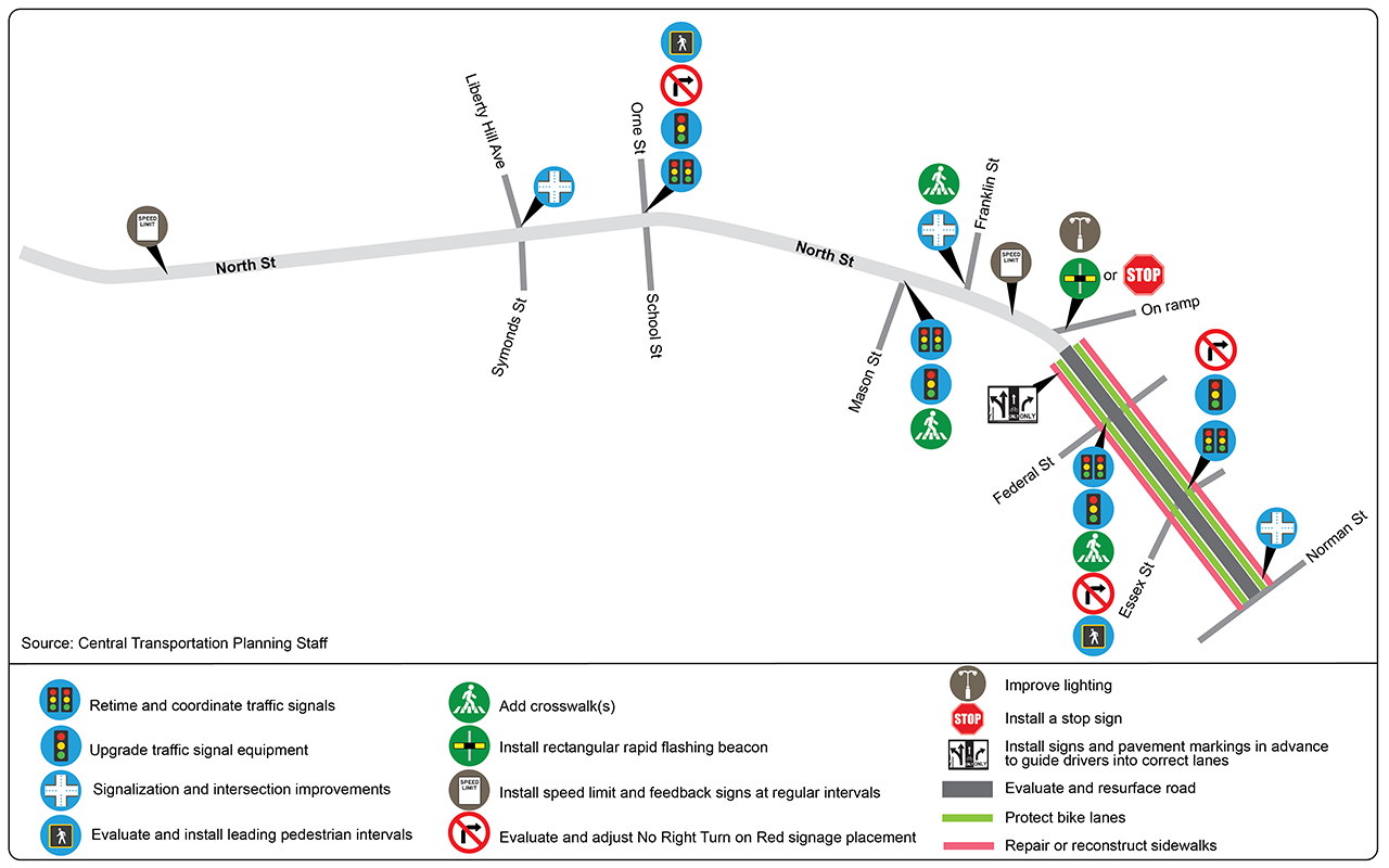
Figure 20
Potential Improvements for Norman and Washington Streets
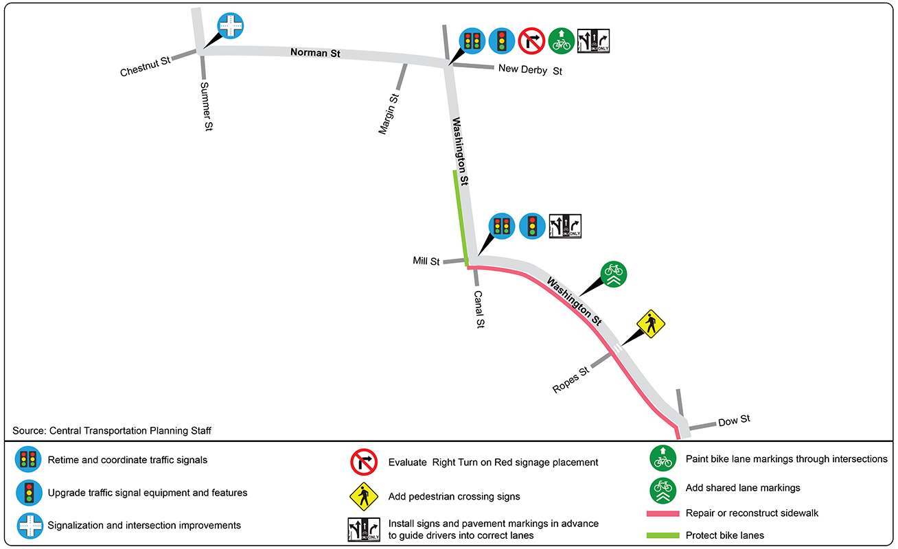
Figure 21
Potential Improvements for Lafayette Street
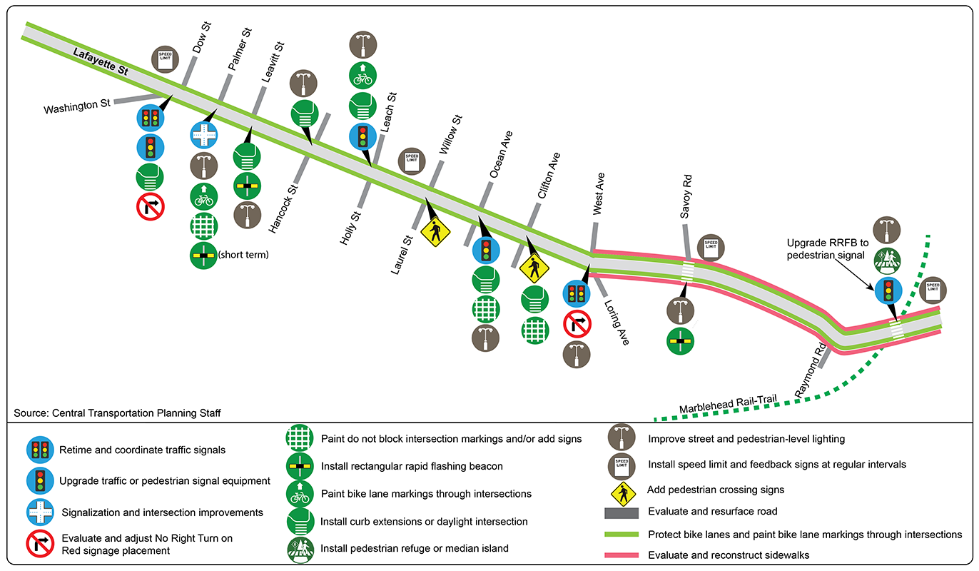
Figure 22
Safety Enhancements for Vulnerable Road Users
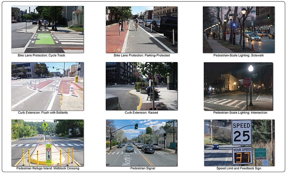
The Boston Region MPO’s transportation planning model (TDM23 2.0) was used to forecast traffic for this study to the target year of 2040. The model results projected that between 2019 and 2040 traffic volumes on Route 114 in Salem would increase by approximately 0.019 percent annually. The results also indicate that there would be minimal increases in traffic volumes in the vicinity of the study area in the future.
If the potential improvements are implemented, travel conditions in 2040, measured by total travel time, are expected to decrease by as much as 17 percent compared to 2025 levels, while delays at intersections are expected to decline by as much as 22 percent. Figures 23 and 24 show the delays and LOS projected for 2040 with the proposed improvements.
Figure 23
2040 Build: Weekday AM Peak Hour Delays and Level of Service
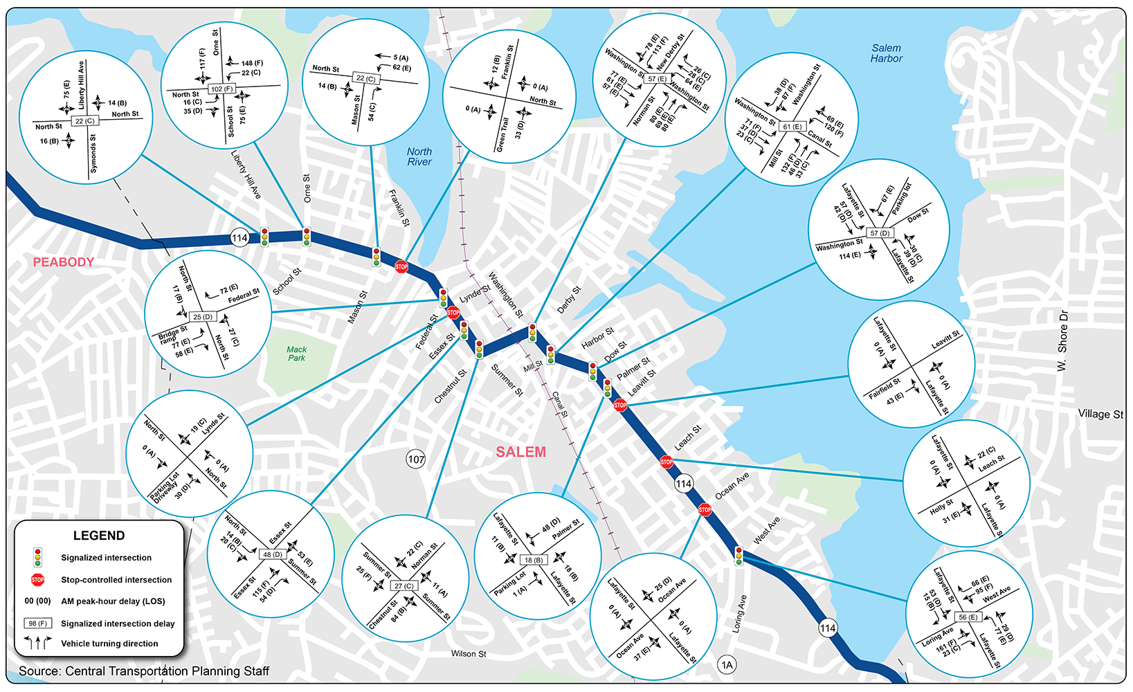
Figure 24
2040 Build: Weekday PM Peak Hour Delays and Level of Service
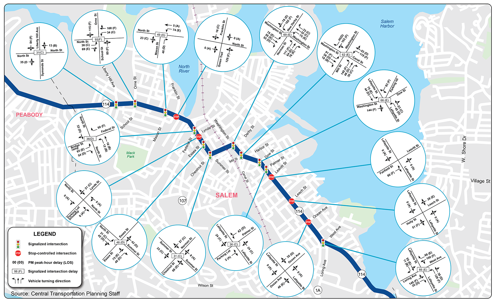
Each proposed safety improvement was selected to address specific safety deficiencies. Considering the limited funding for projects, improvements that reduce injurious and fatal crashes should be prioritized. Therefore, stakeholders must understand the extent to which a particular safety improvement, or a set of enhancements, can reduce the number of crashes. Table 7 illustrates some of the safety benefits of the proposed improvements.
Table 7
Safety Benefits of Proposed Improvements
|
Improvements |
Safety Benefit |
|---|---|
Install a rectangular rapid flashing beacon. |
Up to 47 percent reduction in pedestrian crashes |
Install a high-visibility crosswalk. |
Up to 40 percent reduction in pedestrian injuries |
Improve street lighting. |
Up to 28 percent reduction in nighttime injury crashes |
Improve intersection lighting. |
Up to 42 percent reduction in pedestrian crashes Up to 38 percent reduction in nighttime crashes |
Install advance yield or stop marking. |
Up to 25 percent reduction in pedestrian crashes |
Provide sidewalks. |
Up to 40 percent reduction in pedestrian crashes |
Implement road diets. |
Between 19 percent and 47 percent reduction in total crashes |
Install leading pedestrian intervals. |
Up to 13 percent reduction in pedestrian-vehicle crashes at intersections |
Install separated bike lanes. |
Converting traditional or flush-buffered bicycle lanes into separated bicycle lanes can reduce bicycle/vehicle crashes by up to 53 percent |
Add stop signs or stop lines. |
Up to 10 percent reduction in total crashes |
Modify clearance or change times to standards. |
Up to 50 percent reduction in red light running Up to 14 percent reduction in all crashes |
Add yellow retroreflective borders to signal heads. |
Up to 15 percent reduction in nighttime crashes |
Source: Federal Highway Administration, Crash Modification Factors Clearinghouse.
Chapter 4—Conclusion and Next Steps
Addressing deficiencies in the Route 114 corridor in Salem will involve converting the planning stage improvements into projects and identifying the necessary funding to implement them. The City of Salem is encouraged to start collaborating with MassDOT and the Boston Region MPO to initiate projects and secure funding for their design, engineering, and construction. The types of projects that can be started include the following:
There are various types of funding available through MassDOT2 and the Boston Region MPO3 for implementing projects, and Salem staff are encouraged to explore these funding options for projects on Route 114:
The improvements proposed in this report, if implemented, would significantly improve safety, mobility, and operations in the Route 114 corridor by supporting walking, biking, transit, and other transportation modes that connect Salem’s downtown, schools, residential areas, and recreational spaces. The improvements would also provide stakeholders with the opportunity to review options for addressing deficiencies in the corridor before committing funds to a roadway improvement project. The next steps are to begin project development and seek funding. The City of Salem is encouraged to start collaborating with MassDOT and the Boston Region MPO to initiate projects and secure funding for their design, engineering, and construction.
1 CUBIC Transportation Systems, 9233 Balboa Avenue, San Diego, CA 92123.
2 See MassDOT’s Grant Central website: https://madothway.my.site.com/GrantCentral/s/.
3 See the Boston Region MPO’s summary of investment programs: https://www.bostonmpo.org/data/pdf/plans/TIP/TIP-Flyer-2024-03-23.pdf.