Existing and Proposed Corridors in the Boston Region
TECHNICAL MEMORANDUM
DATE: March 19, 2026
TO: Boston Region Metropolitan Planning Organization
FROM: Shravanthi Gopalan Narayanan, MPO Staff
RE: Critical Urban Freight Corridors Update
The Massachusetts Department of Transportation (MassDOT) has requested that all metropolitan planning organizations (MPOs) in the state recommend roadways within their regions for designation as Critical Urban Freight Corridors (CUFCs) and Critical Rural Freight Corridors (CRFCs). The previous CUFC and CRFC designations were requested in 2017.
After MassDOT accepts the recommendations, the designated corridors will be incorporated into the National Highway Freight Network (NHFN). The Infrastructure Investment and Jobs Act (IIJA) requires states to include designated corridors in their State Freight Plans, and MPOs and regional planning agencies (RPAs) to collaborate in recommending corridor mileage for inclusion in the NHFN. Roadways comprising the NHFN are eligible for federal funding that specifically supports the roadway freight system.
MassDOT intends to incorporate the CUFC and CRFC designations into the 2027 Statewide Freight Plan, currently in development. To support MassDOT in this effort, MPO staff have coordinated with municipalities and the Massachusetts Port Authority (Massport) to identify new corridors and assess existing corridors for continued designation or adjustment. A Call-to-Action was issued to solicit input on potential corridors for inclusion and recommended corridors were reviewed in coordination with MassDOT. MPO staff will continue to provide coordination support to advance the finalization of updated CUFC designations in alignment with the Massachusetts Freight Plan and Federal Highway Administration (FHWA) certification requirements.
MPO staff request that the MPO board vote to release the list of roadways described in this memorandum as the recommended CUFCs for the Boston region for a 21-day public comment period. Following this public comment period, the MPO board will vote to endorse the CUFC network during the April 16, 2026, MPO meeting. Then the recommended corridors will be submitted to MassDOT for certification and then sent to FHWA for approval to be included in the National Highway Freight Network.
The National Highway Freight Network comprises the entire Interstate highway system plus additional road mileage recommended by states and MPOs, subject to approval by the FHWA. Massachusetts is permitted to designate a maximum of 150 roadway miles as part of a CUFC and 300 miles as part of a CRFC. The Boston Region MPO, which is almost entirely urban, was allocated 48.86 miles of roadway for CUFC designation. The corridors recommended in this memorandum total 48.64 miles, remaining within the allocated mileage.
MPO staff reviewed the federal guidelines and in consultation with state, local, and regional partners, identified roadways suitable for CUFC designation. This memorandum describes the CUFCs that MPO staff recommend incorporating into the NHFN. Roadways already designated for inclusion in the NHFN as part of the 2017 designation are also included as existing corridors noted in Table 1, with a few adjustments noted in Table 2.
Table 1 presents the recommended CUFCs in the Boston region including the existing corridors that will remain part of CUFC as well as the newly proposed corridors.
Table 1
Existing and Proposed Critical Urban Freight Corridors
in the Boston Region
| Corridor Status |
Municipality |
Street Name |
Start |
End |
Measured Length |
|---|---|---|---|---|---|
Existing corridor |
Foxborough |
Commercial Street |
Foxborough/Mansfield line |
Ramp- Route 140 NB to Route 95 NB (R12517) |
0.44 |
Existing corridor |
Randolph/ Canton |
Amvets Memorial Highway |
Ramp- Route 139 WB to Route 24 NB |
Interstate 93 |
3.05 |
Existing corridor |
Braintree/ Randolph |
Granite Street/Pond Street/North Street |
Teed Drive |
Interstate 93 |
3.41 |
Existing corridor |
Woburn |
Mishawum Road/Commerce Way/Atlantic Avenue/Interstate 93 Entrance Ramp |
Washington Street |
Ramp-Commerce Way to Interstate 93 NB |
1.62 |
Existing corridor |
Peabody |
Yankee Division Highway |
Ramp Route to Interstate 95 (R12716) |
Ramp Route to Interstate 95 Exit 38 (R12719) |
0.91 |
Existing corridor |
Boston |
Soldiers Field Frontage |
Western Avenue |
Cambridge Street |
0.23 |
Existing corridor |
Boston |
Curtis Street |
Route 1A |
Chelsea Street |
0.05 |
Existing corridor |
Boston |
Maffa Way |
Broadway |
Rutherford Avenue |
0.17 |
Existing corridor |
Boston |
Cambridge Street/Sullivan Square |
Ramp- Interstate 93 NB to Cambridge Street (R12155) |
Cambridge Street (merge) |
0.14 |
Existing corridor |
Boston |
Sullivan Square |
Rutherford Avenue |
West Street |
0.15 |
Existing corridor |
Boston |
South Boston Bypass Road/Haul Road (Massport) |
Interstate 93 Frontage Road |
Northern Avenue Rotary |
2.00 |
Existing corridor |
Boston |
Pumphouse Road |
Summer Street |
Haul Road |
0.06 |
Existing corridor |
Boston |
Summer Street |
Thomas J. Butler Freight Corridor |
Pumphouse Road |
0.38 |
Existing corridor |
Boston |
Cypher Street |
South Boston Bypass Road |
D Street |
0.25 |
Existing corridor |
Boston |
E Street |
Fargo Street |
New Cypher Street |
0.39 |
Existing corridor |
Boston |
Fargo Street |
E Street |
Summer Street |
0.11 |
Proposed corridor |
Boston |
Summer Street |
Pumphouse Road |
D Street |
0.12 |
Proposed corridor |
Boston |
D Street |
Congress Street |
Summer Street |
0.15 |
Proposed corridor |
Boston |
Congress Street |
Ramps |
D Street |
0.20 |
Proposed corridor |
Boston |
Northern Avenue Rotary/Fid Kennedy |
Haul Road |
Tide Street |
0.37 |
Proposed corridor |
Boston |
New Cypher Street |
D Street |
E Street |
0.11 |
Existing corridor |
Everett |
Ramp- Route 99 (Sweetser Cir) to Route 16 EB |
2nd Street |
Revere Beach Parkway |
0.33 |
Existing corridor |
Everett |
2nd Street |
Spruce Street |
Revere Beach Parkway |
0.87 |
Existing corridor |
Everett/ Boston |
Broadway/Alford Street/Sullivan Square Tunnel/New Rutherford Avenue |
Norwood Street/Chelsea Street (N1299 NB/N2286 NB in Everett) |
Ramp – Route 99 (Sweetser Circle) to Route 16 EB |
2.57 |
Proposed corridor |
Everett |
Robin Street |
Dexter Street |
Beacham Street |
0.33 |
Proposed corridor |
Everett |
Commercial Street |
Behen Street |
Mystic River |
0.27 |
Proposed corridor |
Everett/ Boston |
Broadway/Alford Street/Sullivan Square Tunnel/New Rutherford Avenue |
Ramp – Route 99 (Sweetser Circle) to Route 16 EB |
Chelsea Street (N449 NB) in Charlestown (Boston) |
0.40 |
Existing corridor |
Chelsea/ Boston |
Martin A. Coughlin Road/East Boston Haul Road/Chelsea Street |
Frankfort Street |
Eastern Avenue/Central Avenue/Marginal Street |
0.74 |
Existing corridor |
Chelsea |
Spruce Street |
2nd Street |
Williams Street |
0.11 |
Existing corridor |
Chelsea/ Everett |
Beacham Street/Williams Street/Marginal Street/Eastern Avenue |
Broadway/Route 99 |
Crescent Avenue |
3.19 |
Existing corridor |
Cambridge |
Western Avenue |
Soldiers Field Frontage Road |
Massachusetts Avenue |
0.74 |
Existing corridor |
Cambridge |
River Street |
Soldiers Field Frontage Road |
Massachusetts Avenue |
0.78 |
Existing corridor |
Cambridge |
Massachusetts Avenue/Pleasant Street |
Western Avenue |
Sidney Street Exit |
0.50 |
Existing corridor |
Cambridge |
Main Street/Sidney Street Exit |
Massachusetts Avenue |
Galileo Way |
0.52 |
Existing corridor |
Cambridge |
Galileo Way/Binney Street |
Main Street |
Edwin H. Land Boulevard |
0.85 |
Existing corridor |
Cambridge |
Edwin H. Land Boulevard/Charlestown Avenue/Gilmore Bridge/Austin Street |
Binney Street |
Rutherford Avenue/New Rutherford Avenue |
0.82 |
Proposed corridor |
Malden |
Commercial Street |
Pleasant Street |
Medford border |
0.87 |
Proposed corridor |
Malden |
Highland Avenue |
Pleasant Street |
Medford border |
0.80 |
Proposed corridor |
Malden |
Broadway |
Eastern Avenue (MA-60) |
Leonardo Avenue |
1.18 |
Proposed corridor |
Malden/ Revere |
Pleasant Street/Center Street/Eastern Avenue/Lynn Street/Beach Street/Squire Road/American Legion Highway |
West Street |
Bell Circle Rotary |
5.44 |
Proposed corridor |
Malden/ Revere |
Frank P. Bennett Highway/Cutler Highway/US Route 1 |
Ramp Route to Route 16 (R21006) |
Ramp - Route 1 NB to Salem Street (R21011) |
2.34 |
Proposed corridor |
Revere |
Lee Burbank Highway/Veterans of Foreign Wars Parkway/North Shore Road/Route 1A |
Tomasello Way |
Oak Island Street |
2.62 |
Proposed corridor |
North Reading |
Park Street |
Concord Street |
Main Street (Route 28) |
0.51 |
Proposed corridor |
North Reading |
Lowell Road |
Salem Street |
Main Street (Route 28) |
1.10 |
Proposed corridor |
North Reading |
Main Street |
Park Street |
Lowell Road |
0.94 |
Proposed corridor |
Medway |
Milford Street/Main Street |
Clark Street |
Holliston Street |
3.57 |
Proposed corridor |
Littleton |
King Street/Ayer Road |
Ramp – Route 2A to Route 495SB (R13131) |
Spectacle Pond Road |
1.97 |
Total Mileage |
48.64 |
||||
EB = eastbound. NB = northbound. SB = southbound. WB = westbound.
Boston Region MPO staff, in coordination with municipal and regional partners, reviewed the existing corridors to assess whether adjustments were required to better reflect current freight activity in the region. Table 2 summarizes the proposed adjustments identified to the existing CUFC network, with the supporting reasons for the adjustments.
Table 2
Adjustments to the Existing Critical Urban Freight Corridors
in the Boston Region
Corridor Status |
Municipality |
Street Name |
Start |
End |
Measured Length |
Reason |
Proposed for removal |
Boston |
D Street |
Cypher Street |
W 1st Street |
-0.06 |
Removed due to New Cypher Street construction |
Proposed for removal |
Boston |
W 1st Street |
E Street |
D Street |
-0.10 |
Removed due to New Cypher Street construction |
Proposed for removal |
Boston |
E Street |
New Cypher Street |
W 1st Street |
-0.06 |
Removed due to New Cypher Street construction |
Proposed for removal |
Boston |
Summer Street |
East First Street |
Thomas J. Butler Freight Corridor |
-0.2 |
This segment of Summer Street may no longer be necessary as part of the freight route due to Thomas J. Butler corridor connectivity. |
Adjustment |
Avon |
Amvets Memorial Highway |
Randolph/ Avon town line |
Interstate 93 |
-4.06 |
The Randolph segment of the Amvets Memorial Highway is included in this update as an existing corridor. The Avon segment from the last update is removed as Avon is within the Old Colony MPO area. |
Total adjustments |
-4.48 |
|
||||
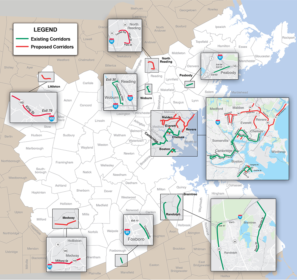
Figure 1 illustrates the existing and proposed CUFCs in the Boston region, providing regional context for the CUFC network. This figure is followed by a series of figures that highlight the existing and proposed corridor segments and their significance.
Figure 1
Existing and Proposed Corridors in the Boston Region
The following maps in Figures 2 through 10 illustrate the existing and proposed CUFCs. These figures provide additional context regarding the significance of selected corridors within the regional freight network. In the maps, green indicates previously designated CUFCs, while red represents proposed corridors included in this update.
Figure 2
Existing and Proposed Corridors in Malden, Everett, Chelsea, and Revere
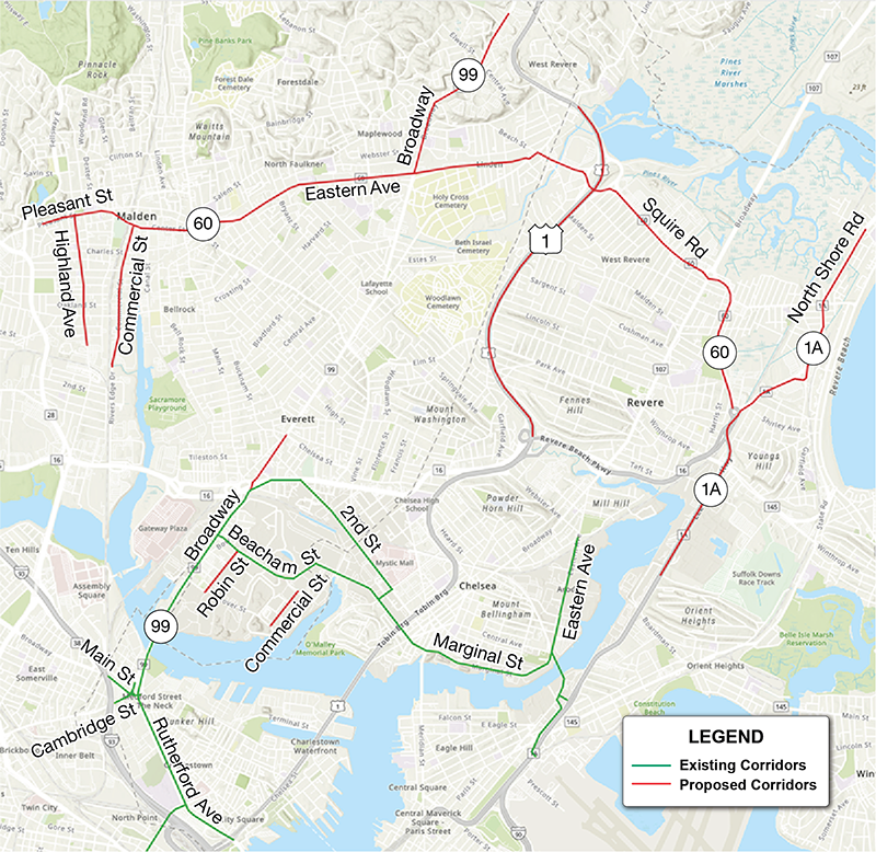
Source: Boston Region MPO Staff.
Figure 2 highlights the proposed corridors from Malden, Everett, Chelsea, and Revere. In Malden, Highland Avenue, Commercial Street, Route 60 (Pleasant Street, Center Street, Eastern Avenue, Lynn Street, and Beach Street), and Broadway (north of Route 60) are proposed for inclusion.
As a continuation of proposed corridors along Route 60 in Malden, Squire Road and American Legion Highway in Revere are also proposed for inclusion. In addition, Route 1A (Lee Burbank Highway, Veterans of Foreign Wars Parkway, North Shore Road, and Route 1A) and US Route 1 (Frank P. Bennett Highway, Cutler Highway, and US Route 1) are proposed for inclusion.
Figure 2 also highlights the previously designated CUFCs in the area, which includes Spruce Street, Beacham Street, Williams Street, Marginal Street, and Eastern Avenue.
Figure 3
Existing and Proposed Corridors in Cambridge
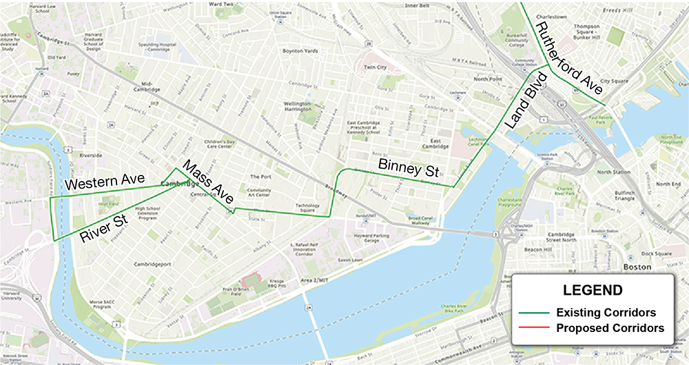
Source: Boston Region MPO Staff.
Figure 3 highlights the existing designated truck routes in Cambridge upon which the transportation of hazardous cargoes is allowed. Hazardous cargoes are prohibited in the tunnels in Boston. This figure also highlights the Route 99 corridor, shown in Figure 2, extending along Broadway, Alford Street, Sullivan Square Tunnel, and New Rutherford Avenue, which serves as the only harbor crossing available for hazardous cargo.
Figure 4
Existing and Proposed Corridors in South Boston
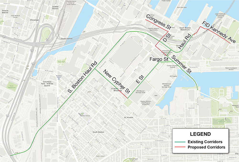
Source: Boston Region MPO Staff.
Figure 4 shows the existing CUFCs in the City of Boston: the South Boston Bypass Road, Haul Road, and Massport Haul Road. The proposed CUFCs extend into Harbor Street and Fid Kennedy Avenue on the other side of the roundabout on Northern Avenue.
Congress Street, D Street, and Summer Street (the segment between Pumphouse and D Street) are proposed for inclusion, as these are preferred truck routes serving the industrial area in South Boston. While an existing corridor, the Summer Street segment between Thomas J. Butler Corridor and East First Street is proposed for exclusion (refer to Table 2).
Massport recently completed construction of New Cypher Street, which extends Cypher Street to E Street in South Boston to create a more streamlined route for freight and truck access. (See Figure 5.) This results in the removal of D Street, W 1st Street, and E Street from the CUFC designation and adds New Cypher Street instead.
Figure 5
Newly Constructed Corridor in South Boston
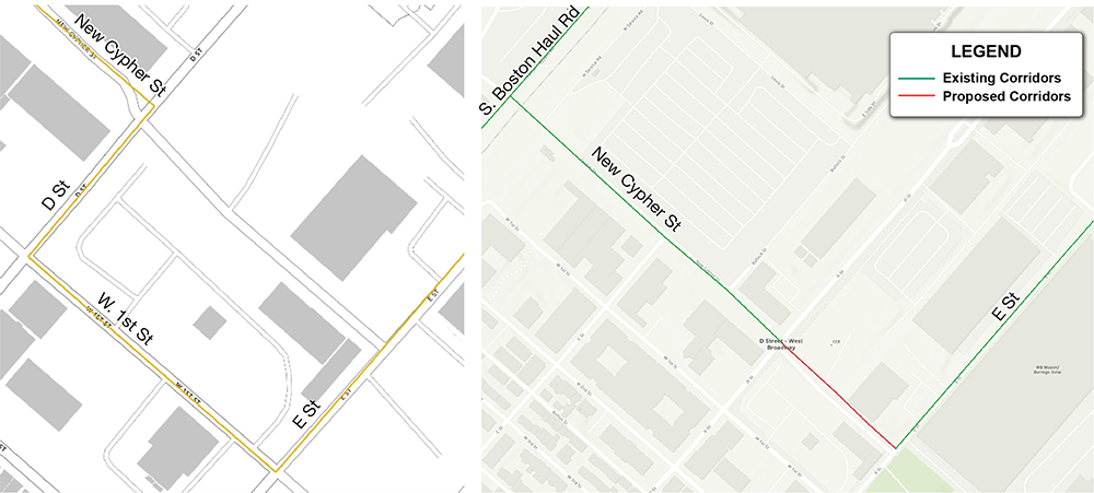
Source: Figure 5a (left): National Highway Freight Network Visualization Tool; Figure 5b (right) MPO staff.
Figure 5a (left) shows the former CUFC: D Street, W 1st Street, and E Street. Figure 5b (right) shows the proposed inclusion of New Cypher Street to the CUFC and the removal of D Street, W 1st Street, and E Street.
Figure 6
Newly Proposed Corridors in Littleton
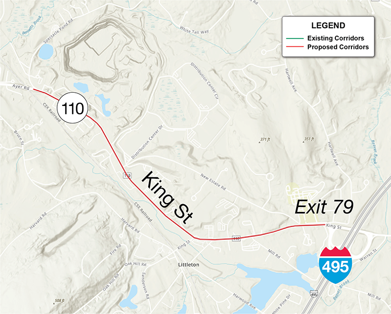
Source: Boston Region MPO Staff.
Figure 6 highlights a segment of King Street and Ayer Road (Route 2A/110) in the Town of Littleton. The section between Interstate 495 and Spectacle Pond Road is proposed for CUFC designation. This corridor provides access to a gravel quarry, distribution and warehouse complex, manufacturing facilities, and a bottling plant, and it provides access for through-traffic to the Town of Ayer's economic hubs off of Willow Road, Littleton Road, and Sandy Pond Road.
Figure 7
Newly Proposed Corridors in North Reading
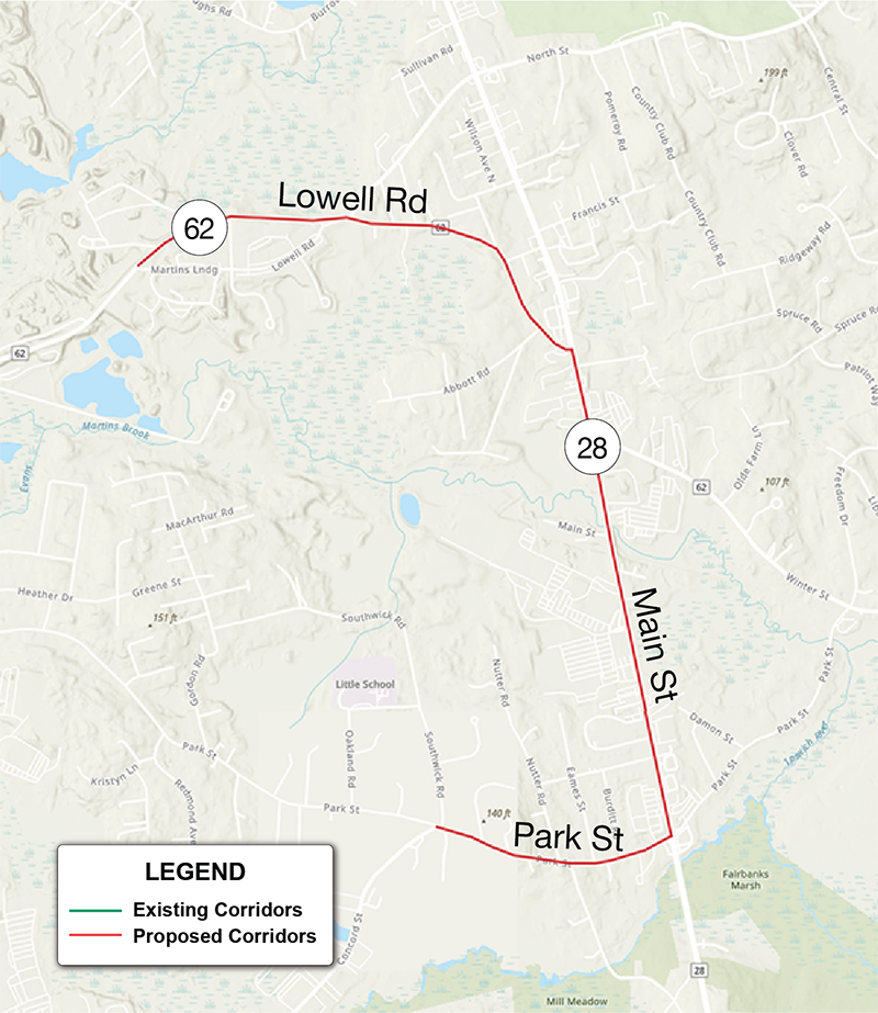
Source: Boston Region MPO Staff.
Figure 7 highlights a set of proposed CUFC corridors in North Reading that serve as key connecting segments to Route 125 and Interstate 93 and provide access to industrial areas along the corridor.
Figure 8
Existing Corridors in Woburn (8a) and Peabody (8b)
Source: Boston Region MPO Staff.
Figure 8a highlights Mishawum Road, Commerce Way, and Atlantic Avenue in Woburn between the Interstate 93 entrance ramp and Washington Street. This corridor serves an extensive industrial area and is a critical connection to Interstate 93 in Woburn.
Figure 8b highlights an existing corridor in the Yankee Division Highway between Ramp Route to Interstate 95 (R12716) and Ramp Route to Interstate 95 Exit 38 (R12719), which is a key connecting segment between a Non-Primary Highway Freight System (Non-PHFS) and Primary Highway Freight System (PHFS) on Interstate 95.
Figure 9
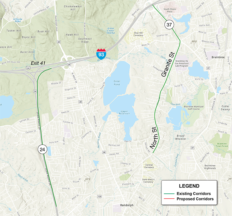
Existing Corridors in Foxborough (9a), Braintree and Randolph (9b)
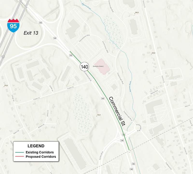
Source: Boston Region MPO Staff.
Figure 9a highlights Commercial Street along the Foxborough/Mansfield town line, which serves an extensive industrial area.
Figure 9b highlights Amvets Memorial Highway (State Route 24) between Ramp Route 139 westbound to Route 24 northbound and Interstate 93, which serves extensive industrial areas, connects to the PHFS to the north, and continues as a CUFC in the neighboring RPA in the south.
This figure also highlights Granite Street, Pond Street, and North Street in the City of Braintree and Town of Randolph, which serves as a key connecting segment to the nearby Interstate 93.
Figure 10
Newly Proposed Corridors in Medway
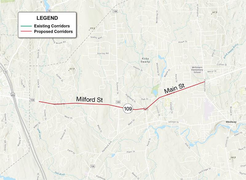
Source: Boston Region MPO Staff.
Figure 10 highlights Milford Street and Main Street (Route 109) in the Town of Medway, which serves as a critical continuation of Route 109 providing access to Interstate 495.
As noted previously, the Boston Region Metropolitan Planning Organization is recommending the corridors listed in Table 1 for designation as Critical Urban Freight Corridors for inclusion in the National Highway Freight Network.
Following the public comment period and the MPO board’s endorsement of the CUFC network, the recommended corridors will be submitted to MassDOT for certification, after which MassDOT will submit them to FHWA for approval. Once approved by FHWA, the corridors will be incorporated into the next Massachusetts Freight Plan, and projects located on these designated corridors will become eligible for the National Highway Freight Program funding.
CIVIL RIGHTS NOTICE TO THE PUBLIC Welcome. Bem Vinda. Bienvenido. Akeyi. 欢迎. 歡迎
You are invited to participate in our transportation planning process, free from discrimination. The Boston Region Metropolitan Planning Organization (MPO) is committed to nondiscrimination in all activities and complies with Title VI of the Civil Rights Act of 1964, which prohibits discrimination on the basis of race, color, or national origin (including limited English proficiency). Related federal and state nondiscrimination laws prohibit discrimination on the basis of age, sex, disability, and additional protected characteristics.
For additional information or to file a civil rights complaint, visit www.bostonmpo.org/mpo_non_discrimination.
To request this information in a different language or format, please contact:
Boston Region MPO Title VI Specialist 10 Park Plaza, Suite 2150 Boston, MA 02116 Phone: 857.702.3700 Email: civilrights@ctps.org
For people with hearing or speaking difficulties, connect through the state MassRelay service, www.mass.gov/massrelay. Please allow at least five business days for your request to be fulfilled.
|