Date: October 1, 2026
To: Patrick Deschenes, Town of Walpole
From: Shravanthi Gopalan Narayanan, Boston Region MPO Staff
Re: Intersection Study: US Route 1 and High Plain Street, Walpole
This memorandum summarizes the analyses and improvement strategies for the intersection of US Route 1 (Boston–Providence Highway) at Route 27 (High Plain Street) in the Town of Walpole.
This memorandum contains the following sections:
This memorandum also includes technical appendices that contain data and methods applied in the study.
The Boston Region Metropolitan Planning Organization (MPO) conducts studies of intersections with safety and mobility concerns as part of the Multimodal Mobility Infrastructure Program (MMIP). The outcomes of these studies are recommended improvements that focus on all roadway users within a Complete Streets framework, including people walking, biking, driving, using assistive mobility devices, and taking transit. Municipalities in the region and the Massachusetts Department of Transportation (MassDOT) have been receptive to these studies, which provide the opportunity to review conceptual options to improve a specific intersection before committing design and engineering funds to a project. If a proponent initiates a project that qualifies for state and federal funds, the study’s documentation may be useful to both MassDOT and the project proponent for completing MassDOT Highway Division’s project initiation forms, identifying problems at the intersection, justifying the need for improvements, and providing improvement concepts to advance into the preliminary design and engineering stages.
Each year, the MPO identifies intersections that should be prioritized for improvements based on the following selection criteria: safety, multimodal significance, regional significance, and equity. When selecting intersections to study, the MPO also considers geographical distribution (to ensure that studies are provided across the Boston region) and the potential for study recommendations to be implemented.
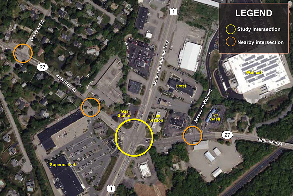
The intersection of Route 1 at High Plain Street in the Town of Walpole was one of the intersections selected for study in Federal Fiscal Year (FFY) 2025. Due to the proximity of three nearby signalized intersections, these intersections were added to the study as secondary intersections: High Plain Street at the Big Y driveway, High Plain Street at Old Post Road, and High Plain Street at the Walmart driveway.
Walpole is in Norfolk County approximately 18 miles from Boston with a population of about 27,000. Route 1 serves as a major commercial corridor, providing access to Walpole’s large businesses and its intersection with High Plain Street is identified as a location with a key safety concern. The intersection is among the Top 200 Crash Clusters of 2019–21 and an eligible Highway Safety Improvement Program (HSIP) intersection crash cluster in Massachusetts.
The crash rate at each intersection in the study area is significantly higher than the MassDOT District 5 average. Based on the Boston Region MPO’s Vision Zero crash analysis, the intersection is identified as part of both the municipal and regional High-Injury Networks (HIN), indicating that it is among the highest-priority locations for safety improvements. Within Walpole, the corridor is among the Town’s top 5 percent of high-crash corridors. Regionally, the intersection is also identified within the top 5 percent of high-crash intersections in the Boston Region MPO area.
The Vision Zero safety analysis further identifies this location as a primary risk site for intersection and vulnerable road user crashes and a secondary risk site for lane departure crashes. The intersection is very busy as it provides access to Walmart Supercenter, Big Y supermarket, and several retail stores. This intersection could be improved to better accommodate people accessing nearby businesses.
Figure 1
Study Area
Source: Boston Region MPO staff.
Figure 1 shows the intersections studied, which includes the primary (study intersection) and secondary (nearby) intersections within the study area. The study intersection is the intersection of Route 1 and High Plain Street.
Secondary intersections in the study area are
Route 1 is an important state highway, running north-south through Walpole. It is classified as an urban principal arterial and is part of the National Highway System (NHS). This section of highway is a four-lane, two-way, divided roadway that widens at the signalized intersections to accommodate a right-turn lane and a left-turn lane on each approach. This roadway serves regional and local traffic, carrying between 40,000 and 50,000 vehicles per day. The posted speed limit is 45 miles per hour (mph) in both directions near the intersection and 55 mph farther away from the intersection in both directions. There are no sidewalks or bike lanes along Route 1 in the study area. Route 1 connects to Interstate 95 south of the study area. There are many businesses and retail stores along US Route 1.
High Plain Street is a town-owned arterial in Walpole. It is classified as an urban principal arterial and is part of the NHS. High Plain Street connects to Old Post Road, Washington Street, and East Street to the west, providing access to Walpole Town Center. To the east, it continues as Edge Hill Road into the Town of Sharon. The section within the study area is a two-lane, two-way, undivided street that widens at the signalized intersections to accommodate a left-turn lane on each approach. It serves regional and local traffic carrying between 15,000 and 20,000 vehicles per day. The posted speed limit is 25 mph in both directions near the intersection and 30-35 mph away from the intersection in both directions. Sidewalks are present on both sides west of the intersection and on one side east of the intersection. There are no bike lanes within the study area. The surrounding land use is a mix of commercial and residential uses.
Old Post Road is a town-owned major collector in Walpole. It is a two-lane, two-way, undivided street that serves primarily local traffic carrying fewer than 10,000 vehicles per day. The posted speed limit is 25 mph in both directions near the intersection and 30 mph away from the intersection in both directions.
MPO staff conducted a kick-off meeting with the Town of Walpole staff on September 24, 2024, to provide an overview of the study process and discuss their expectations. Following the kick-off meeting, a study site visit was scheduled for November 6, 2024.
Key observations from the site visit were as follows:
Additional observations are discussed in Section 3.
In coordination with the Town of Walpole, MPO staff developed a list of Advisory Task Force members for the study, which consisted of representatives from the town, MassDOT District 5, the Town of Sharon, businesses and consultants.
MPO staff coordinated with members of the Advisory Task Force to inform them about the study kick-off meeting, which was held on February 6, 2025.
MPO staff also met with the Advisory Task Force on March 3, 2026, to present findings from the existing conditions assessment, survey results, data analysis, and preliminary recommendations, and to solicit their feedback to inform the study recommendations.
MPO staff collaborated with the MPO’s Communications and Engagement team and the Town of Walpole staff to develop an engagement plan for the study. As part of this effort, MPO staff developed a brief survey that was distributed and promoted through various Town communication channels. Businesses represented on the Advisory Task Force were also encouraged to share the survey with their networks to expand outreach efforts.
To gather input from residents living near the intersection, MPO staff created a mailer that included a study overview and a QR code linking directly to the survey. The Town staff distributed the mailer to the neighborhood near the intersection, located within 600 feet of the primary study intersection.
The survey included approximately eight questions, along with a few additional skip logic/conditional questions based on respondents’ answers. The survey covered topics such as travel mode, safety concerns, transportation-related challenges, travel patterns, popular destinations, desired improvements, and opportunities for any additional comments. The goal of the survey was to gather input from residents and intersection users on existing challenges, identify community concerns and priorities, and inform the analysis and development of study recommendations.
The survey was launched during the Advisory Task Force kick-off meeting on February 6, 2025, and remained open for approximately a month, closing on March 6, 2025. A total of 365 responses were received. The survey questionnaire and responses are included in Appendix A and Appendix B.
A majority of the respondents (69 percent) identified as residents of the town, and 25 percent indicated that they live in close proximity to the intersection. The responses revealed the following:
Among survey respondents who walk, bike, or use an assistive mobility device at the intersection, the most concern was about the high volume of traffic and vehicle speeds at the intersection, inattentive or aggressive drivers, and poorly maintained infrastructure. Additional concerns included broken walk signals and buttons, long wait times for pedestrian signals, poor lighting at night, absence of bike lanes, and insufficient pedestrian signal timing to cross Route 1.
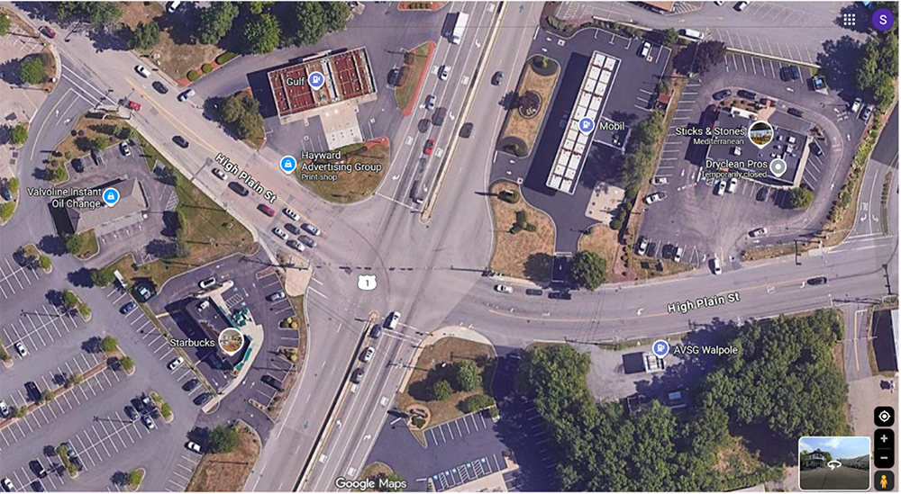
Respondents who drive through the intersection raised a range of operational and safety concerns. Those related to turning movements and lane markings are as follows (Figure 2):
Figure 2
Existing Pavement Markings
Source: Google Maps.
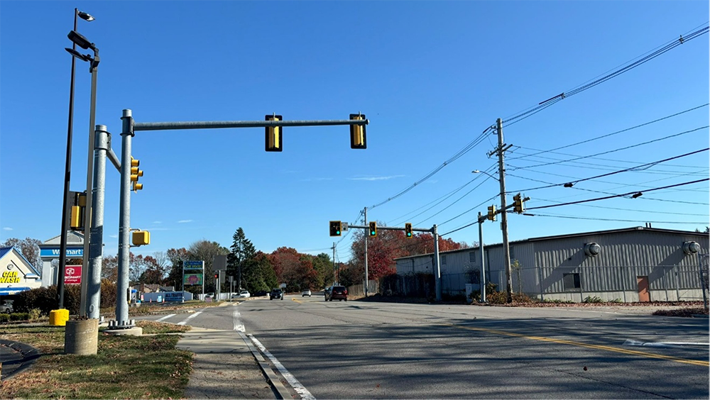
Concerns related to signals, signal timing, and vehicle queuing are as follows (Figure 3):
Figure 3
Signal at Walmart Entrance and High Plain Street Intersection
Source: Boston Region MPO staff.
Based on field observations, discussions with Town officials, public engagement findings, and analyses of crash data and existing conditions, several key issues were identified within the study area. The primary intersection ranks 122nd in the Massachusetts Top 200 Crash Clusters for 2019–21 and is also categorized within the top 5 percent of crash clusters statewide for the same period. The Equivalent Property Damage Only (EPDO) score at this intersection is 263 (for 2019–21), indicating a high level of crash severity. Additionally, the average crash rate at this signalized intersection exceeds the MassDOT district average, further underscoring significant safety concerns.
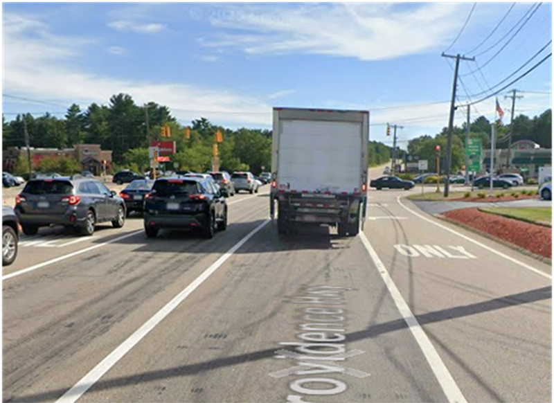
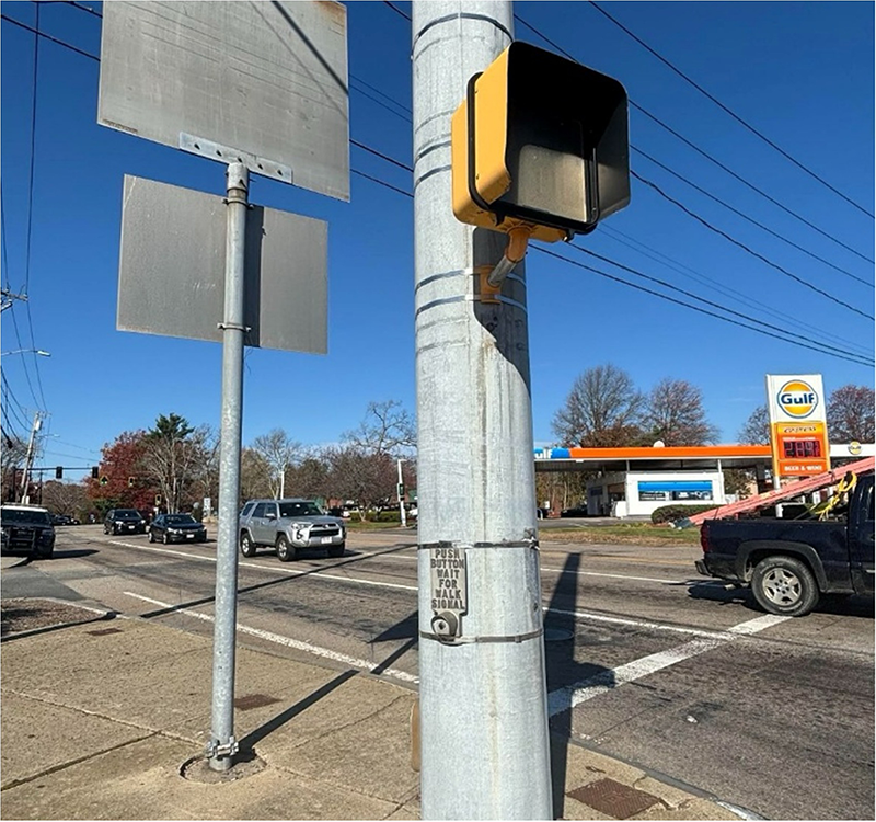
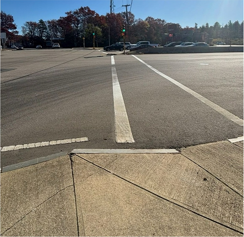
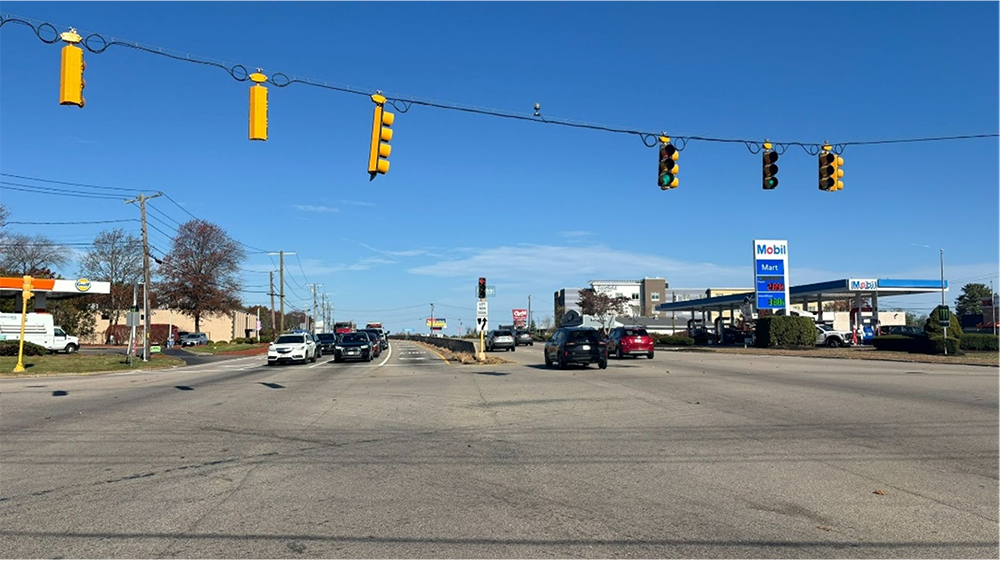
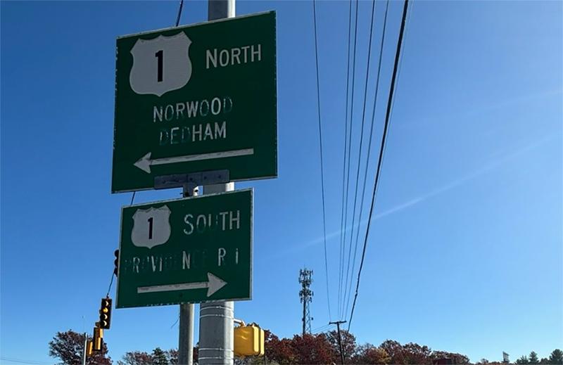
Field observations relating to traffic signals and operations, pedestrian access, pavement markings, and signage are described below.
Figure 4
Signal Visibility behind Large Vehicles at US Route 1 Intersection
Source: Google Maps.
Figure 5
Push Button at US Route 1 and High Plain Street Intersection
Source: Boston Region MPO staff.
Figure 6
Crosswalk and Curb Ramp at the US Route 1 Intersection
Source: Boston Region MPO staff.
Figure 7
Lack of Turn Markings at the US Route 1 Intersection
Source: Boston Region MPO staff.
Figure 8
Condition of Signage in the Study Area
Source: Boston Region MPO staff.
Crash data analysis is essential to identify safety and operational problems at an intersection. Crash data has information on crash patterns, types of crashes, frequency of crashes, and the circumstances under which crashes occur, such as the time of day and roadway surface conditions. This information helps identify the problem areas and helps in making data-driven decisions to prioritize safety improvements at an intersection.
MPO staff used the most recent six-year crash reports (January 2019–December 2024) for this study. Data were obtained using MassDOT’s IMPACT Crash Portal. Typically, five years of crash data is used, but for this study an additional year of crash data was collected to account for the COVID-19 pandemic effects on vehicular travel in 2020. It should be noted that these are just reported crashes.
Table 1 summarizes the crashes in terms of severity, collision type, pedestrian or bicycle involvement, time of the day, weather, and roadway conditions. There were a total of 153 crashes near the intersection.
Table 1
Crash Summary for the Intersection of US Route 1 at High Plain Street
| Statistics Period |
2019 |
2020 |
2021 |
2022 |
2023 |
2024 |
6-Year Total |
Annual Average |
|---|---|---|---|---|---|---|---|---|
Total number of crashes |
29 |
26 |
24 |
23 |
23 |
28 |
153 |
25.5 |
Severity |
|
|
|
|
|
|
|
|
Property damage only |
24 |
22 |
20 |
18 |
21 |
27 |
132 |
22 |
Non-fatal injury |
5 |
4 |
4 |
5 |
2 |
1 |
21 |
3.5 |
Fatality |
0 |
0 |
0 |
0 |
0 |
0 |
0 |
0.0 |
Not reported/unknown |
0 |
0 |
0 |
0 |
0 |
0 |
0 |
0.0 |
Collision type |
|
|
|
|
|
|
|
|
Single vehicle |
1 |
1 |
2 |
0 |
0 |
1 |
5 |
0.8 |
Rear-end (or) Front to rear |
12 |
10 |
8 |
11 |
9 |
12 |
62 |
10.3 |
Angle |
12 |
10 |
9 |
6 |
7 |
8 |
52 |
8.7 |
Sideswipe, same direction |
3 |
5 |
3 |
5 |
5 |
5 |
26 |
4.3 |
Sideswipe, opposite direction |
0 |
0 |
1 |
0 |
1 |
1 |
3 |
0.5 |
Head-on (or) Front to Front |
0 |
0 |
0 |
1 |
1 |
1 |
3 |
0.5 |
Rear-to-rear |
0 |
0 |
0 |
0 |
0 |
0 |
0 |
0.0 |
Rear-to-side |
1 |
0 |
1 |
0 |
0 |
0 |
2 |
0.3 |
Not reported/unknown |
0 |
0 |
0 |
0 |
0 |
0 |
0 |
0.0 |
Involved pedestrian(s) |
1 |
0 |
0 |
1 |
1 |
0 |
3 |
0.5 |
Involved cyclist(s) |
0 |
0 |
0 |
0 |
0 |
0 |
0 |
0.0 |
Occurred during weekday peak periods* |
16 |
9 |
7 |
8 |
9 |
12 |
61 |
10.2 |
Wet, icy, or snowy pavement conditions |
4 |
5 |
5 |
3 |
2 |
5 |
24 |
4.0 |
Dark conditions (lit or unlit) |
4 |
7 |
7 |
5 |
5 |
5 |
33 |
5.5 |
Notes:
Peak periods are defined as 6:00 AM–9:00 AM and 3:00 PM–6:00 PM.
The 2024 crash data analyzed were not closed at the time of analysis.
Source: Boston Region MPO staff.
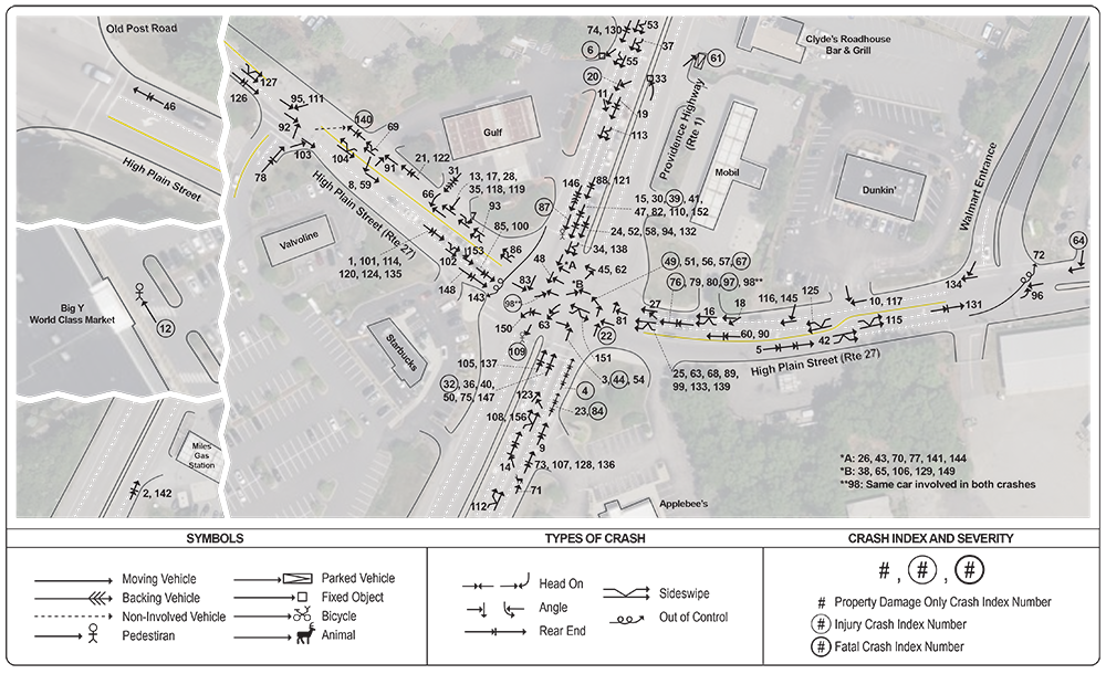
Based on police and incident reports, staff constructed a collision diagram that shows the locations and patterns of all the crashes in the study area (Figure 9). Rear-end crashes are the most common type of crash at the intersection, followed by angle and same-direction sideswipe crashes. The information about each crash, including date, time, severity, manner of collision, first harmful event, and road and light conditions are summarized in Appendix C.
Figure 9
Collision Diagram
Source: Boston Region MPO staff.
MPO staff coordinated with MassDOT to obtain Automatic Traffic Recorder (ATR) counts and intersection turning movement counts (TMCs) for this study. The ATR counts were performed during the week of December 9-13, 2024. Additional details on the ATR counts are provided in Appendices D through H.
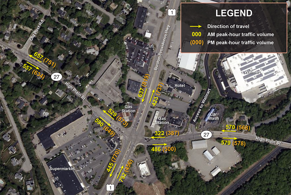
Based on the data, staff estimated the average weekday traffic volumes in roadway sections near the intersection as follows and as shown in Figure 10:
Figure 10
Weekday Peak-Hour Average Traffic Volume
Source: Boston Region MPO staff.
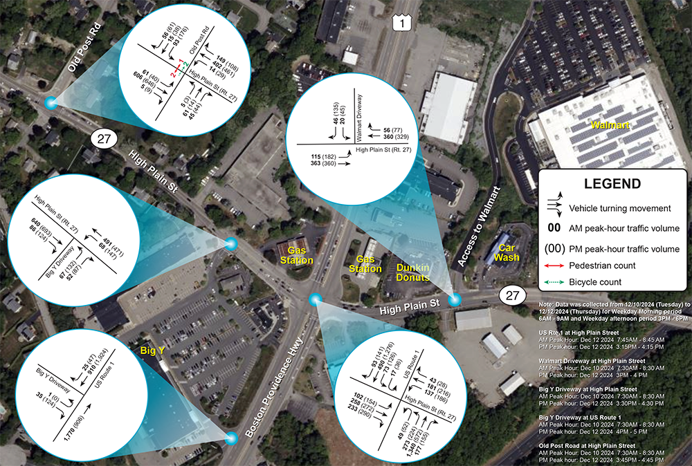
MassDOT collected turning movement counts at the study intersection on Tuesday, December 10, 2024, and Thursday, December 12, 2024, during the weekday morning peak period (6:00 AM–9:00 AM) and the weekday evening peak period (3:00 PM–6:00 PM). Figure 11 summarizes the 2024 AM and PM peak-hour traffic turning volumes by approach at intersections. A detailed weekly volume summary from the data collection is included in Appendix I.
Figure 11
Turning Movement Counts
Source: Boston Region MPO staff.
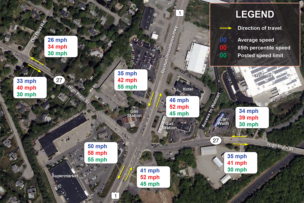
Speeding was mentioned as a concern in the study area. As mentioned above, the speed limit along Route 1 changes from 55 mph to 45 mph closer to the intersection, while the speed limit along High Plain Street is 30 mph. Speed data were also collected between Tuesday, December 10, 2024, and Thursday, December 12, 2024. Figure 12 below shows the average speed and 85th percentile speed along High Plain Street and Route 1. The Route 1 speed data were collected within the 45 mph posted speed limit. Overall, data indicate that vehicles are speeding along High Plain Street and traveling at speeds slightly above the posted speed limit along Route 1. A detailed speed summary from the data collection is included in Appendix J. Also, a detailed vehicle classification summary is available in Appendix K.
Figure 12
Speed Data
Source: Boston Region MPO staff.
MPO staff conducted an intersection capacity analysis for the intersection of Route 1 at High Plain Street and nearby intersections using the Synchro traffic analysis and simulation program. The analysis was based on the 2024 weekday AM and PM peak-hour turning movement counts.
The analysis was performed in accordance with Highway Capacity Manual (HCM) methodologies to evaluate the level of service (LOS) and delays at intersections within the study area. HCM methodology evaluates operating conditions at signalized and unsignalized intersections, assigning ratings from A to F. LOS A represents the best operating conditions with little to no delay, LOS E indicates operations at capacity, and LOS F represents the worst operating conditions with very long delays. An intersection LOS criteria table from the HCM methodology can be found in Appendix L. Detailed Synchro capacity analysis outputs are included in Appendices M through R.
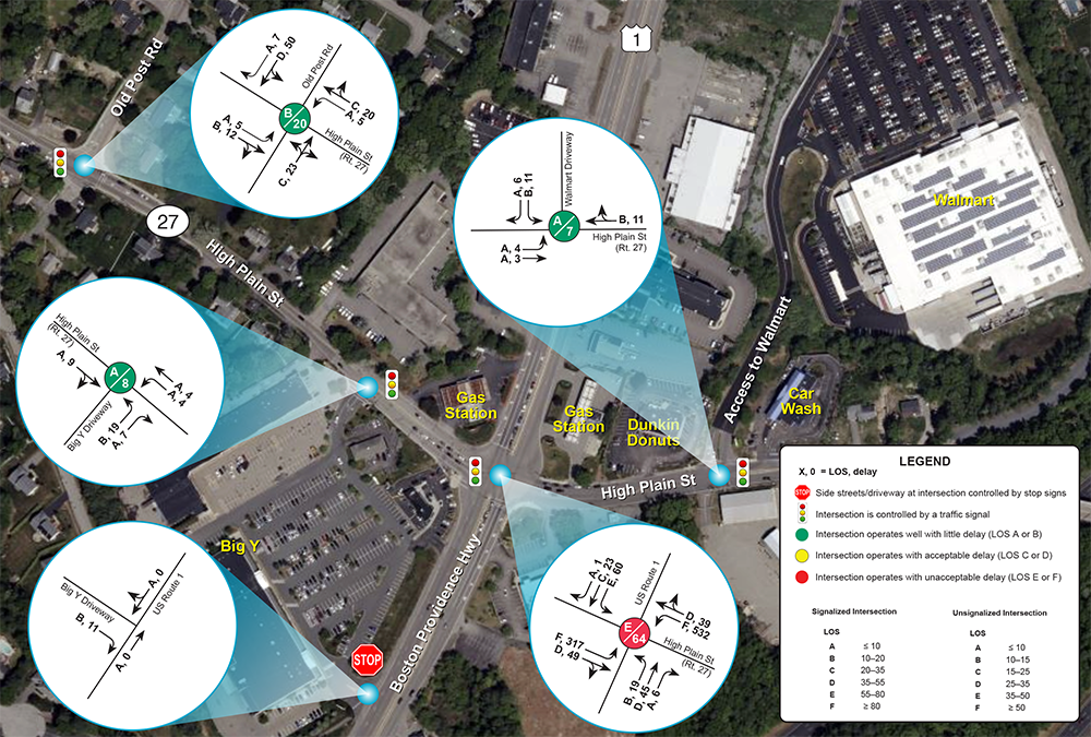
Figure 13
Weekday AM Peak-Hour LOS and Delays
LOS = Level of Service.
Source: Boston Region MPO staff.
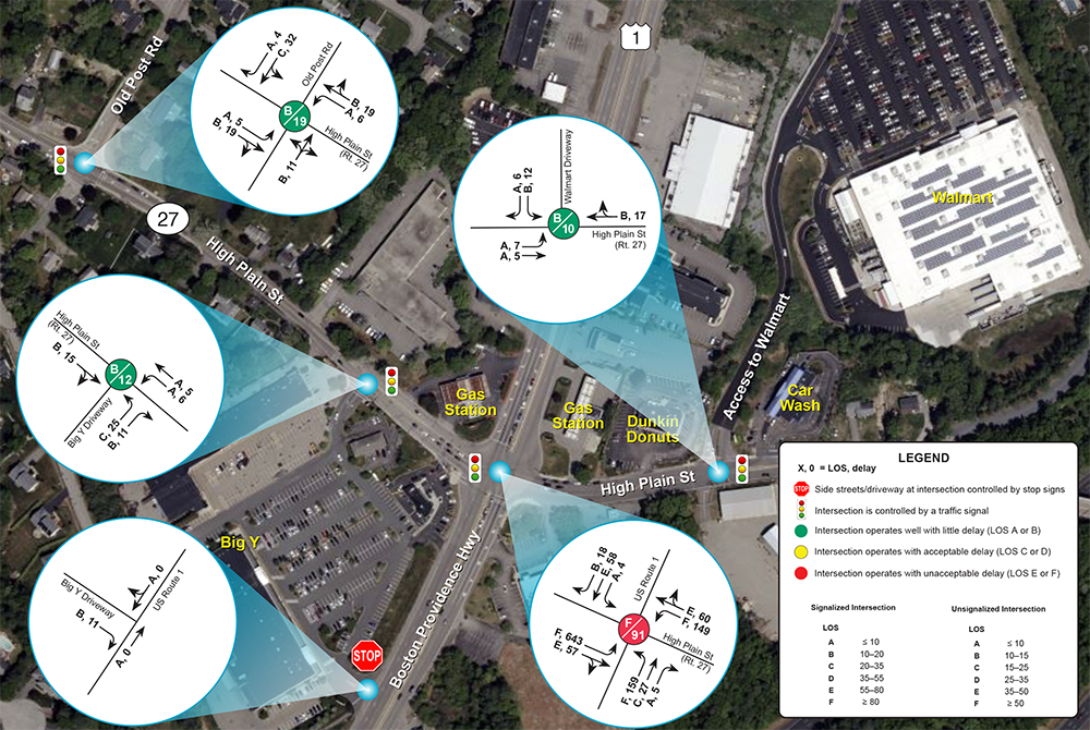
Figure 14
Weekday PM Peak-Hour LOS and Delays
LOS = Level of Service.
Source: Boston Region MPO staff.
As shown in Figures 13 and 14, most intersections in the study area operate acceptably at both peak periods, with little delay during both the AM and PM peak periods. The intersections of High Plain Street with Old Post Road, the Walmart driveway, and the Big Y driveway all operate at either LOS A or B during both weekday peak periods.
The primary operational deficiency in the study area occurs at the signalized intersection of Route 1 and High Plain Street. The intersection operates at LOS E during the weekday AM peak hour and LOS F during the weekday PM peak hour, and delays increase from approximately 64 seconds in the AM peak periods to approximately 91 seconds in the PM peak periods. The weekday PM peak period experiences the highest delays. Intersections experiencing the highest delays and lower LOS highlight areas where congestion and operational issues are most pronounced during the peak hours. Table 2 summarizes the delays and LOS for the existing conditions.
Table 2
Summary of AM and PM Peak Delay, and LOS for the Study Intersections
Intersection (all approaches) |
AM Peak: Delay (seconds) |
AM Peak: LOS |
PM Peak: Delay (seconds) |
PM Peak: LOS |
US Route 1 at High Plain Street |
64 * |
E |
91 * |
F |
Big Y Complex at High Plain Street |
8 |
A |
12 |
B |
Old Post Road at High Plain Street |
20 |
B |
19 |
B |
Walmart entrance at High Plain Street |
7 |
A |
10 |
B |
* Note: LOS causes heavy delays.
LOS = Level of Service.
Source: Boston Region MPO staff.
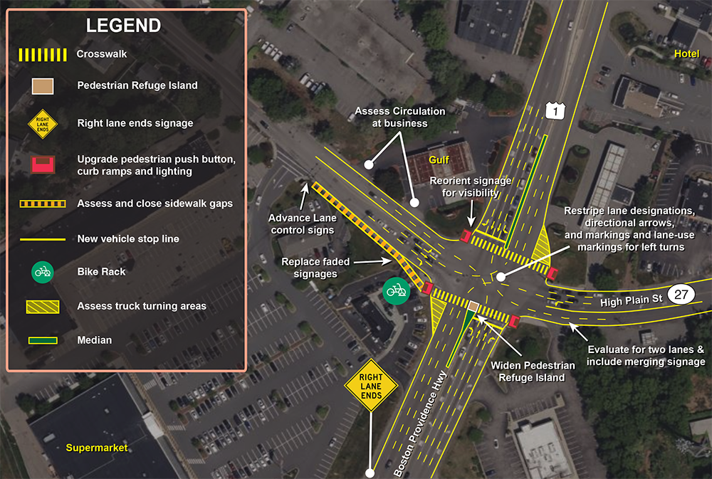
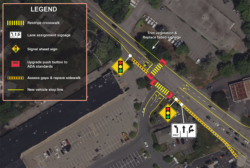
Based on the above analyses, MPO staff developed a series of short- and long-term improvements to address the identified safety and operational concerns in each intersection within the study area (Figures 15-18).
The proposed short-term improvements generally can be implemented within a few years at a low cost, through maintenance, signal timing and phasing adjustments, signage installation, and pavement marking improvements. The proposed long-term improvements would require additional planning, design, and significant funding to implement.
Figure 15
Improvements: US Route 1 at High Plain Street
Source: Boston Region MPO staff.
Figure 16
Improvements: Big Y Complex at High Plain Street
Source: Boston Region MPO staff.
Figure 17
Improvements: Old Post Road at High Plain Street
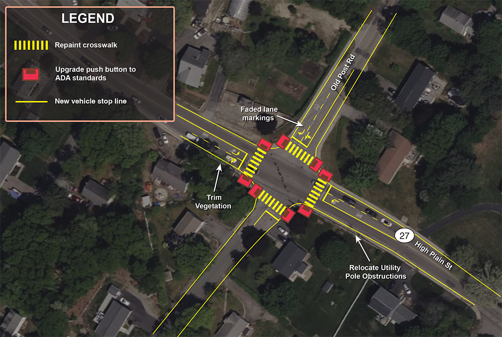
Source: Boston Region MPO staff.
Figure 18
Improvements: Walmart Entrance at High Plain Street
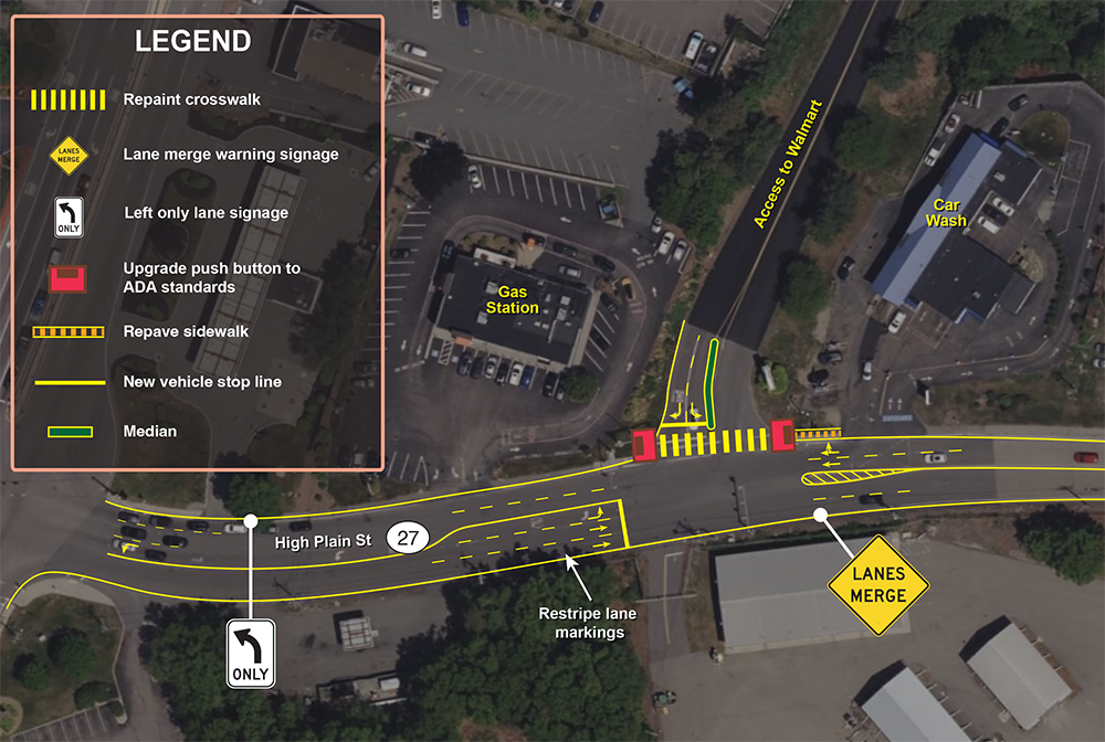
Source: Boston Region MPO staff.
Traffic operations were evaluated for the existing conditions, the 2040 No-Build scenario, and for a scenario that assumes traffic operations improvements at the intersection, the 2040 Build scenario, using Synchro analysis. The 2040 No-Build scenario represents future conditions without geometric modifications or changes to intersection operations. The Build scenario was developed to represent improved traffic operations at the intersections that address future traffic demand. Detailed Synchro results can be found in Appendices M through R.
The Build alternative retains the existing intersection geometry and traffic control, with no additional travel lanes proposed. The focus is on optimizing traffic signal timing and phasing within the existing intersection geometry. The Build model assumes changes to the signal cycle length and allocation of green time among phases, as well as changes to pedestrian signal timing. These operational improvements are intended to improve overall traffic operations under future traffic conditions.
The results of the Synchro analysis indicate that the Build alternative improves operations compared to the 2040 No-Build scenario for certain intersections including the Route 1 at High Plain Street intersection during both the AM and PM peak hours. Under the 2040 No-Build scenario, this intersection operates at LOS D during the AM peak hour and LOS F during the PM peak hour, with average delays of approximately 53 seconds and 110 seconds, respectively. Under the Build scenario, AM peak operations remain at LOS D with average delay reduced to approximately 46 seconds. During the PM peak hour, the Build alternative reduces average delay to approximately 78 seconds and the intersection operates at LOS E due to high traffic demand.
The Build alternative also improves operations at the Big Y Complex intersection. Under the 2040 No-Build scenario, the intersection is projected to operate at LOS D during the AM peak hour. Under the Build scenario, operations improve to LOS A. During the PM peak hour, the 2040 Build scenario also improves operations from LOS B under existing conditions to LOS A under future Build scenario.
The intersections of High Plain Street at Old Post Road and at the Walmart driveway continue to operate at acceptable levels of service under the 2040 No-Build scenario, with only minor changes in delay and overall operations.
This study included a series of safety and operations analyses, identified issues and concerns in the study area, and proposed short- and long-term improvements at the intersections. The proposed short- and long-term improvements would enhance safety and operations at the intersections.
At this preliminary planning stage, staff recommend that the proposed alternatives be included for further consideration and investigated at the functional design stage. The proposed improvements can be implemented as resources become available, including through highway maintenance or local Chapter 90 funding or through Shared Streets and Spaces grants.
MassDOT has jurisdiction over the Route 1 and High Plain Street intersection, while the secondary intersections in the study area are owned by the Town of Walpole. They are both responsible for improving safety, mobility, connectivity, and operations at these intersections. This study gives the Town of Walpole an opportunity to address the needs of the intersection and plan for design and engineering. The next steps will include coordination with MassDOT on the preferred alternative that is suitable to achieve the goals for the intersections, meet the needs of the stakeholders, and advance the project through the planning process. These next steps will depend upon coordination between MassDOT, the Town of Walpole, and the MPO to begin the project notification and review process and complete the project initiation form. After completing the initial steps, the Town and MassDOT staff can start preliminary design and engineering to place the project in the Boston Region MPO’s Transportation Improvement Program.
Acknowledgements: Special thanks to Seth Asante and Dorcas Okaidjah, who contributed to this study.
CIVIL RIGHTS NOTICE TO THE PUBLIC
Welcome. Bem Vinda. Bienvenido. Akeyi. 欢迎. 歡迎 .
You are invited to participate in our transportation planning process, free from discrimination. The Boston Region Metropolitan Planning Organization (MPO) is committed to nondiscrimination in all activities and complies with Title VI of the Civil Rights Act of 1964, which prohibits discrimination on the basis of race, color, or national origin (including limited English proficiency). Related federal and state nondiscrimination laws prohibit discrimination on the basis of age, sex, disability, and additional protected characteristics.
For additional information or to file a civil rights complaint, visit www.bostonmpo.org/mpo_non_discrimination .
To request accommodations at meetings (such as assistive listening devices, materials in accessible formats and languages other than English, and interpreters in American Sign Language and other languages) or if you need this information in another language, please contact:
Boston Region MPO Title VI Specialist
10 Park Plaza, Suite 2150
Boston, MA 02116
Phone: 857.702.3700
Email: civilrights@ctps.org
For people with hearing or speaking difficulties, connect through the state MassRelay service, www.mass.gov/massrelay. Please allow at least five business days for your request to be fulfilled.