TECHNICAL MEMORANDUM
DATE: July 19, 2024
TO: Towns of Hamilton and Ipswich
FROM: Shravanthi Gopalan Narayanan and Srilekha Murthy,
Boston Region MPO Staff
RE: FFY 2024 Community Transportation Technical Assistance Program: Traffic-calming in Hamilton and Ipswich
The Boston Region Metropolitan Planning Organization (MPO) provides municipalities with technical assistance on local transportation issues through its Community Transportation Technical Assistance (CTTA) Program. This memorandum details the results of a transportation study on Goodhue Street in the Towns of Hamilton and Ipswich, Massachusetts, funded through this program.
Town staff from Hamilton and Ipswich reached out to MPO staff in November 2023 with a request to study Goodhue Street and adjacent intersections (at Highland Street and Waldingfield Road) owing to concerns raised by residents about the area being used as a cut-through by vehicles traveling at high speeds. Town staff requested that pedestrian access and speeding also be reviewed as part of this study.
In response to this request, MPO staff conducted a site visit and collected data on traffic volumes and vehicle travel speeds to understand whether and to what extent Goodhue Street is being used as a cut-through. Based on our analysis, we provide short-term and longer-term recommendations to enhance safety for all road users, lower speeds, and improve sight distance. We also analyze and discuss whether the possibility of making Goodhue Street a one-way roadway reduces the cut-through traffic.
As Goodhue Street and Waldingfield Road are scenic routes, any improvements on these roadways must be reviewed by the Planning Board before implementation.1
Our recommendations include (1) redesigning the intersection of Goodhue Street at Highland Street; (2) traffic-calming to improve safety at the intersections of Waldingfield Road at Goodhue Street and Highland Street at Waldingfield Road; and (3) installation of signage within the study area.
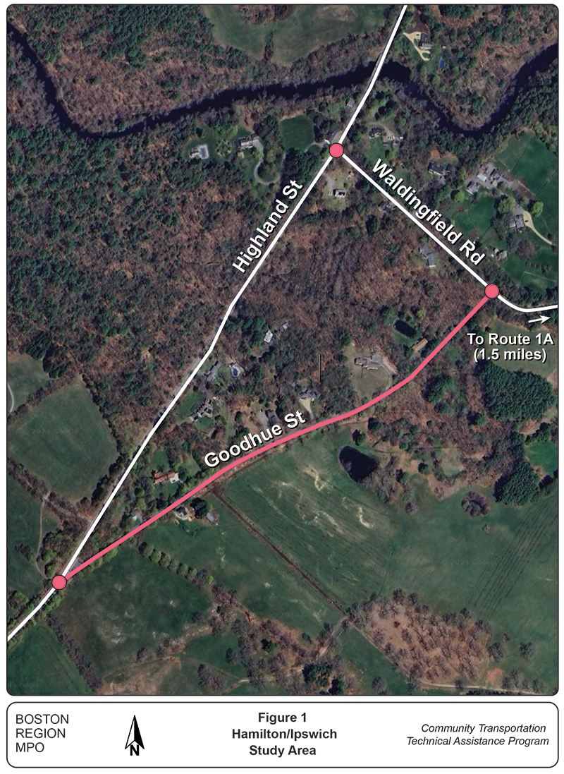
Figure 1 shows the three intersections of interest in the study area. In this study, MPO staff analyzed existing conditions and proposed recommendations for safer pedestrian crossings and traffic-calming measures at each intersection.
Figure 1
Study Area in Hamilton and Ipswich, Massachusetts

Source: Boston Region MPO Staff..
The study area lies along the boundary of the towns of Hamilton and Ipswich, both of which are members of the North Shore Task Force subregion in the Boston metropolitan area. The Hamilton-Ipswich town line bisects Goodhue Street. Both Hamilton and Ipswich are home to many natural resources, including Appleton Farms in Hamilton and Crane Estate in Ipswich.
Highland Street is a town-accepted, rural major collector road that carries local traffic through Hamilton, from the border of Hamilton and Wenham to the border of Hamilton and Ipswich.2 The section of Highland Street in the study area is a two-way road with one lane in each direction. It runs north-south and there is a posted speed limit sign of 40 miles per hour (mph) southbound. The paved roadway is about 24 feet wide, with two 11-foot travel lanes and a two-foot shoulder on either side of the road. There are no sidewalks or bike lanes on Highland Street. The land uses surrounding Highland Street are primarily residential and equestrian farms and stables.
Goodhue Street is a town-accepted, local road that carries primarily residential traffic from Highland Street to Waldingfield Road and crosses the border with Ipswich. It runs north-south and operates as a two-way road with one lane in each direction. The paved roadway is about 18 feet wide and has no lane markings. Goodhue Street lacks sidewalks, bike lanes, and speed limit signs. It has stone walls on either side of the street. The surrounding land uses are residential and conservation with equestrian farms and stables; Appleton Farms borders Goodhue Street to the east.
Waldingfield Road is a town-accepted, local road that runs east-west. It operates as a two-way road with one lane in each direction that carries traffic from Highland Street into Ipswich, and shares an intersection with Goodhue Street. The paved roadway is about 18 feet wide and has no lane markings. There are no sidewalks or bike lanes on Waldingfield Road, and the street has posted speed limit signs of 25 mph. The surrounding land uses are primarily residential with equestrian farms and stables, and one lot (outside the study area) recently slated for development as a corporate business retreat.
Goodhue Street connects with Highland Street to the south and Waldingfield Road to the north. Goodhue Street could potentially be used as a cut-through by northbound drivers on Highland Street who are traveling to Waldingfield Road, which leads to Route 1A. This route would allow them to avoid the intersection at Highland Street and Waldingfield Road.
The study area contains three intersections:
Goodhue Street at Highland Street
The intersection of Goodhue Street and Highland Street (Figure 2) is an unsignalized, Y intersection with a stop sign and a stop bar for vehicles approaching the intersection southbound from Goodhue Street. A median with vegetation demarcates Goodhue Street from Highland Street. There is a National Grid-owned electric pole at this median.
Figure 2
Goodhue Street at Highland Street Intersection
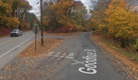
Source: Google Street View (October 2019).
Goodhue Street at Waldingfield Road
The intersection of Goodhue Street at Waldingfield Road (Figure 3) is an unsignalized, T intersection with a stop sign and a stop bar for vehicles approaching the intersection northbound from Goodhue Street.
Figure 3
Goodhue Street at Waldingfield Road Intersection
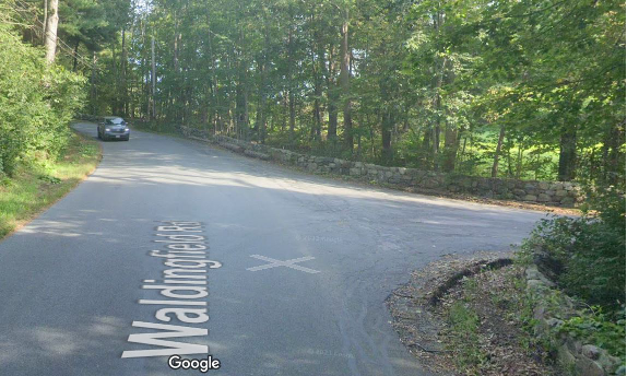
Source: Google Street View (September 2023).
Highland Street at Waldingfield Road
The intersection of Highland Street at Waldingfield Road (Figure 4) is an unsignalized, T intersection with a stop sign and a stop bar for vehicles approaching the intersection westbound from Waldingfield Road.
Figure 4
Highland Street at Waldingfield Road Intersection
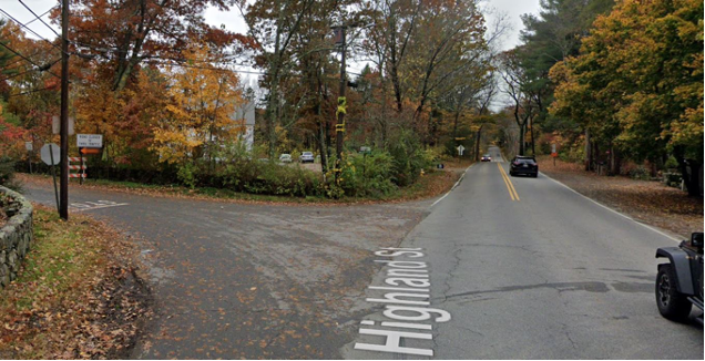
Source: Google Street View (October 2019).
MPO staff met with the following staff from the Towns of Hamilton and Ipswich for an in-person site visit on Tuesday, January 23, 2024:
We conducted a walk-through of Goodhue Street and adjacent intersections and took photographs and videos of existing conditions at each intersection. We also discussed issues and concerns in the study area with representatives from the Towns of Hamilton and Ipswich.
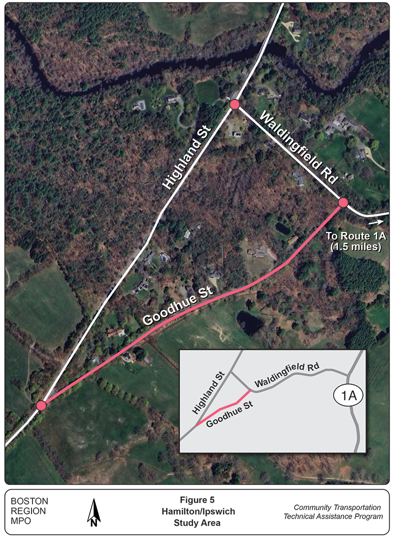
Town staff discussed several safety and speeding issues with MPO staff. The primary concerns were that Goodhue Street is used as a cut-through for vehicles looking to bypass Route 1A, and that people driving these vehicles frequently speed through residential roads and intersections. Figure 5 shows the proximity of the study area to Route 1A.
Figure 5
Proximity of the Study Area to Route 1A
Source: Boston Region MPO Staff..
MPO staff observed that a portion of a stone retaining wall near Goodhue Street at Waldingfield Road intersection had been damaged due to a truck striking it during a storm. However, there was no other crash history from the MassDOT IMPACT Portal in the study area.3 Additional concerns identified by Town staff were poor sight distances at the intersection of Goodhue Street at Waldingfield Road, and at the intersection of Highland Street at Waldingfield Road.
A new corporate retreat facility has been proposed for development on Waldingfield Road, and residents have expressed concern about the potential additional traffic that might be added to these roadways. The traffic impact of this new facility must be taken into consideration when considering potential improvements to the site.
MPO staff collected several types of data to understand and analyze the existing conditions during the week of January 29, 2024. These data comprise turning movement counts (TMCs) at all three intersections, average weekday traffic volumes, and speed data for the roadways within the study area.
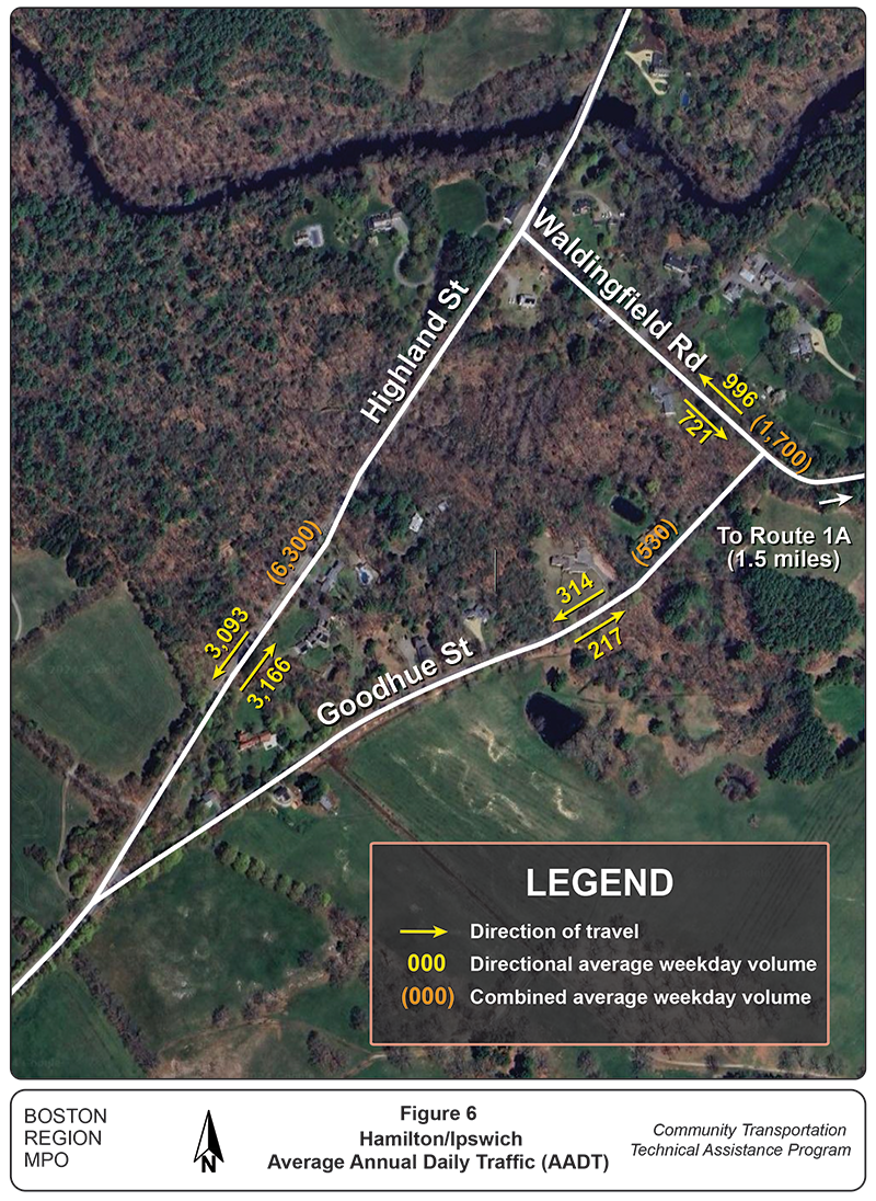
The combined average weekday traffic volumes (Figure 6) in roadway sections near the intersections are described as follows:
Figure 6
Average Weekday Traffic Volumes
Source: Boston Region MPO Staff.
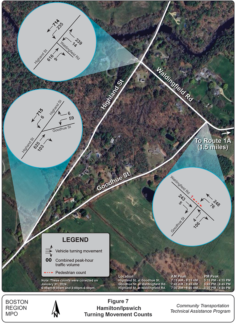
MPO staff collected TMCs at all three intersections in the study area for the morning peak period (between 6:00 AM and 9:00 AM) and the evening peak period (between 3:00 PM and 6:00 PM). In addition to vehicles, TMCs also include pedestrians and bicyclists traveling through the intersection. We show the TMC data for the three intersections in Figure 7.
Figure 7
Turning Movement Counts for Intersections in the Study Area
Source: Boston Region MPO Staff.
The combined peak-hour traffic volume data collected indicates that Goodhue Street is used as a cut-through by drivers traveling to Waldingfield Road from Highland Street, who are avoiding the intersection of Highland Street and Waldingfield Road. Of 200 vehicles that traveled on Goodhue Street, only four vehicles continued westbound, while 106 vehicles traveled eastbound on Waldingfield Road towards Route 1A. This suggests that Goodhue Street is indeed being used as a cut-through by a significant number of people.
Only one pedestrian was observed using the intersection of Goodhue Street and Waldingfield Road when the counts were conducted. However, during the site visit, we noticed a few bicyclists traveling westbound on Waldingfield Road and pedestrians walking from Waldingfield Road onto Goodhue Street.
Regulatory signage indicates the traffic regulations of a specific place to road users. Warning signage indicates unexpected roadway conditions on or adjacent to a road in advance to caution road users. An additional emphasis can be provided by placing object markers (Manual on Uniform Traffic Control Devices (MUTCD) Chapter 2C. Section 2C.70-73), delineators (MUTCD Chapter 3G), and/or pavement markings (MUTCD Chapter 3B) to improve safety.4
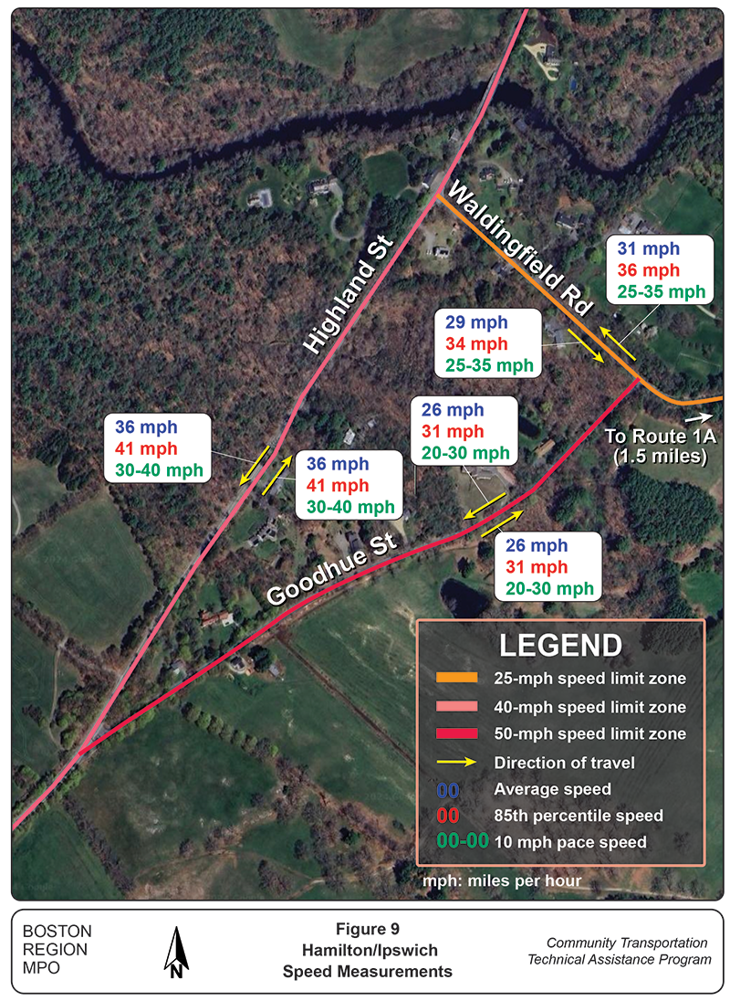
Goodhue Street does not have a posted speed limit. According to the Federal Highway Administration (FHWA), roads without a posted speed limit are automatically assigned a statutory speed limit of 55 miles per hour.5 Our data indicated that the average speed on Goodhue Street northbound and southbound traffic is 26 mph, much lower than the statutory speed limit. We typically expect that the speed limit should not exceed 25 mph for a local, residential street like Goodhue Street.
Highland Street has a posted speed limit of 40 mph for southbound traffic, while there are no posted speed signs northbound within the extent of the study area. The average speed on Highland Street northbound and southbound was found to be 36 mph, which is within the posted speed limit.
There are posted speed limit signs of 25 mph at Waldingfield Road for eastbound and westbound traffic, however, the posted speed sign for westbound traffic is right at the intersection of Goodhue Street at Waldingfield Road. We found the average speed on Waldingfield Road westbound to be 31 mph and eastbound to be 29 mph, which are both higher than the posted speed limit.
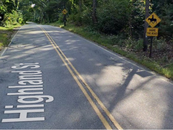
Other relevant signage in the study area includes the following:
Figure 8
Signage on Highland Street Southbound
Source: Google Street View (September 2023).
Table 1 summarizes the average speed on each roadway, the percentage of vehicles traveling within the posted speed limit, and the percentage of vehicles going over the speed limit.
Table 1
Summary of Speed Data
| Roadway |
Posted Speed Limit |
Average Speed |
Percent of Vehicles Traveling within the Posted Speed Limit |
Percent of Vehicles Speeding |
|---|---|---|---|---|
Goodhue Street |
No posted speed limit |
NB: 26 mph SB: 26 mph |
NB: 34% SB: 42% |
NB: 66% SB: 58% |
Highland Street |
40 mph |
NB: 36 mph SB: 36 mph |
NB: 79% SB: 82% |
NB: 21% SB: 18% |
Waldingfield Road |
25 mph |
EB: 29 mph WB: 31 mph |
NB: 21% SB: 11% |
NB: 79% SB: 89% |
EB = eastbound. Mph = miles per hour. NB = northbound. SB = southbound. WB = westbound.
Source: Boston Region MPO staff.
Figure 9 shows the average speed, 85th percentile speed, 10 mph pace speed, and speed limit zones for the roadways in the study area.6
Figure 9
Speed Data
Source: Boston Region MPO Staff.
When analyzing existing pavement markings, we observed the presence of both stop bars and stop signs at all three intersections. Town staff mentioned that the pavement markings on Highland Street are refreshed every year. There are no other markings on Goodhue Street and Waldingfield Road; both lane markings and crosswalks are entirely absent.
MPO staff evaluated the existing conditions to propose both short-term and long-term interventions to improve safety in the study area with input from Town staff. These recommendations are described for each intersection.
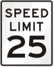
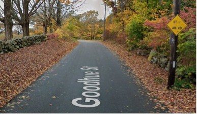
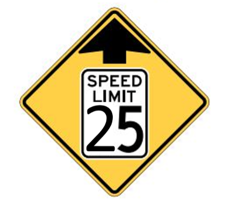
We recommend the following short-term interventions at the intersection of Goodhue Street and Highland Street:
Figure 10a
Recommended Speed Limit Sign (R2-1)
Source: MUTCD (edited by MPO staff).
Figure 10b
Recommended “Stop Ahead” Sign (W3-1)

Source: Google Street View (October 2019) (left); MUTCD (right).
Figure 10c
Recommended “Reduced Speed Limit Ahead” Sign (W3-5)
Source: MUTCD (edited by MPO staff).
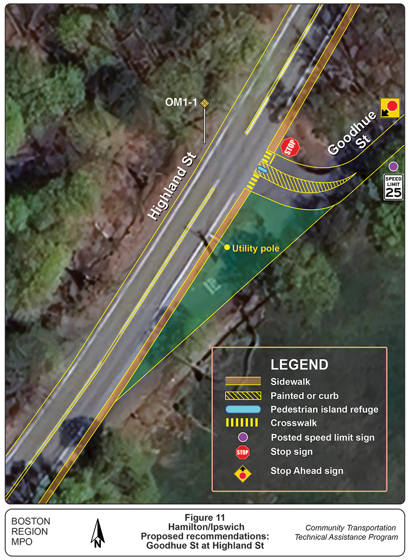
In the long-term, we recommend redesigning the intersection of Goodhue Street at Highland Street. The proposed geometry is shown in Figure 11. This redesign would close the existing right turn onto Goodhue Street from Highland Street, and instead create a T intersection further north. This geometry would require vehicles to slow down before turning onto Goodhue Street. It is recommended that a sidewalk (depending on the available right-of-way) is installed at least on the eastern side of Highland Street, and a crosswalk and pedestrian refugee island at the intersection of Goodhue Street at Highland Street. In case a sidewalk, crosswalk or pedestrian refuge island cannot be installed, a center median at the intersection is recommended to slow down the turning vehicles.
Figure 11
Proposed Geometry for Redesign of Goodhue Street at Highland Street
Source: Boston Region MPO Staff.
Town staff requested that we assess the installation of a sidewalk along Goodhue Street for pedestrians. Even though the TMCs indicate low pedestrian traffic, we observed a few pedestrians walking along Goodhue Street during our site visit. We recommend conducting exclusive pedestrian and bicyclist counts before proposing a sidewalk on Goodhue Street.
The eastern edge of Goodhue Street seems to be the most suitable location for a sidewalk, if Town staff decide to install one, because there are minimal disruptions (such as electric poles, multiple property lines, and multiple driveways). However, there is a fire hydrant located on that side of the street that would need to be relocated.
The minimum width of a sidewalk is three feet, according to the Americans with Disabilities Act (ADA).7 However, the preferred minimum sidewalk width is five feet8 .
We propose the following short-term interventions at the intersection of Goodhue Street and Waldingfield Road:
Figure 12a
Existing Pavement Condition on Goodhue Street
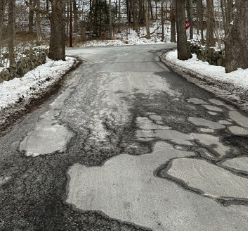
Source: Photograph by MPO staff.
Figure 12b
Recommended “Share the Road” Sign (W16-1P)

Source: Bicycle “Three Feet Clearance” Sign Guide.
Figure 12c
Posted Speed Limit Sign on Waldingfield Road
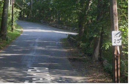
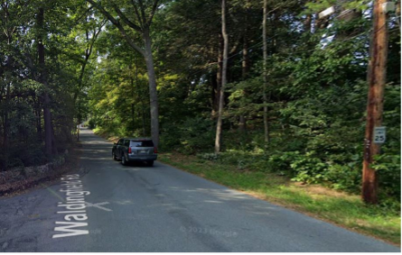
Note: Eastbound view (top). Westbound view (bottom).
Source: Google Street View (September 2023).
Table 12d
Sight Distance at the Intersection of Goodhue Street and Waldingfield Road
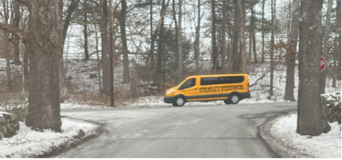
Source: Photograph by MPO staff.
We recommend the following long-term interventions for this intersection:
Figure 13
Chevron Alignment Sign (W1-8)
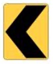
Source: MUTCD.
Figure 14 summarizes the proposed traffic-calming strategies at the intersection of Goodhue Street at Waldingfield Road. Traffic-calming strategies are included to tighten the intersection, thereby reducing excess pavement and improving sight distance for all road users. This redesign recommends that a sidewalk (depending on the available right-of-way) is installed at least on the southern side of Waldingfield Road. This redesign includes a crosswalk with a pedestrian refuge island, which would provide a safe crossing environment for pedestrians and a visual cue to remind drivers to slow down when approaching the intersection and/or making turns. If a sidewalk, crosswalk or pedestrian refuge island cannot be installed, a center median at the intersection is recommended to slow down the turning vehicles.
Figure 14
Proposed Traffic-calming Strategies at the Intersection of Goodhue Street at Waldingfield Road
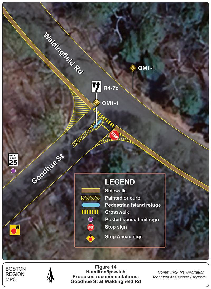
Source: Boston Region MPO Staff.
We recommend the following short-term interventions at the intersection of Waldingfield Road and Highland Street:
Figure 15
Recommended Shoulder
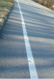
Source: Rumble Strip Implementation Guide.
We believe that the issues at Waldingfield Road and Highland Street can be addressed with short-term improvements; therefore, we are not proposing any long-term recommendations.
In addition to proposing short-term and long-term interventions, Town staff had suggested we also evaluate the possibility of converting Goodhue Street to a one-way street southbound.
Instead of a one-way conversion of Goodhue Street, we propose redesigning the geometry of the intersection of Goodhue Street at Highland Street (see Figure 11), The design would close one of the entrances to Goodhue Street and create a T intersection at the other, forcing vehicles to slow down before turning onto Goodhue Street regardless of the direction from which they approach the intersection.
The primary reason for this proposed redesign would be to reduce the use of Goodhue Street as a cut through. Our traffic count data suggests that Goodhue Street is being used as a cut-through by a significant number of people driving to Route 1A and avoiding the intersection of Highland Street and Waldingfield Road.
A secondary reason for the proposed redesign is to narrow the intersection approaches and to reduce speeding along Goodhue Street. Currently, drivers traveling north on Highland Street towards Goodhue Street may not slow down adequately before continuing on Goodhue Street. To further improve safety, stop signs with flashing LEDs (Figure 16) can be installed at all three intersections for better visibility at nighttime.
Figure 16
Stop Sign with LED Border

Source: MUTCD Section 2A.11, page 48.
The Towns of Hamilton and Ipswich requested that the MPO staff examine Goodhue Street and adjacent intersections (at Highland Street and Waldingfield Road) and evaluate vehicle speeding and sight distances issues. They also asked us to study whether Goodhue Street is being used as a cut-through by drivers traveling to Route 1A and other safety concerns. We analyzed the traffic data and came up with inferences based on the results.
The recommendations discussed in this memo are both short-term and long-term solutions. Short-term recommendations include safety improvements that are easy to install and do not require significant time to implement, such as pavement markings and signage that inform and warn drivers of roadway conditions. The long-term recommendations include options for redesigning the intersections of Goodhue Street to address identified challenges. And finally, we discussed whether making Goodhue Street a one-way roadway helps to reduce challenges of the study area. The recommendations discussed in this memo are focused on enhancing safety for people walking, biking, and driving by improving roadway conditions.
Appendices
Appendix A
Automatic Traffic Recorder (ATR) and Turning Movement Count (TMC) Locations
Appendix B
ATR Data
Appendix C
TMCs Goodhue Street at Highland Street
Appendix D
TMCs Goodhue Street at Waldingfield Road
Appendix E
TMCs Highland Street at Waldingfield Road
Appendix F
Speed Data
1 For a history of Hamilton’s streets, see https://hwlibrary.org/wp-content/uploads/2018/11/Streets-history_web.pdf.
2 The process to have a roadway accepted is a statutory process that follows Massachusetts General Law and requires a town meeting vote.
3 MassDOT IMPACT Portal is a dashboard used for researching crash-related data in Massachusetts. See https://apps.impact.dot.state.ma.us/cdp/home.
4 The Manual on Uniform Traffic Control Devices (MUTCD) is a document issued by the FHWA that specifies the standards for traffic signs, road surface markings, and signals to be designed, installed, and used. See https://mutcd.fhwa.dot.gov/.
5 See the FHWA’s Speed Limit Basics, https://highways.dot.gov/media/13911.
6 According to FHWA, “The 10 mph pace is the 10 mph range encompassing the greatest percentage of all the measured speeds in a spot speed study.” See the FHWA’s Methods and Practices for Setting Speed Limits: An Informational Report, https://safety.fhwa.dot.gov/speedmgt/ref_mats/fhwasa12004/fhwasa12004.pdf.
7 See the Americans with Disabilities Act, Section 403.5.1, https://www.access-board.gov/ada/chapter/ch04/.
8 See the Massachusetts Department of Transportation’s directive, Controlling Criteria and Design Justification Process for MassDOT Highway Division Projects, at https://www.mass.gov/doc/controlling-criteria-and-design-justification-process-for-massdot-highway-division-projects-e/download.